
Order Total (1 Item Items):
Shipping Destination:

1816 Gotha (25 results)
Skip to main search results
Search filters
Product Type
- All Product Types
- Books (21)
- Magazines & Periodicals (No further results match this refinement)
- Comics (No further results match this refinement)
- Sheet Music (No further results match this refinement)
- Art, Prints & Posters (3)
- Photographs (No further results match this refinement)
- Maps (No further results match this refinement)
- Manuscripts & Paper Collectibles (1)
Condition Learn more
- New (No further results match this refinement)
- As New, Fine or Near Fine (No further results match this refinement)
- Very Good or Good (No further results match this refinement)
- Fair or Poor (No further results match this refinement)
- As Described (25)
Binding
- All Bindings
- Hardcover (3)
- Softcover (No further results match this refinement)
Collectible Attributes
- First Edition (No further results match this refinement)
- Signed (1)
- Dust Jacket (No further results match this refinement)
- Seller-Supplied Images (24)
- Not Print on Demand (25)
Language (2)
Price
- Any Price
- Under � 20 (No further results match this refinement)
- � 20 to � 35 (No further results match this refinement)
- Over � 35
Free Shipping
- Free Shipping to U.S.A. (No further results match this refinement)
Seller Location
Seller Rating
-

Dr. K. von Spruner's Historisch-Geographischer Schul-Atlas.
Published by Artist: Perthes Justus ( - 1816 ) Gotha; issued in: Gotha; dated: 1860, 1749
Seller: Antique Sommer& Sapunaru KG, M�nchen, Germany
Seller rating 4 out of 5 stars

Technic: Steel engraving, colorit: original colored, condition: Binding carton, size (in cm): 24,5 x 31 cm, Atlas with 20 (of 22) maps. 2 x world, Europe in different ages, the Ottoman Empire, England, Asia etc.On 8 pages description.
-

Condition: Buono (Good). acquaforte cm. 49 x 40,5 Buono (Good) Buon esemplare, solo una piccola mancanza sul bordo della tavola Nove. Book.
-
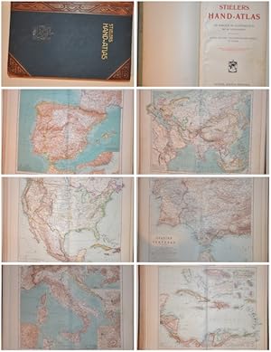
Stielers Hand-Atlas
Published by Artist: Perthes Justus ( - 1816 ) Gotha; issued in: Gotha; : 1905, 1749
Seller: Antique Sommer& Sapunaru KG, M�nchen, Germany
Seller rating 3 out of 5 stars

Technic: Copper print, colorit: colored, condition: Binding in hardcover with leather embossed in gold, size (in cm): 40 x 27 cm, Stieler's Hand Atlas. 100 maps in copper engraving. With 162 subsidiary maps. Published by Justus Perthes' Geographical Institute in Gotha. Ninth edition, completely revised and redesigned.
-

Portr�t. Brustbild in Uniform als "Don Fernando Prinz von S. Coburg". Original - Stahlstich von Carl Mayer, 11,5 x 8,5 cm, ca. 1850.
Seller: Antiquariat Michael Eschmann, Gro�-Gerau, Germany
Seller rating 5 out of 5 stars

Art / Print / Poster
0. Sprache: Deutschu.
-

Portr�t. Halbfigur. Original - Stahlstich (anonym), 24,5 x 15,5 cm, ca. 1850.
Seller: Antiquariat Michael Eschmann, Gro�-Gerau, Germany
Seller rating 5 out of 5 stars
Art / Print / Poster
0. Sprache: Deutschu.
-

Portr�t. Brustbild. Kupferstich von Friedrich M�ller nach Amalie L�ffler, 23 x 18 cm, um 1800.
Seller: Antiquariat Michael Eschmann, Gro�-Gerau, Germany
Seller rating 5 out of 5 stars
Art / Print / Poster
0. *** Diepenbroick 15460. *** Am Rand leicht fleckig. Sprache: Deutschu.
-

Afrika nach den neuesten Entdeckungen
Published by Artist: Perthes Justus ( - 1816 ) Gotha; issued in: Gotha; ca: 1850, 1749
Seller: Antique Sommer& Sapunaru KG, M�nchen, Germany
Seller rating 4 out of 5 stars
Technic: Copper print, colorit: colored, condition: Very good, size (in cm): 17 x 21, Map shows complete Africa with all its countries.
-

Australien und Polynesien.
Published by Artist: Perthes Justus ( - 1816 ) Gotha; issued in: Gotha; ca: 1860, 1749
Seller: Antique Sommer& Sapunaru KG, M�nchen, Germany
Seller rating 4 out of 5 stars
Technic: Steel engraving, colorit: original colored, condition: Perfect condition, size (in cm): 21 x 25,5 cm, Map shows the Pacific Ocean with parts of China, Southeast Asia, Japan, Australia, New Zealand, Polynesia and North America. Furthermore, a partial map with the southeast of Australia including Tasmania and an elevation map of some Australian and Polynesian mountains. From Stielers school atlas.
-

Die preussischen Provinzen Preussen und Posen bearbeitet von C. Vogel.
Published by Artist: Perthes Justus ( - 1816 ) Gotha; issued in: Gotha; ca: 1816, 1749
Seller: Antique Sommer& Sapunaru KG, M�nchen, Germany
Seller rating 4 out of 5 stars
Technic: Steel engraving, colorit: original colored, condition: Perfect condition, size (in cm): 32 x 40 cm, Map depicts Poland and Prussi with two inset maps: A map of Berlin and an oversight map of Prussia in 1816. Issued in the famous Stielers Atlas. From Stielers hand atlas.
-

S�d America zur �bersicht der Entdeckung, Eroberung und Colonisation
Published by Artist: Perthes Justus ( - 1816 ) Gotha; issued in: Gotha; ca: 1850, 1749
Seller: Antique Sommer& Sapunaru KG, M�nchen, Germany
Seller rating 4 out of 5 stars
Technic: Lithography, colorit: original colored, condition: Perfect condition, size (in cm): 30,5 x 36,5 cm, A Map of South America Containing Tierra-Firma, Guayana, New Granada, Amazonia, Brasil, Peru, Paraguay, Chaco, Tucuman, Chile and Patagonia.
-

Das Capland nebst den n�rdlich angrenzenden Gebieten
Published by Artist: Perthes Justus ( - 1816 ) Gotha; issued in: Gotha; : 1867, 1749
Seller: Antique Sommer& Sapunaru KG, M�nchen, Germany
Seller rating 4 out of 5 stars
Technic: Steel engraving, colorit: original colored, condition: Very good, size (in cm): 34 x 41 cm, Map shows South Africa with its surrounding areas and a plan of Cape Town with Table Bay. From Stieler's Hand Atlas.
-

S�d- Africa mit Madagascar
Published by Artist: Perthes Justus ( - 1816 ) Gotha; issued in: Gotha; dated: 1854, 1749
Seller: Antique Sommer& Sapunaru KG, M�nchen, Germany
Seller rating 4 out of 5 stars
Technic: Steel engraving, colorit: colored, condition: Very good, size (in cm): 32 x 39, Map shows South Africa with the island Madagascar.
-

S�d-Africa mit Madagascar.
Published by Artist: Perthes Justus ( - 1816 ) Gotha; issued in: Gotha; : 1866, 1749
Seller: Antique Sommer& Sapunaru KG, M�nchen, Germany
Seller rating 3 out of 5 stars
Technic: Steel engraving, colorit: original colored, condition: Perfect condition, size (in cm): 33 x 39 cm, Map shows Southern Africa up to the equator with Madagascar, the Amirantes, Reunion Island in the Indian Ocean and three profile maps of the highlands. From Stieler's Hand Atlas.
-

Afrika nach den arabischen Geographen und bis zur Ankunft der Portugiesen, VIIItes bis XIVtes Jahrhundert.
Published by Artist: Perthes Justus ( - 1816 ) Gotha; issued in: Berlin; ca: 1850, 1749
Seller: Antique Sommer& Sapunaru KG, M�nchen, Germany
Seller rating 4 out of 5 stars
Technic: Lithography, colorit: original colored, condition: Perfect condition, size (in cm): 29 x 35,5 cm, Map shows all of Africa with Madagascar, Arabia, Persia, partly Europe, the coast of Brazil and the coast of the province of Nova Scotia in Canada.
-

Der s�dliche Theil von S�d- America
Published by Artist: Perthes Justus ( - 1816 ) Gotha; issued in: Gotha; dated: 1875, 1749
Seller: Antique Sommer& Sapunaru KG, M�nchen, Germany
Seller rating 4 out of 5 stars
Technic: Steel engraving, colorit: colored, condition: Perfect condition, size (in cm): 32 x 40,5 cm, Map shows the south part of South America with a map of Rio de Janeiro and the Bay of Rio on inset maps.
-

Asia entw. u. gez. von L. von St�lpnagel.
Published by Artist: Perthes Justus ( - 1816 ) Gotha; issued in: Gotha; dated: 1862, 1749
Seller: Antique Sommer& Sapunaru KG, M�nchen, Germany
Seller rating 4 out of 5 stars
Technic: Steel engraving, colorit: original colored, condition: Perfect condition, size (in cm): 32 x 36, Decorative map of total Asia with an index of description. From Stielers hand atlas.
-

Palaestina
Published by Artist: Perthes Justus ( - 1816 ) Gotha; issued in: Gotha; ca: 1850, 1749
Seller: Antique Sommer& Sapunaru KG, M�nchen, Germany
Seller rating 4 out of 5 stars
Technic: Steel engraving, colorit: colored, condition: Some restoration at centerfold, size (in cm): 29 x 22 cm, Map shows Holy Land and two insert maps showing a city map of Jerusalem and a map of the area of the 12 tribes.
-

S�d America in zwei Bl�ttern, gezeichnet von F. v. St�lpnagel.
Published by Artist: Perthes Justus ( - 1816 ) Gotha; issued in: Gotha; ca: 1873, 1749
Seller: Antique Sommer& Sapunaru KG, M�nchen, Germany
Seller rating 3 out of 5 stars
Technic: Steel engraving, colorit: original colored, condition: Printed on 2 sheets joined together, size (in cm): 59,5 x 40 cm, Detailed Map of South America Containing Tierra-Firma, Guayana, New Granada, Amazonia, Brasil, Peru, Paraguay, Chaco, Tucuman, Chile, Patagonia and two inset maps with Rio de Janeiro. From Stieler's Handatlas.
-

Polynesien und der Grosse Ocean
Published by Artist: Perthes Justus ( - 1816 ) Gotha; issued in: Gotha; : 1869, 1749
Seller: Antique Sommer& Sapunaru KG, M�nchen, Germany
Seller rating 3 out of 5 stars
Technic: Steel engraving, colorit: original colored, condition: Tear on lower part perfectly restored, size (in cm): 34,5 x 40,5 cm, Map shows the Pacific with Southeast Asia, China, Japan, Australia, New Zealand and partly Kamchatka. Furthermore 17 partial maps with New Caledonia, Tonga, Norfolk, Fiji, Samoa, the Caroline Islands, Marianas, etc. Engraved by Stier & Jungmann. From Stielers hand atlas.
-

Petermann: Vereinigte Staaten von Nord-Amerika
Published by Artist: Perthes Justus ( - 1816 ) Gotha; issued in: Gotha; dated: 1875, 1749
Seller: Antique Sommer& Sapunaru KG, M�nchen, Germany
Seller rating 4 out of 5 stars
Technic: Steel engraving, colorit: original colored, condition: Perfect condition, size (in cm): 33 x 40,5 cm, Map depicts the eastern coast of the US with Alabama, Florida, Georgia, Tennessee, Nord und S�d Carolina, Kentucky and Virginia. On 2 inset maps the southern part of Florida and Texas. From Stielers Atlas.
-

Westliche Halbkugel Oestliche Halbkugel/ Theil von Australien
Published by Artist: Perthes Justus ( - 1816 ) Gotha; issued in: Gotha; ca: 1850, 1749
Seller: Antique Sommer& Sapunaru KG, M�nchen, Germany
Seller rating 4 out of 5 stars
Technic: Steel engraving, colorit: colored, condition: Very good, size (in cm): 19 x 26, Map shows the world in two hemispheres and Australia with New Zeeland and 4 different hemispheres ( northern, southern, biggest water quantity, biggest land quantity) From Stielers school atlas.
-

Das Capland nebst den S�d-Afrikanischen Freistaaten und dem Gebiet der Kaffern u. Hottentotten.
Published by Artist: Perthes Justus ( - 1816 ) Gotha; issued in: Gotha; : 1855, 1749
Seller: Antique Sommer& Sapunaru KG, M�nchen, Germany
Seller rating 4 out of 5 stars
Technic: Steel engraving, colorit: original colored, condition: Perfect condition, size (in cm): 32,5 x 42,5 cm, Map shows South Africa with its surrounding areas and a profile map. Furthermore, a partial map with Cape Town, Table Bay and False Bay at the Cape of Good Hope. From Stieler's Hand Atlas.
-

Erdkarte in Mercator's
Published by Artist: Perthes Justus ( - 1816 ) Gotha; issued in: Gotha; ca: 1850, 1749
Seller: Antique Sommer& Sapunaru KG, M�nchen, Germany
Seller rating 4 out of 5 stars
Technic: Steel engraving, colorit: original colored, condition: Some restoration at lower centerfold, size (in cm): 19,5 x 23 cm, The map shows the entire world with travel and trade routes in the Atlantic, Indian Ocean, North and South Pacific. The Mercator projection, introduced by Gerardus Mercator in 1569, is a cylindrical map projection developed for navigation. It preserves angles and the shapes of small objects, which made it extremely useful for sailors.
-

Original-Dokument (1 S. 4 to, Vordruck, Mittelfalte, zwei Flecken) in Tinte eigenh�ndig ausgef�llt und mit Ort, Datum, Unterschrift als ord. Prof der Theologie signiert Jena, 22.III.1820 - STUDIENZEUGNIS f�r Christian Ackermann aus Weimar �ber besuchte Vorlesungen zur Kirchengeschichte, mit ausgezeichnetem Fleisse besucht. (CONSTANTIN ACKERMANN, auch Konstantin Ackermann (* 15. April 1799 in Ilmenau ; ? 5. Oktober 1877 in Meiningen , deutscher evangelischer Geistlicher. 1817 bis 1820 studierte er an der Universit�t Jena und ab dem 23. April 1820 unter dem Prorektor Friedrich Heinrich Christian Schwarz an der Universit�t Heidelberg Theologie ; er promovierte sp�ter zum Dr. theol. und Dr. phil. . 1842 erfolgte seine Ernennung zum Ehrenb�rger von Meiningen ).
-

Eigenh. Brief mit U.
Language: German
Seller: Eberhard K�stler Autographen&B�cher oHG, Tutzing, Germany
Seller rating 5 out of 5 stars
Manuscript / Paper Collectible
Gotha, 20. VIII. 1815, 20 x 12 cm. 1/2 Seite. An einen Verleger mit der �bersendung einer Anzeige f�r ein bald erscheinendes Druckwerk. - Aus der Sammlung K�nzel. Gewicht (Gramm): 10.
