
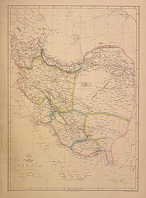
Persia
WELLER, Edward
Published by Day & Son, London, 1863
Used
unbound
From
Argosy Book Store, ABAA, ILAB, New York, NY, U.S.A.
Seller rating 5 out of 5 stars
![]()
Heritage Bookseller
AbeBooks member since 1996
About this Item
Description:
Map. Engraving with original hand coloring. Image measures 17" x 12" This detailed map of Persia depicts the region between the Caspian Sea and the Persian Gulf. Hand colored to delineate regions and provinces, the map notes important cities, rivers, towns, mountains, deserts, and other topographical features throughout. Relief is depicted by hachure. Repair to lower left, otherwise in very good condition. Many place names noted in the Gulf including Bahrain and Oman Edward Weller (d. 1884) was a prolific publisher, cartographer and engraver based in London. He was a fellow of the Royal Geographical Society. Seller Inventory # 317840
Bibliographic Details
Title: Persia
Publisher: Day & Son, London
Publication Date: 1863
Binding: unbound
Top Search Results from the AbeBooks Marketplace
Persia
Used
Seller: Antiqua Print Gallery, London, United Kingdom
Seller rating 4 out of 5 stars
![]()
Condition: Good. PERSIA. Provinces. Iran. Includes Azerbaijan Kerman Laristan. WELLER 1863 map. Antique map with original outline colour; Engraved by Edwd. Weller (1863). 44.0 x 31.0cm, 17.25 x 12.25 inches. Condition: Good. The image shown may have been taken from a different example of this map than that which is offered for sale. The map you will receive is in good condition but there may be minor variations in the condition from that shown in the image. This map was coloured by hand at the time of publication, thus the colouration may vary slightly between different examples of the map; the colouring applied to the map you receive may differ slightly from that shown in the image. There is nothing printed on the reverse side, which is plain. Seller Inventory # P-8-010415
Quantity: 3 available

Seller Image
Regional Map, Provinces of Persia (1862 Cassell Engraving)
Published by
Cassell, UK, 1862
Used
Softcover
Seller: Maynard & Bradley, Leicester, United Kingdom
Seller rating 5 out of 5 stars
![]()
Softcover. Condition: Very Good. 1862. A clean and well-presented map, neatly trimmed at the outer edges to eliminate edge wear, no significant marks. Margins are a little browned, with a few small spots of foxing encroaching onto the printed image. A few very small nicks at the outer edges are repaired with conservation tape. Why on Amazon do most sellers not describe their actual book? Buy with confidence and support a genuine Independent Bricks & Mortar Real Bookshop. We are Maynard & Bradley CAMBO & PBFA(now lapsed) members here in Leicester City Centre. Size: 320 x 480 mm0. 1. Item Type: Book. Quantity Available: 1. Shipped Weight: Under 500 grams. Category: Geography & Maps; Britain/UK; 19th century; Inventory No: 43401. Seller Inventory # 43401
Quantity: 1 available
Seller Image
Regional Map of Persia (1862 Cassell Engraving)
Published by
Cassell, UK, 1862
Used
Softcover
Seller: Maynard & Bradley, Leicester, United Kingdom
Seller rating 5 out of 5 stars
![]()
Softcover. Condition: Very Good. 1862. A clean and well-presented map, neatly trimmed at the outer edges to eliminate edge wear, no significant marks. Margins are a little browned, with a few small spots of foxing encroaching onto the printed image. A few very small nicks at the outer edges are repaired with conservation tape. Why on Amazon do most sellers not describe their actual book? Buy with confidence and support a genuine Independent Bricks & Mortar Real Bookshop. We are Maynard & Bradley CAMBO & PBFA(now lapsed) members here in Leicester City Centre. Size: 330 x 455. mm. 1. Item Type: Book. Quantity Available: 1. Shipped Weight: Under 500 grams. Category: Geography & Maps; Britain/UK; 19th century; Inventory No: 43378. Seller Inventory # 43378
Quantity: 1 available
Seller Image
Persia, Afghanistan, and Beloochistan
Used
Seller: Antiqua Print Gallery, London, United Kingdom
Seller rating 4 out of 5 stars
![]()
Condition: Good. Persia, Afghanistan & Beloochistan. Iran Pakistan. SW Asia. WELLER 1860 map. Antique engraved atlas map with original hand colour/color; Edward Weller (1860). 37.0 x 53.0cm, 14.5 x 20.75 inches; this is a folding map. Condition: Good. There is nothing printed on the reverse side, which is plain. Seller Inventory # P-7-026869
Quantity: 1 available
Seller Image
Persia, Afghanistan, and Beloochistan
Used
Seller: Antiqua Print Gallery, London, United Kingdom
Seller rating 4 out of 5 stars
![]()
Condition: Good. Persia, Afghanistan & Beloochistan. Iran Pakistan. SW Asia. WELLER 1860 map. Antique engraved atlas map with original hand colour/color; Edward Weller (1860). 37.0 x 53.0cm, 14.5 x 20.75 inches; this is a folding map. Condition: Good. There is nothing printed on the reverse side, which is plain. Seller Inventory # P-7-026777
Quantity: 1 available
Seller Image
Persia.
Published by
LondonPublished at the "Weekly Dispatch" Office ., 1863
Used
Seller: Robert Frew Ltd. ABA ILAB, London, United Kingdom
Seller rating 4 out of 5 stars
![]()
Original lithographed map. Map dimensions 43 x 30 , overall sheet size 48 x 34 cm. Original outline colour. Overall very good condition. Seller Inventory # 56529
Quantity: 1 available
Seller Image
Persia. [Map].
Published by
Cassell, Petter and Galpin. [circa1863]., London., 1863
Used
Seller: Asia Bookroom ANZAAB/ILAB, Canberra, ACT, Australia
Seller rating 5 out of 5 stars
![]()
Engraved map 43.1 x 30.3 cm, 50.7 x 34.5 cm (sheet) , central fold, small edge tears (one neatly repaired), lower corner chipped, slight age toning, but in very good condition. Impressive large map of Persia (Iran) by noted map maker Edward Weller in original uncoloured state, re-issued by the publisher for inclusion as map 26 in Cassell's Atlas. Seller Inventory # 177017
Quantity: 1 available
Seller Image
Persia, Afghanistan and Beloochistan.
Published by
Glasgow Edinburgh & LondonBlackie & Son c., 1882
Used
Seller: Robert Frew Ltd. ABA ILAB, London, United Kingdom
Seller rating 4 out of 5 stars
![]()
Original colour-printed map (34.5 x 50 cm) centred on present day Iran and adjacent countries. Showing major towns and cities, rivers, mountain ranges and borders. Centrefold crease as issued. Generally an excellent copy. Seller Inventory # 62053
Quantity: 1 available