
Historical Map of Scotland
BULLOCK, L.G.
Published by John Bartholomew & Son, Ltd, Edinburgh, 1969
Used
hardcover
From
Argosy Book Store, ABAA, ILAB, New York, NY, U.S.A.
Seller rating 5 out of 5 stars
![]()
Heritage Bookseller
AbeBooks member since 1996
This specific copy is no longer available. Here are our closest matches for Historical Map of Scotland by BULLOCK, L.G..
About this Item
Description:
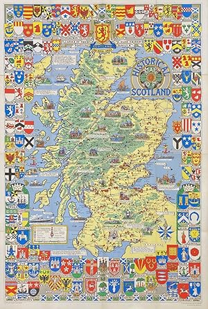
Map. Color lithograph. Measures 37 3/4" x 25" This vibrant pictorial map of Scotland was printed in 1969. The map depicts towns, roads, cathedrals, abbeys, royal burghs, ancient Roman sites, castles, resorts, and seaports. Sites of major battles and sieges, and massacres are indicated by year. Pictorial details illustrate Scottish figures, historical events, customs, and traditions. Various quotes, aphorisms, and inscriptions are superimposed throughout. Surrounding the map is a decorative border featuring heraldic symbols. In very good condition, with minor toning to margins and along some folds. Folded as issued. Leslie George Bullock (1895-1971) was an English writer, civil servant, and cartographer. He produced his first map in 1937 for John Bartholomew & Son, Ltd - a pictorial guide for the Empire Exhibition, Scotland held in Glasgow in 1938. He continued to design pictorial maps for the publishing house for the next three decades. He is best remembered for his playful and decorative style, annotated with informative details and references. John Bartholomew (1831-1893) was a Scottish cartographer known throughout Great Britain for his finely produced maps, often in color. This map is a fine example of his work. Seller Inventory # 316377
Bibliographic Details
Title: Historical Map of Scotland
Publisher: John Bartholomew & Son, Ltd, Edinburgh
Publication Date: 1969
Binding: hardcover
Top Search Results from the AbeBooks Marketplace

Historical Map of Scotland
Published by
John Bartholomew & Son Ltd., Great Britain
Used
Soft cover
Seller: George Strange's Bookmart, Brandon, MB, Canada
Seller rating 5 out of 5 stars
![]()
Soft cover. Condition: Very Good. A foldout map of Scotland in good condition. Seller Inventory # 005268
Historical Map of Scotland - 16 folded pages
Published by
John Bartholomew & Son Ltd, Edinburgh, Scotland
Used
Soft cover
Seller: G W Jackson, St.Marys, ON, Canada
Seller rating 3 out of 5 stars
![]()
Soft cover. Condition: Very Good. No Jacket. Illustrated (illustrator). Unfolded, this map measures 39 x 26 inches. Seller Inventory # CLTL4A36

Stock Image
Historical Map of Scotland
Seller: Brit Books, Milton Keynes, United Kingdom
Seller rating 4 out of 5 stars
![]()
Map. Condition: Used; Good. ***Simply Brit*** Welcome to our online used book store, where affordability meets great quality. Dive into a world of captivating reads without breaking the bank. We take pride in offering a wide selection of used books, from classics to hidden gems, ensuring there is something for every literary palate. All orders are shipped within 24 hours and our lightning fast-delivery within 48 hours coupled with our prompt customer service ensures a smooth journey from ordering to delivery. Discover the joy of reading with us, your trusted source for affordable books that do not compromise on quality. Seller Inventory # 3010377
Buy Used
� 8.99
� 15.99 shipping
Ships from United Kingdom to U.S.A.
Ships from United Kingdom to U.S.A.
Quantity: 1 available
HISTORICAL MAP OF SCOTLAND
Published by
JOHN BARTHOLOMEW & SON LTD, EDINBURGH
Used
Soft cover
Seller: COOK AND BAKERS BOOKS, PARKSVILLE, VANCOUVER ISLAND, BC, Canada
Seller rating 5 out of 5 stars
![]()
Soft cover. Condition: Very Good. Price sticker scar on front cover of map. Folded size: 4.5 X 8.5" un-folded: 26" wide X 37" tall. Printed on Cloth - Revised in 1952. Shows: Cathedrals & Abbeys; Battles & Massacres; Castles & Resorts; Towns, Ports, Roads; Scenic & Historic Features. Decorated with the clan Coats of Arms. Seller Inventory # 578894
Seller Image
Historical Map of Scotland:
Published by
Bartholomew UNBEKANNT., 1945
ISBN 10: 0851525687
ISBN 13: 9780851525686
Used
Broschiert, Karte
Seller: ANTIQUARIAT F�RDEBUCH Inh.Michael Simon, Eckernf�rde, Germany
Seller rating 5 out of 5 stars
![]()
Broschiert, Karte. Condition: Gut. Auflage: Illustrated. Karte guter Zustand, Einband leicht berieben, engl sprachig LIEFERZEITEN / DELIVERY TIMES: DEUTSCHLAND 5 - 14 Tage EUROPA/EUROPE: 7 - 30 Tage/Days USA/WELTWEIT/WORLDWIDE: 14 - 60 Tage/Days (!!!) +++ Sprache: Englisch Gewicht in Gramm: 450. Seller Inventory # 344128
Historical Map of Scotland
Published by
John Bartholomew
Used
Map
Seller: High Street Books, New Mills, United Kingdom
Seller rating 5 out of 5 stars
![]()
Map. Condition: Fair. Covers stained and worn, cloth backed map has a few marks along the folds, undated. Shipped from the UK in recyclable card packaging. Seller Inventory # cb162-426-0149
Historical Map of SCOTLAND by L G Bullock 1969 - FULL COLOUR Cloth Map
Published by
John Bartholomews & Son Ltd, Edinburgh Scotland, 1969
Used
Soft cover
Seller: Artifacts eBookstore, Gosport, United Kingdom
Seller rating 5 out of 5 stars
![]()
Soft cover. Condition: Very Good. No Jacket. ## Historical Map of SCOTLAND by L G Bullock 1969 - FULL COLOUR Cloth Map ### 7 ## THIS MAP: Classified as VERY GOOD, it is the 1969 Edition. The map was first published in Great Britain in 1969. Printed in full colour, measuring 26� Inches by 30 inches (678cm x 762cm) ### We provide images to all our books and maps so you know what you buy. READ ON for more information and details. ## # ## The Historical Map of Scotland, created by L. G. Bullock in 1969, is a full-colour cloth map that is a treasure trove of historical and geographical insights, capturing Scotland's rich past and diverse landscapes. ### Overview: The Historical Map of Scotland is a visual masterpiece that unfolds Scotland's story across time and space. Here are the key features that make this map a must-have for history enthusiasts:## 1. Vivid Color Palette: - The map is a riot of colours, vividly portraying Scotland's varied regions, from the Highlands to the Lowlands. Each hue represents a different historical era, allowing viewers to trace the evolution of Scotland over centuries.## 2. Geographical Details: - The map meticulously outlines towns, roads, cathedrals, abbeys, royal burghs, and ancient Roman sites. Castles, resorts, and seaports dot the landscape, providing a glimpse into Scotland's architectural heritage.## 3. Historical Significance:- Major battles, sieges, and massacres are marked along with the corresponding years on the map. ## Imagine standing on the very ground where these pivotal events unfolded! ### Exploring the Map: 1. Towns and Cities:- Discover Scotland's bustling towns and cities, each with unique character and history. From Edinburgh's regal charm to Glasgow's industrial prowess, the map celebrates urban life.## 2. Ancient Sites:- Follow the ancient Roman roads and explore the remnants of their civilisation. Visit abbeys and cathedrals that have witnessed centuries of worship and cultural exchange.## 3. Castles and Strongholds:- Scotland is synonymous with castles, and this map highlights their strategic locations. Feel the echoes of medieval knights and noble families as you trace their ancestral homes.## 4. Battlefields and Sieges: - Stand where armies clashed, where freedom was won or lost. The map reveals the scars of conflict, reminding us of Scotland's resilience. ## ### Collector's Item: The Historical Map of Scotland is more than a navigational guide; it's a piece of art. Whether displayed on your study wall or carefully folded in a drawer, it invites you to explore Scotland's past and connect with its people.## ### Conclusion: L. G. Bullock's creation invites us to step back in time, traverse Scotland's rugged terrain, and immerse ourselves in its captivating history. Unfold this cloth map, and let its colours and contours transport you to a bygone era. ## ## INTERNATIONAL BUYERS: Please Note. FREE SHIPPING IS UK ONLY. Please get in touch with me for a shipping quotation. No Author signature. Seller Inventory # 2013-130-map
Buy Used
� 12.99
� 15 shipping
Ships from United Kingdom to U.S.A.
Ships from United Kingdom to U.S.A.
Quantity: 1 available
Seller Image
HISTORICAL MAP OF SCOTLAND
Seller: Herr Klaus Dieter Boettcher, Karlsruhe, BW, Germany
Seller rating 4 out of 5 stars
![]()
Softcover/Paperback. Condition: Gut. Very colourful, fold-out historical map of Scotland. Undated but probably 1980's? Size: 39 in. x 26 in. Sprache: Englisch Gewicht in Gramm: 550. Seller Inventory # 44591
Stock Image
Historical Map of Scotland
Seller: A Wigtown Book, Kirkinner, GALLO, United Kingdom
Seller rating 1 out of 5 stars
![]()
Seller Inventory # 11032504
Buy Used
� 15
� 4.10 shipping
Ships from United Kingdom to U.S.A.
Ships from United Kingdom to U.S.A.
Quantity: 1 available
Historical Map of Scotland
Published by
John Bartholomew & Son LTD, Edinburgh
Used
Paper
Seller: Lloyd Zimmer, Books and Maps, Chanute, KS, U.S.A.
Seller rating 5 out of 5 stars
![]()
Paper. Condition: Very Good. Dust Jacket Condition: No Dust Jacket. Bright and attractive, undated, folding map, circa 1950? Paper backed on linen, measuring 26 x 38 inches (66 x 97 cm). Previous owner's name is seen on the front panel. Otherwise a clean and intact copy. Seller Inventory # 038957