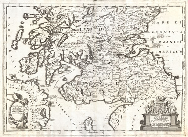
Scotia, Parte Meridionale .
1690 Coronelli Map of Southern Scotland (Edinburgh and Glasgow)
Publication Date: 1690
Used
From
Geographicus Rare Antique Maps, Brooklyn, NY, U.S.A.
Seller rating 3 out of 5 stars
![]()
AbeBooks Seller since 21 November 2024
This specific copy is no longer available. Here are our closest matches for Scotia, Parte Meridionale ..
About this Item
Description:
Very good. Some scuffing to covers, contents exhibit occasional wormholing. Binding tight. Size 18 x 25 Inches. This is Vincenzo Maria Coronelli's 1690 map of southern Scotland. Covers the southern part of Scotland from New Aberdone and Kiltre south as far as the Isle of Man, including adjacent parts of England and Ireland. The major cities of Glasgow and Edinburgh, among many others, are identified. As a whole this is a splendid example of Coronelli's distinctive style at its finest, with detailed engraving, historical notes, armorial vignettes, and an baroque title cartouche complete with a pedestal, the Scotch royal crest, and four Cherubim. Published for inclusion in Coronelli's stupendous 1690 Atlante Veneto . Seller Inventory # ScotiaParteMeridionale-coronelli-1690
Bibliographic Details
Title: Scotia, Parte Meridionale .
Publication Date: 1690
Top Search Results from the AbeBooks Marketplace

Seller Image
1690 Scotia, Parte Meridionale, Descritta, e Dedicata Dal P. Cosmografo Coronelli.
Used
Seller: New World Cartographic, Chicago, IL, U.S.A.
Seller rating 4 out of 5 stars
![]()
By: Vincenzo Maria CoronelliDate: 1690 (undated) VeniceDimensions: 18 x 24.5 inches (45.7 cm x 62.2)This magnificent Coronelli map of southern Scotland covers the southern part of Scotland from New Abderdone and Kiltre, and extends south as far as the Isle of Man, including adjacent parts of England and Ireland. Major cities such as Glasgow and Edinburgh are noted, as are countless smaller towns, cities, estates and manor houses.Topographical features are noted in profile, with high hills and mountains carefully charted. Aquatic features are noted including streams, rivers, lakes, gulfs and bays, inlets and ports. A lovely cartouche encloses the scale for the map, with distances denoted in Italian and Scottish 'miglia' and French and German 'leghe'. The title cartouche features cherubim on a Baroque pedestal, two of whom are holding the Scottish royal crest on top of which rests the Scottish crown.The map was published for the magnificent cosmographic atlas the Atlante Veneto, issued by the Jesuit friar, geographer and globe maker Coronelli. The work consists of thirteen volumes in four parts, includes 191 engraved charts and maps, and was conceived as a continuation of Blaeu's Atlas Major.Condition: This remarkable example of Coronellis map is in A condition. An intense impression printed on high quality heavy paper, with lovely hand colouring.Inventory #195761200 W. 35th Street #425 Chicago, IL 60609 | P: (312) 496 - 3622. Seller Inventory # antique-map-scotland-1690
Seller Image
Scotia parte meridionale descritta e dedicata�(con:) Parte settentrionale descritta e dedicata�
Published by
Venezia, 1690
Used
Seller: libreria antiquaria perini Sas di Perini, Verona, VR, Italy
Seller rating 5 out of 5 stars
![]()
Coppia di incisioni in rame, unite e dipinte a mano a formare una grande carta di mm 895x630, arricchita dai consueti ricchi cartigli, tipici del cartografo veneto. Tratta da "Corso geografico", senza testo al verso, (1688-92) una delle pi? celebri opere del vulcanico religioso veneziano, autore fra la fine del secolo e gli inizi del successivo di decine di importanti pubblicazioni fra cui ricordiamo il "Libro dei globi", oltre ai celebri globi costruiti per il re di Francia, "Teatro della guerra", "Atlante veneto" e "Teatro delle citt?". Bell'esemplare con margine sinistro breve, piccolo difetti ai margini. Couple of joined copper engravings, each mm 450x630 (total size mm 895x630) engraved in the typical flamboyant Coronelli's style, colored by hand. Nice example of Coronelli's 2 sheet map of Holland, including large cartouches and table of counties, towns, etc. Showns towns, mountains, rivers, lakes, islands, bays, churches and other features. One of the most decorative large format 17th Century maps of HollandFrom "Corso geografico" with no text on verso. The remarkable Vincenzo Coronelli (1650-1718), encyclopaedist, geographer, inventor and Doctor of Theology, was citizen of the Republic of Venice. He was also one of the most prominent mapmakers and publishers in Europe of his day. Vincenzo Coronelli, in addition to being an ordined Franciscan priest who eventually became Father General of his order, was also one of the most prominent mapmakers and publishers in Europe of his day. He was appointed official Cosmographer to the Venetian Republic in 1685, a year after he founded the world's earliest geographic society, "L'Accademia Cosmografica degli Argonauti" in the same city. A good example with minor marginal defects. Nr.cat: 6385. Seller Inventory # 12356
Scotia Parte Settentrionale/ Meridionale
Published by
Venice, 1690
Used
Seller: Bruce Marshall Rare Books, Cheltenham, United Kingdom
Seller rating 5 out of 5 stars
![]()
No Binding. Condition: Very Good. Two sheet map of Scotland, from Coronelli's 'Corso Geografico Universale', copper engraved, uncoloured, separate as issued, four large cartouches, two coat of arms, dedication to the theologist Tommaso Maria Peire, inset list of Scottish Counties, central vertical folding, Italian text of verso, each c.455 x 625mm, Venice, [c.1690] One of the most decorative large format maps of Scotland from the 17th Century. The detail shows mountains, lochs, rivers, islands, bays, towns and churches. Finely engraved in Coronelli's unique style. Coronelli (1650-1718), was a Franciscan Friar and appointed General of the Order in 1701. He was cosmographer to the Republic of Venice and founder of the Academia Cosmografica degli Argonauti, the world's first geographical society (1680). Seller Inventory # 6226
Buy Used
� 600
� 4.10 shipping
Ships from United Kingdom to U.S.A.
Ships from United Kingdom to U.S.A.
Quantity: 1 available
Seller Image
Kupferstich- Karte, in 2 Bll. (zusammensetzbar ) v. Coronelli aus "Atlante veneto", "Scotia Parte settentrionale ." und "Scotia, Parte Meridionale .".
Used
Seller: Antiquariat Clemens Paulusch GmbH, Berlin, Germany
Seller rating 5 out of 5 stars
![]()
um 1691, je 45 x 61 Die sch�ne Karte noch nicht zusammengesetzt. Die Karten jeweils mit einer Kartusche, das n�rdliche Blatt mit einer Einteilung des Landes, beide Karten in guten Abdrucken. Seller Inventory # 324470