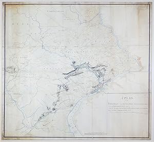
A Plan of the Progres of the Royal Army from their Landing at Elk Ferry to Philadelphia 1777 Under the Command of His Excellency, Sir William Howe Knight of the most Honorable Order of the Bath, Commander in Chief &ca &ca &ca Surveyd and Drawn by Order of Major General Sir William Erskine &c &c &c By Charles Blaskowitz, Capt of the Corps Guides

Published by [Philadelphia], 1778

  • First Edition
  • Signed
  • Map
  • Used
See all details
Item image 1 of 2.

Seller: Arader Books, New York, NY, U.S.A.Arader Books

5-star seller

AbeBooks seller since January 21, 2021

View this seller's items

Condition: Used - Very good

£ 1,923,164.50

 Free Shipping 
Ships within U.S.A.

Quantity: 1 available

Add to basket
Free 30-day returns

Item description from seller

ONE OF THREE SURVIVING HEADQUARTERS MAPS FOR THE PHILADELPHIA CAMPAIGN, AND THE ONLY ONE MADE DURING THE CAMPAIGN. Manuscript map at a scale of 2 miles to 1 inch. [Philadelphia, ca. 1778]. Twelve sheets joined (outer borders: 51 3/8" x 53 1/8", 1305mm x 1350mm). Black and sanguine ink, hand-colored. Mounted on linen. Framed to full museum specifications. Some peripheral soiling. Repairs to the joins and some edge-tears, including a small marginal loss. Early in the Revolutionary War, the Commander-in-Chief of the British land forces, General William Howe, believed that the capture of the young nation's capital, Philadelphia, would demoralize the rebels to the point of laying down their arms. It was with high hopes for victory in the war, then, that British forces under Howe landed at Elk Ferry (now Elkton, Maryland), south of Philadelphia, on August 25, 1777, with the goal of taking the capital and crushing the Continental Army commanded by George Washington. This manuscript map by Charles Blaskowitz (c.1743-1823), the preeminent surveyor of the British campaign, shows the movements of the British forces as they marched and fought their way from Elk Ferry towards Philadelphia, indicating with red lines the routes of the British troops under Howe, the British and Hessian troops under Charles Cornwallis, and the Hessian auxiliaries under Wilhelm von Knyphausen. Our map illustrates how vital cartography was to the waging of war. Blaskowitz, for example, marks the location of the cheveaux de frise that the American forces had set up in the Delaware River to prevent British ships from approaching Philadelphia; Washington used the same tactics in the Hudson, adding two huge chain booms. Other maps show some of these same things -- William Faden made a manuscript map in 1777 "exhibiting the several works erected by the rebels" in the river -- but our map is of signal historical importance for being one of just three surviving large-format "Headquarters Maps" from the Philadelphia Campaign, and the only one made during the campaign. Blaskowitz's map shows more detail, particularly of the road network, taverns, and meeting houses, than the two maps that he probably used as sources: Nicholas Scull and George Heap's map of Philadelphia and its surroundings, first published in 1752, and Scull's map of southeastern Pennsylvania of 1759. Blaskowitz's map includes a much larger area than that of the campaign proper. Compare, for instance, the map of the same campaign made by John André (Progress of the British Army from the landing in Elk River to the taking possession of Philadelphia, anno 1777: Huntington Library HM 3086r): it includes no more territory than necessary to show the route of the army to Philadelphia. Blaskowitz made his map for General Sir William Erskine (1728-1795), who participated in the Philadelphia Campaign, and for whom Blaskowitz has previously made a map of the New York Campaign in 1776 (Richard H. Brown Revolutionary War Map Collection at Mount Vernon). Usually in the eighteenth century the taking of an enemy's capital entailed the end of the war, but this was not the case after the British took Philadelphia. The Continental Congress had left the city for Lancaster before the British arrived, and in any case, the British capture of Philadelphia did not bring any important strategic advantages. In fact, Washington used the winter of 1777-78 to train the Continental Army into a much more expert fighting force. The high hopes that the British had for the Philadelphia Campaign when Blaskowitz began depicting it on his map were not achieved, and the war continued for another six years. Purchased at Christie's New York (7 December 2012, "Property of Mrs. M. Sharpe Erskine's Trust," lot 64). Catalogued by Mr. Chet van Duzer, revised by JL Rosenberg (D.Phil, Oxon.).

Seller Inventory # 6JLR0160

Bibliographic details

Title
A Plan of the Progres of the Royal Army from their Landing at Elk Ferry to Philadelphia 1777 Under the Command of His Excellency, Sir William Howe Knight of the most Honorable Order of the Bath, Commander in Chief &ca &ca &ca Surveyd and Drawn by Order of Major General Sir William Erskine &c &c &c By Charles Blaskowitz, Capt of the Corps Guides
Author
Blaskowitz, Charles
Publisher
[Philadelphia]
Publication year
1778
Condition
Very good
Signed
Signed by Author(s)
Binding
No binding
Edition
First.
Seller catalogs
Americana, Manuscript, Maps & Atlases

Arader Books

New York, NY, U.S.A.

5-star seller

AbeBooks seller since January 21, 2021

Shipping rates within U.S.A.

Item5 to 14 business days3 to 6 business days
First item£ 0.00£ 18.67
Delivery times are set by sellers and vary by carrier and location. Orders passing through Customs may face delays and buyers are responsible for any associated duties or fees. Sellers may contact you regarding additional charges to cover any increased costs to ship your items.

Payment methods

  • Visa
  • Mastercard
  • American Express
  • Apple Pay
  • Google Pay

Store description

Arader Galleries in New York City is one of the nation's foremost sellers of illustrated material from the sixteenth to the nineteenth centuries. Arader Books began in 2021 as a curated set of antiquarian books of the highest quality, specializing in atlases, voyages and natural history items -- especially plates of birds and flowers. Our shop is located at 1016 Madison Avenue (at East 79th Street) over six stories of a historic beaux-arts mansion. We welcome inquiries in-person, over the telephone or via e-mail.

Specialty

Plate Books, Natural History, Maps and Atlases, Voyages, Americana

Seller's business information

Arader Books

PA, U.S.A.