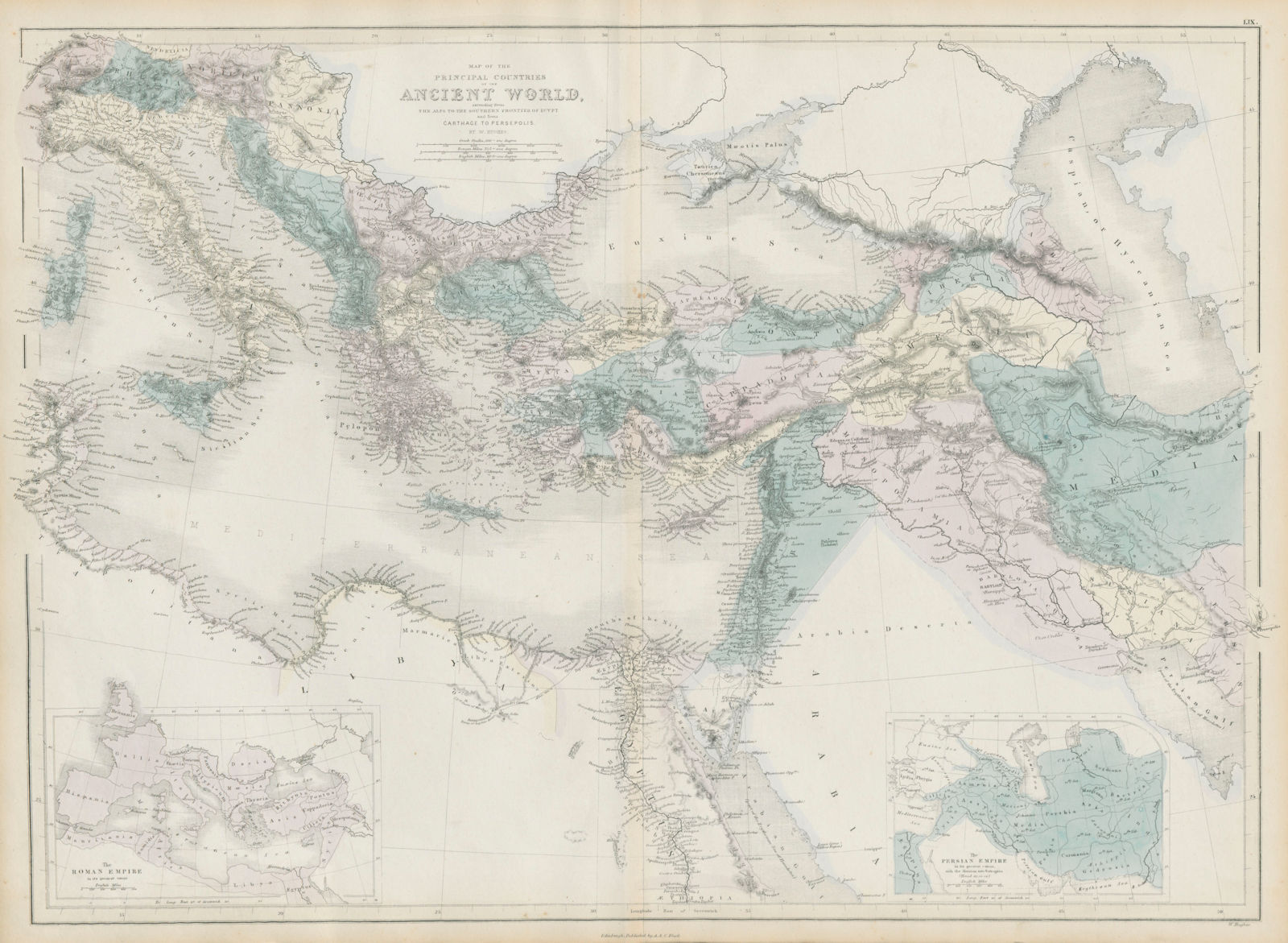
Map of the principal countries of the Ancient World extending from the Alps to the southern frontier of Egypt and from Carthage to Persepolis [Inset: the Roman Empire, the Persian Empire]
Hall, Sidney
Publication Date: 1856
Used
From
Antiqua Print Gallery, London, United Kingdom
Seller rating 5 out of 5 stars
![]()
AbeBooks Seller since 14 January 2022
This specific copy is no longer available. Here are our closest matches for Map of the principal countries of the Ancient World extending from the Alps to the southern frontier of Egypt and from Carthage to Persepolis [Inset: the Roman Empire, the Persian Empire] by Hall, Sidney.
About this Item
Description:
Countries of the Ancient World� from the Alps� to Persepolis. HUGHES 1856 map. Antique atlas map with original hand colouring / coloring; William Hughes (1856). 43.5 x 59.5cm, 17 x 23.5 inches; this is a folding map. Condition: Good. The image shown may have been taken from a different example of this map than that which is offered for sale. The map you will receive is in good condition but there may be minor variations in the condition from that shown in the image. This map was coloured by hand at the time of publication, thus the colouration may vary slightly between different examples of the map; the colouring applied to the map you receive may differ slightly from that shown in the image. There is nothing printed on the reverse side, which is plain. Seller Inventory # P-7-013725
Bibliographic Details
Title: Map of the principal countries of the ...
Publication Date: 1856
Condition: Good
Top Search Results from the AbeBooks Marketplace

Seller Image
Map of the principal countries of the Ancient World extending from the Alps to the southern frontier of Egypt and from Carthage to Persepolis [Inset: the Roman Empire, the Persian Empire]
Used
Seller: Antiqua Print Gallery, London, United Kingdom
Seller rating 4 out of 5 stars
![]()
Condition: Good. Countries of the Ancient World from the Alps to Persepolis. HUGHES 1854 map. Antique atlas map with original hand colouring / coloring; William Hughes (1854). 43.5 x 59.5cm, 17 x 23.5 inches; this is a folding map. Condition: Good. The image shown may have been taken from a different example of this map than that which is offered for sale. The map you will receive is in good condition but there may be minor variations in the condition from that shown in the image. This map was coloured by hand at the time of publication, thus the colouration may vary slightly between different examples of the map; the colouring applied to the map you receive may differ slightly from that shown in the image. There is nothing printed on the reverse side, which is plain. Seller Inventory # P-7-026718