About this Item
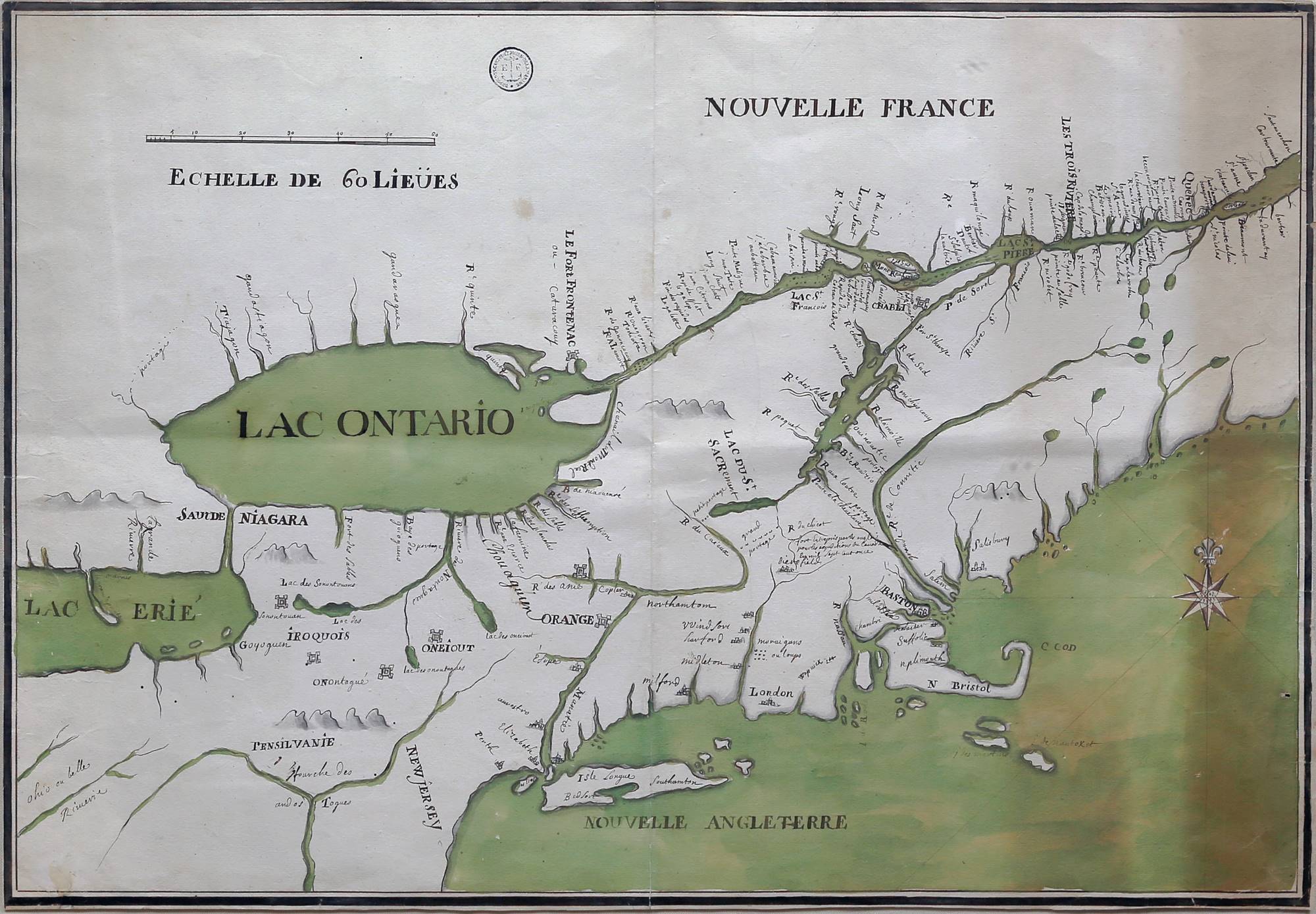
THE FIRST MAP OF AMERICA MADE BY AN AMERICAN IN AMERICA. [Quebec?: ca. 1711-1712.] Scale: approximately 20 miles to the inch. Single sheet (27 1/2" x 19"; 39" x 30 1/4" framed). Ink and watercolor. With a crease running up the middle. A tanned strip along the right-hand side. A little soiling around the extremities but otherwise fine. Inkstamp of the Dépôt des cartes, plans et journals de la Marine to the recto. Early ink manuscript on verso: "Carte Sous la Compagnie Des Indes Du Lac Champlain Et De Chouaquin" and docketing in a different hand: "N: 129- de la boîte/ No. 30./ Lac Ontario et pays des Iroquois./ Par . . . . . . . . . ." and "Amérique/ Canada". Conrad Heidenreich, professor emeritus of geography at York University in Toronto, has demonstrated (correspondence available) that this historic map is the work of the first American-born cartographer, Jean-Baptiste de Couagne (Decoüagne, de Couange; 1687-1740). A critical comparison is the map in the Bibliothčque nationale de France (FRBNF413961400000005), made for the Comte de Ponchartrain in 1711, which Couagne signs in the cartouche: "par son tres humble et tres obeissant serviteur Decoüagne." The nomenclature and hand-writing are very similar, and the variations suggest that our map -- which covers a much smaller area than the BnF map -- is a preparatory map for the great Ponchartrain map. Compare, for example, the note made just northwest of Boston (Baston) on our map: "fort Entrepris par les anglois/ pour les expeditions du Canada/ en mil sept cent once [sic]" and the corresponding note (in a much more epigraphic hand) on the BnF map: "Forts Entrepris Par Les Anglois/ En 1710 Pour L'expedition Du/ Canada." Note the change in number as well as of date. The Long Point of Lake Erie has been labeled "la grande pointe" on our map and in the BnF map "La Longue Pointe." These subtle shifts suggest an editorial process rather than mere copying. Mapping Nouvelle France and its relation to "Nouvelle Angleterre" speaks to the proxy war fought between France and England through its American colonial holdings. Understanding the terrain and the means of navigating it (principally by water; several "portages" are noted) was crucial to success. The French far surpassed the English in cartographic knowledge of this region until the efforts of Henry Popple (1733) and eventually Lewis Evans (1755). Couagne did not achieve a high rank in the French colonial regular army; he was made a half-pay captain in 1732, and a lieutenant before that in 1719. At the time of the maps' drafting, he was in the service of Gédéon de Catalogne, who was put in charge of mapping Canada's administrative districts and eventually went on to be a captain at Louisbourg (Île-Royale, current Cape Breton Island), where Couagne had gone in 1717 to assist in the development of the fortifications under Jean-François de Verville. The map made its way at some point to the Dépôt de la Marine (the stamp bears an "EF" flanking the anchor, indicating Empire Français (1804-1814/5)) in Marseilles, where it remained. In 1955, a major deaccession from the Dépôt de la Marine brought the map into a private collection, from which it was sold at Sotheby's London (12 June 2000, lot 207), after which it entered our collection. Six of Couagne's manuscript maps are held at the BnF and one by the Service historique de la défense (Bibliothčque Vincennes VI-R67, n° 13). Although some of Catalogne's maps were printed and published, Couagne's were not. Seller Inventory # 6JLR0161
Contact seller
Report this item

