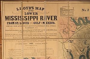
About this Item
Civil War Map. FIRST EDITION. (38.5 x 54.5 inches). Full Title:"Lloyd's map of the Lower Mississippi River from St. Louis to the Gulf of Mexico. Compiled from government surveys in the Topographical Bureau, Washington, D.C. Revised and corrected to the present time by Captains Bart and William Bowen, pilots of twenty years' experience on that River. Exhibiting the sugar and cotton plantations, cities, towns, landings, sand bars, islands, bluffs, bayous, cut-offs, the steamboat channel, mileage, fortifications, railroads. &c. along the River. J.T. Lloyd, Publisher. 164 Broadway, New York 1862. Entered . 1862, by J.T. Lloyd . New York." Pocket Edition with linen backs (folded dimension 8 x 5 inches). Lithograph map on five sheets joined, (37.25h x 51w) at line plus margins, hand colored, laid on linen, housed folded in the ORIGINAL marbled paper covered SLIPCASE with printed label. An exceedlingly SCARCE FIRST EDITION printing of Lloyd's richly informative strip map of the lower Mississippi River from St. Louis to its outlet in the Gulf of Mexico. A valuable record of the Southern plantation economy and the Steamboat age. The map is divided into 5 numbered strips, beginning with St. Louis at top left and ending with the Gulf of Mexico at bottom right. There is extensive detail of waterways, county and parish lines, roads and railroads, mines, forts, and towns of various sizes. Perhaps most importantly, however, are the names of landowners and the locations of their lots along the Mississippi River that are identified. Provenance: held in private family collection for generations, acquired from the Alga Schloss Estate. Alga's husband's first wife was a Morley of the Cleveland Morley Family, and a descendent of General G.W. Morgan. Map is clean with only light expected wear and toning. Stephenson 28, 41 (1862 and 1863 editions); Mapline 28; Modelski 139; Phillips Maps of America, p. 441.
Seller Inventory # 005181
Contact seller
Report this item