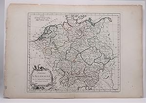
EMPIRE d'ALLEMAGNE
Vaugondy, Dirier Robert De
From Tennyson Williams Books and Fine Art, Williamsburg, VA, U.S.A.
Seller rating 4 out of 5 stars
AbeBooks Seller since 15 March 2018
From Tennyson Williams Books and Fine Art, Williamsburg, VA, U.S.A.
Seller rating 4 out of 5 stars
AbeBooks Seller since 15 March 2018
About this Item
The image is 9 3/8 inches by 11 inches on a folded sheet measuring 11 1/4 inches by 16 3/8 inches. Original hand-colored in outline map of the German Empire by Didier Robert de Vaugondy (circa 1723-1786). He and his father Gilles Robert de Vaugondy were the premier French cartographers of the 18th century. This map was published circa 1778 in Vaugondy's Atlas Portatif. The map is guaranteed to be more than 240 years old. It is in about very good condition: clean and bright, withjust s few small spots of foxing; edges of paper are tanning well away from the image; binding edge is rough. Size: 9 3/8 inches by 11 Inches. Seller Inventory # W2346
Bibliographic Details
Title: EMPIRE d'ALLEMAGNE
Publisher: Vaugondy, Paris
Publication Date: 1778
Binding: Single Sheet
Condition: Very Good-
Edition: First Edition Thus.
Book Type: Map
Store Description
Check with order, money order, Visa, Mastercard, American Express. Libraries
and dealers known to us net 30 days. Reciprocal courtesy to the trade.
Additional charge for shipping: $5.00 for first book USPS media mail, $1.50 each
additional book; $7.00 for first book priority mail, $2.00 each additional book.
Additional charge for very heavy books. All domestic shipments include delivery
confirmation. International clients should inquire about shipping charges.
Virginia customers will be invoiced...
Orders usually ship within 2 business days. Shipping costs are based on books weighing 2.2 LB, or 1 KG and small enough to fit in flat rate envelopes. If your book order is heavy or oversized, we may contact you to let you know extra shipping is required. Virginia customers will be invoiced for 6% sales tax.
Payment Methods
accepted by seller