
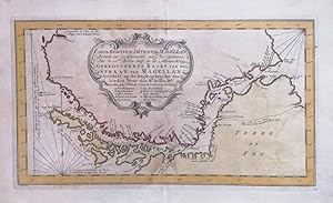
CARTE RÉDUITE DU DÉTROIT DE MAGELLAN
Bellin
Publication Date: 1753
Used
From
LUX IN ART di Ermanno Bertelli, Bologna, BO, Italy
Seller rating 5 out of 5 stars
![]()
AbeBooks Seller since 4 May 2020
This specific copy is no longer available. Here are our closest matches for CARTE RÉDUITE DU DÉTROIT DE MAGELLAN by Bellin.
About this Item
Description:
Incisione in rame. Tratta dal giornale dei navigatori descritta dall ingegnere della Marina, Bellin. Ottimo esemplare con bella coloritura d epoca. Formato: 195x345mm. Seller Inventory # CGT 19/25
Bibliographic Details
Title: CARTE RÉDUITE DU DÉTROIT DE MAGELLAN
Publication Date: 1753
Condition: ottimo
Top Search Results from the AbeBooks Marketplace

Seller Image
Carte reduite du Détroit de Magellan. [South America]
Published by
Paris: 1753, 1753
Used
Seller: Peter Harrington. ABA/ ILAB., London, United Kingdom
Seller rating 5 out of 5 stars
![]()
Interesting map of the Strait of Magellan in South America. Bellin was appointed hydrographer (chief cartographer) to the French navy upon the creation of France's hydrographic office, the Dépôt des cartes et plans de la Marine. As befits a maritime chart, all place names and general information is coastal, and there is no real attempt to engrave anything of note inland of the coastal areas. Over a 50-year career, he produced a large number of maps and charts. The accuracy of Bellin's charts ensured that they were in use for many years. Size: 250 x 410 mm. Copper engraving. Very good condition. Seller Inventory # 77823
Buy Used
Ł 120
Ł 22 shipping
Ships from United Kingdom to U.S.A.
Ships from United Kingdom to U.S.A.
Quantity: 1 available

Carte Reduite Du Detroit De Magellan
Published by
1762-1764., Paris, 1762
Used
Seller: Alexandre Antique Prints, Maps & Books, Toronto, ON, Canada
Seller rating 4 out of 5 stars
![]()
Condition: Very Good. Map of the Straits of Magellan.The Strait of Magellan is a sea route in southern Chile separating mainland South America to the north and Tierra del Fuego to the south. The strait is considered the most important natural passage between the Atlantic and Pacific oceans. It was discovered and first traversed by the Spanish expedition of Ferdinand Magellan in 1520, after whom it is named. , Size : 214x358 (mm), 8.43x14.09 (Inches), Hand Colored. Seller Inventory # M10900
Seller Image
Carte Réduite du Détroit de Magellan
Published by
Artist: Bellin Jacques Nicolas ( - 1772 ) Paris ca : 1753, 1703
Used
Seller: Antique Sommer& Sapunaru KG, München, Germany
Seller rating 4 out of 5 stars
![]()
Technic: Copper print, colorit: colored, condition: Perfect condition, size (in cm): 19 x 34,5, The striking map shows the Straits of Magellan with Argentinia and Fireland. Seller Inventory # AMS1147
Seller Image
Carte Reduite du Detroit de Magellan Dressee sur les Journaux des Navigateurs.
Used
Seller: Geographicus Rare Antique Maps, Brooklyn, NY, U.S.A.
Seller rating 4 out of 5 stars
![]()
Good. Original fold lines. Manuscript pagination in upper right margin. Mended tear along left border. Size 8.5 x 13.5 Inches. This is a beautiful 1753 Bellin map of the Straits of Magellan, South America. It covers the crucial strait located at the southern tip of the South American mainland, just north of Tierra del Fuego. The map extends from Cap des Vierges to Cap de la Victoire, rendering the region in detail, noting the coastlines, capes, harbors, islands and other important topographical features. Since its discovery by the Portuguese circumnavigator Ferdinand Magellin in 1520, this natural channel linked the Atlantic and Pacific Oceans despite the challenge in negotiating its unpredictable winds and currents. Until the construction of the Panama Canal it remained the fastest connection between the two oceans. The map is simply but elegantly engraved, with rhumb lines in the ocean areas; the one indicating north is marked with a fleur de lis. . Below the title, is a notation crediting the details of the map to a Mr. Labat, engineer accompanying Jacques Gouin de Beauchesne's 1699 voyage to the Pacific (the first French trading expedition to that ocean.) A key is included, identifying nine locations marked on the map. Publication History and Census This map was engraved in 1753 for inclusion in La Harpe's Abrégé de l'histoire générale des voyages . The separate map appears on the market from time to time, and in various editions appears in nineteen institutional collections. La Harpe's work is well represented in institutions. References: OCLC 163344058. Seller Inventory # DetroitDeMagellan-bellin-1780
Seller Image
Carte Reduite du Detroit de Magellan [Carta Reducida del Estrecho de Magallanes]
Published by
Paris, 1752
Used
Seller: Frame, Madrid, M, Spain
Seller rating 5 out of 5 stars
![]()
Condition: ACEPTABLE. [Un] Mapa, representando el Estrecho de Magallanes, obra del cartógrafo Jacques-Nicolas Bellin. Jacques-Nicolas Bellin (Paris, 1703 -Versailles, 1772) fue un geógrafo y cartógrafo francés de gran importancia para la historia de la cartografía. Fue Hidrógrafo en la Oficina Hidrográfica francesa, y miembro de la Académie de Marine y de la Royal Society de Londres. En 1721, a la edad de 18 ańos, fue nombrado hidrógrafo (cartógrafo jefe) de la Marina Militar francesa. En agosto del 1741, se convierte en el primer Ingénieur de la Marine del Depósito de mapas y planos de la Marina, y fue nombrado oficial hidrógrafico del rey de Francia. Produjo una considerable cantidad de gráficos y mapas, además de una serie de atlas de mares de todo el mundo. Estos mapas ganaron fama y respeto en toda Europa, por lo que fueron reeditados durante todo el siglo XVIII y también a lo largo del siglo XIX. Editóel "Petit Atlas Maritime" de 1764, con580 miniaturas finamente detalladas, al que pertenecería este mapa en concreto. La calidad y exactitud de su trabajo era tal que hizo ganar así a Francia un papel protagonista en la cartografía y geografía europeas. Sus obras: Hydrographie française (1753), Carte de l'Amérique septentrionale (1755), Le petit Atlas François-Recueil de Cartes et Plans des quatre parties du Monde (1758), Petit Atlas Maritime (1764), Nouvelle méthode pour apprendre la géographie (1769), Description géographique du golfe de Venise et de la Morée (1771). Título completo: "Carte Reduite du Detroit de Magellan Dressée sur les Journaux des Navigateurs, Par le S.r Bellin Ing. de la Mar. De la Societé Royale de Londres. 1753.". ["Dressée sur la Carte Espagnole du R.P. Murillo de Velarde, IreFeuille, Pour servir a l'Hitoire Generale des Voyages, Par le Sr. Bellin Ingr. de la Marine, 1752."] . Formato (cm): 19x34. Seller Inventory # 26639