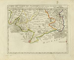
Antique Map-The province of Flanders in Belgium-Saint Amand-Douay-Vaugondy-1748
From ThePrintsCollector, Zeeland, Netherlands
Seller rating 5 out of 5 stars
AbeBooks Seller since 3 April 2017
From ThePrintsCollector, Zeeland, Netherlands
Seller rating 5 out of 5 stars
AbeBooks Seller since 3 April 2017
About this Item
Antique Map, titled: 'Carte de comte de Flandre ou sont les environs de la Basée, de Douay, de St. Amand […].' - Map of a part of Flanders. Map of a part of Flanders. Flanders. From: 'Atlas Portatif universel et militaire.', by Robert de Vaugondy, 1748. Engraving on laid paper. Watermark: Grapes Published by 'The Vaugondy family'. Gilles Robert de Vaugondy (1688 - 1766), also known as Le Sieur or Monsieur Robert, and his son, Didier Robert de Vaugondy (c.1723 - 1786), were leading mapmakers in France during the 18th century. Very good, given age. Large margins. General age-related toning and/or occasional minor defects from handling. Please study scan carefully. The overall size is ca. 26.5 x 21.2 cm. The image size is ca. 22 x 17.9 cm. The overall size is ca. 10.4 x 8.3 inch. The image size is ca. 8.7 x 7 inch. Storage location: C4-15. Seller Inventory # 74424
Bibliographic Details
Title: Antique Map-The province of Flanders in ...
Publication Date: 1748
Condition: Very Good
Store Description
Payment Methods
accepted by seller