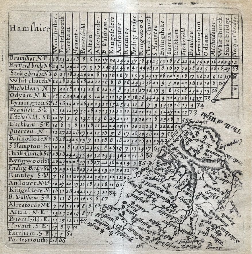
Lindisfarne Prints is a small family business specialising in genuine antique maps and prints at affordable prices. Established in 1995 and trading online since 2000, we pride ourselves on accurate descriptions, good communications, rapid service and fair prices. To avoid confusion, no item less than 100 years old is ever offered for sale. We do not deal in reproductions, facsimiles or modern copies of any kind.
So please buy with confidence in the safe knowledge that authenticity is unfailingly...
If you are a consumer you can withdraw from the contract in accordance with the following. Consumer means any natural person who is acting for purposes which are outside his trade, business, craft or profession.
Information regarding the right of withdrawal
Statutory right to withdraw
You have the right to withdraw from this contract within 14 days without giving any reason.
The withdrawal period will expire after 14 days from the day on which you acquire, or a third party other than the carrier and indicated by you acquires, physical possession of the last good or the last lot or piece.
To exercise the right of withdrawal, electronically fill in and submit a clear statement on our website, under "My Purchases" in "My Account". We will communicate to you an acknowledgement of receipt of such a withdrawal on a durable medium (e.g. by e-mail) without delay.
To meet the withdrawal deadline, it is sufficient for you to send your communication concerning your exercise of the right of withdrawal before the withdrawal period has expired.
Effects of withdrawal
If you withdraw from this contract, we will reimburse to you all payments received from you, including the costs of delivery (except for the supplementary costs arising if you chose a type of delivery other than the least expensive type of standard delivery offered by us).
We may make a deduction from the reimbursement for loss in value of any goods supplied, if the loss is the result of unnecessary handling by you.
We will make the reimbursement without undue delay, and not later than 14 days after the day on which we are informed about your decision to withdraw from this contract.
We will make the reimbursement using the same means of payment as you used for the initial transaction, unless you have expressly agreed otherwise; in any event, you will not incur any fees as a result of such reimbursement.
We may withhold reimbursement until we have received the goods back, or you have supplied evidence of having sent back the goods, whichever is the earliest.
You shall send back the goods or hand them over to Lindisfarne Prints, Shrewsbury, Shropshire, United Kingdom, +44 01743 213701, without undue delay and in any event not later than 14 days from the day on which you communicate your withdrawal from this contract to us. The deadline is met if you send back the goods before the period of 14 days has expired. You will have to bear the direct cost of returning the goods. You are only liable for any diminished value of the goods resulting from the handling other than what is necessary to establish the nature, characteristics and functioning of the goods.
Exceptions to the right of withdrawal
The right of withdrawal does not apply to:
- The delivery of newspapers, journals or magazines with the exception of subscription contracts; and
- The supply of digital content which is not supplied on a tangible medium (e.g. on a CD or DVD) if you accepted when you placed your order that we could start to deliver it, and that you could not withdraw once delivery had started.
