

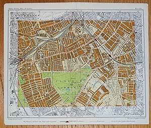
Antique Map CLAPHAM, BATTERSEA, BRIXTON, London street plan c1925
Used
From
Lindisfarne Prints, Shrewsbury, SHROP, United Kingdom
Seller rating 5 out of 5 stars
![]()
AbeBooks Seller since 29 August 2017
This book is no longer available. AbeBooks has millions of books. Please enter search terms below to find similar copies.
About this Item
Description:
�Antique Map �CLAPHAM, BATTERSEA, BRIXTON etc.�Published London circa 1925 by George Philip & Son�in "Philips' Handy Volume Atlas of London"�A highly detailed map divided into half mile squares, printed in colour.The level of detail can be appreciated from the close up image provided.Covers Clapham, Battersea, Stockwell, Brixton and more.All the streets and important places are named including Clapham Common, Lavender Hill, Wandsworth Road, Acre Lane, Landor Road, Kings Avenue, South Westminster Hospital, Battersea Rise, Clapham Station, Clapham Junction, Southern Railway works, Trinity Church etc etc.A fascinating record of London as it was 100 years ago before the ravages of WWII and the march of modern development.� Fine, clean condition. The map was printed in two seperate halves which have been conjoined with archival tape (neutral pH) on the back of the map. Due to inconsistencies of the printing process there may be some slight mis-register along the join. There are unrelated maps printed on the back.�Approx. 8" x� 7" (210mm x 180mm) overall.T531023. Seller Inventory # 24459
Bibliographic Details
Title: Antique Map CLAPHAM, BATTERSEA, BRIXTON, ...
AbeBooks offers millions of new, used, rare and out-of-print books, as well as cheap textbooks from thousands of booksellers around the world. Shopping on AbeBooks is easy, safe and 100% secure - search for your book, purchase a copy via our secure checkout and the bookseller ships it straight to you.
Search thousands of booksellers selling millions of new & used books
New & Used Books
New and used copies of new releases, best sellers and award winners. Save money with our huge selection.
Rare & Out of Print Books
From scarce first editions to sought-after signatures, find an array of rare, valuable and highly collectible books.