
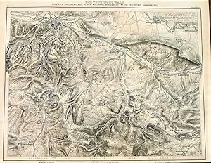
1867 Map of the Thuringian Forest, Eisenach, Wilhelmatstahl, Ruhla, Wartberg, Horselberg, Wutha, Wachstein, and Drachenstein. Numbers Indicate the Absolute Height in the River. By C. Vogel.
Petermann, A.
Published by Justus Perthes, Gotha, 1867
Language: German
Map
Condition: Used - Very good
Sold by Independent Books, Long Beach, WA, U.S.A.
AbeBooks Seller since 18 November 2004
Seller rating 4 out of 5 stars
![]()
Used
Condition: Used - Very good
Price:
� 40.69
Convert Currency
� 33.35
shipping from U.S.A. to United Kingdom
Destination, rates & speeds
Quantity: 1 available
Add to basket