
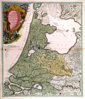
TABULA COMITATUS HOLLANDIAE. . Map of Holland, the northwest province of The Netherlands between North Sea, Zuyder Sea and the Waal, with Amsterdam in the centre. Large pictorial cartouche.
Homann Heirs.
Published by Homann Heirs 1733
Map
Condition: Used - Fine
Sold by Garwood & Voigt, Sevenoaks, United Kingdom
AbeBooks Seller since 25 November 2013
Seller rating 5 out of 5 stars
![]()
Used
Condition: Used - Fine
Price:
� 175
Convert Currency
� 40
shipping from United Kingdom to U.S.A.
Destination, rates & speeds
Quantity: 1 available
Add to basket