
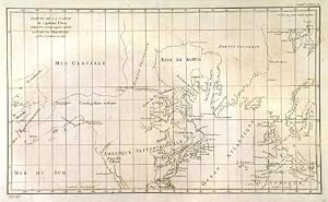
PARTIE DE LA CARTE DU CAPITAINE CLUNY AUTEUR D UN OUVRAGE ANGLOIS INTITUL� AMERICAN TRAVELLER PUBLI�E � LONDRES EN 1769 . Northern Western hemisphere on Mercator s projection showing North America and Europe and the supposed North-West passage between Hudson and Baffin Bay and the Arctic Ocean. A short R. de l Ouest (River) is indicated from the Californian coast inland.
(De Vaugondy, R.).
Published by Robert de Vaugondy after Cluny’s map of 1769, publ. in Diderot’s Encyclopaedia ca. 1773
Map
From Garwood & Voigt, Sevenoaks, United Kingdom
Seller rating 5 out of 5 stars
![]()
AbeBooks Seller since 25 November 2013