
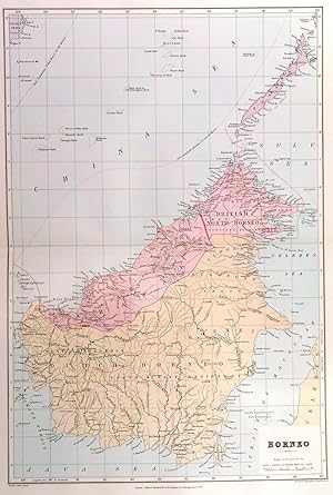
BORNEO . Large map of Borneo, showing Dutch and British Borneo, Sarawak and Brunei. The island of PALAWAN is now attributed to the USA. In addition, many overland and submarine telegraph lines are indicated. The provinces of British Borneo are separated by red lines . Railways are also beginning to show.
Edward Stanford.
Published by Edward Stanford ca. 1904
Map
Condition: Used - Fine
Sold by Garwood & Voigt, Sevenoaks, United Kingdom
AbeBooks Seller since 25 November 2013
Seller rating 5 out of 5 stars
![]()
Used
Condition: Used - Fine
Price:
� 90
Convert Currency
� 40
shipping from United Kingdom to U.S.A.
Destination, rates & speeds
Quantity: 1 available
Add to basket