About this Item
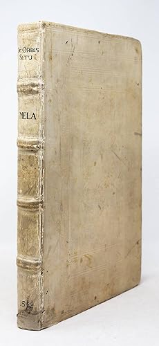
First edition. Basel: Andreas Cratander, 1522. Folio in 4s and 6s (11 15/16" x 7 3/4", 303mm x 197mm). [Full collation available.] With a folding woodcut map by Petrus Apianus (framed separately). Bound in contemporary paneled vellum over boards. On the spine, four raised bands. Title ink to the first panel, author gilt to second, date to fifth. Old repair to a loss at the tail. Superficial cracking to the hinges, and wear to the extremities, with soiling generally. End-papers renewed. Leaves a2-5 detached and laid in. Intermittent damp-staining at the lower edge, intensifying at the rear. Small marginal wormhole from Dd5-Gg6, not affecting the text. Scattered marginal splits and tears. On the title-page, the ink ownership of the Servitenkloster, Innsbruck ("Conventus S. Josephi Oenipontj"). Sporadic pencil foliation. Pomponius Mela (d. AD 45) was born hard by the Strait of Gibraltar; it is no accident that as a resident of the end of the known world, he was the first Roman geographer whose work survives. A frequent source of Pliny (whose Historia naturalis has geographical components but belongs properly to a different genre), Mela bridges the gap between the Greek geographers (Eratosthenes, Ptolemy) and his successors; his knowledge of the expanding Roman Empire in western and northern Europe surpasses that of his predecessors. Until Ptolemy was translated into Latin in 1406, it was the principal geographical work available in Europe. Although the first edited text appeared in 1518 (Vienna: Lucas Alantse and Johann Singriener) by Vadianus (van Watt, 1484-1551), this is the first with the participation of Johannes Camers (various names; he was born in Camerino and died in Vienna; 1468-1546), the Franciscan humanist. The map of Peter Apian (Petrus Apianus) had long been thought the earliest appearance of "America" -- i.e., South America -- on a map, but it has been antedated by WaldseemŘller's 1507 map Universalis Cosmographia, of which only one copy survives (in the Library of Congress; WaldseemŘller also made gores for a globe in the same year, which survive in a few more instances). It is nevertheless a tremendously important account of westward-expanding knowledge of the world. A great many copies of the Cratander De orbis situ were issued without the map, as it belongs properly with the 1520 Alantse/Singriener Polyhistor of Solinus. The Innsbruck Servitenkloster -- the mother monastery of the Servites in Austria -- amassed a vast library, which is now on permanent loan to Innsbruck University. It was founded in the 1610's, giving a terminus ante quem non for the ownership inscription. Purchased at Christie's London, 16 November 2005, lot 181. Adams M 1056; Shirley 45 (map); Burden, The Mapping of North America, p. xxv, pl. XII. Seller Inventory # JLR0237
Contact seller
Report this item
![]()


