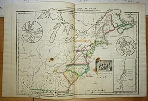
About this Item
Original publisher's hand-colored engraved map showing the eastern states and territories of the United States and the southeastern edge of Canada. No date, circa 1828. Paper with margins measures 16 3/4" x 11." Actual map area measures 9 1/2" x 14 1/2." Paper is very clean and intact except for a few spots. This map is from the first edition of Emma Willard's atlas titled, A Series of Maps of Willard's History of the United States, or, Republic of America. Pink, yellow, green, and blue watercolors highlight the state and territory boundaries. Louisiana (New Spain) is the westernmost portion. The easternmost is Nova Scotia. Also included is the Province of Maine. There are three inset maps; one shows "Charleston and Vicinity," another shows "Boston and Vicinity," and the last shows Lake George and surrounding area. Printed next the Lake George inset map is an illustration with the following caption: "A Committee of Five draw up the Declaration of Independence." Title is printed at the top along with the following: "To Accompany Willard's History of the United States." Printed at the bottom is the following: "Saml. Maverick Sc. N.Y." A few ships are shown depicting historical arrivals to the East Coast of the U.S., Nova Scotia, and Canada. Different geographic features include cities, rivers, and bays. Emma Willard (1787-1870) was a women's rights activist, educator, and cartographer. From an early age, Willard had a prowess for learning, academics, and teaching. Among Willard's major accomplishments was her founding of the first school for women's higher education, Troy Female Seminary, in 1821. Willard's school gave women opportunities to learn academic subjects that were typically reserved for men at the time, such as geography, history, philosophy, mathematics, and science. Troy Female Seminary is still open to this day in Troy, New York as the Emma Willard School (or simply, Emma) as a reputable and prestigious private school. Willard is also notable for being the first woman cartographer in the United States who worked in a professional capacity. Willard's approach to cartography was innovative in that she viewed mapmaking as a way to represent the relationship between historical events and philosophical concepts such as space, time, and memory. Samuel Maverick (1789-1845) came from a family of engravers and printers in New York. The work of the Mavericks was highly regarded and the family's printing tradition began with Peter Rushton Maverick (1755-1811). From the inception of Peter R. Maverick's career until about the mid-1800s, the Maverick name was synonymous engraving, lithography, and printing as a whole. Seller Inventory # 021719
Contact seller
Report this item