About this Item
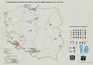
1st Edition. Original black printed portfolio, 8vo. Portfolio of seven large folding maps on on 4 sheets of heavy paper (3 are double sided, 1 is singled sided). Primarily black and white with some color. Text in Polish. Title translates to, "Nazi camps in Poland 1939 - 1945. An Encyclopaedic Reference Book: Maps." Collection of 7 maps, each 84 cm x 60 cm (33 x 24 inches), produced by Jan Laskowski at the Main Commission for the Investigation of Nazi Crimes in Poland. The maps comprise Volume II of the work; Volume I is a heavily illustrated 676-page book of the same title, which we offer separately. The Seven maps (all present) are: - Map 1 [Single Sided]: Hitlerowskie obozy na ziemiach polskich w latach 1939 - 1945. ["Nazi camps in Poland in the years 1939 - 1945"]. Showing: concentration and extermination camps, sub-camps of concentration camps, extermination centers, POW camps, more important sub-camps, working divisions, commandos and temporary POW camps, penal labor camps, major labor camps, prisons, transit camps & ghettos. - Map 2A: Getta na ziemiach polskich w okresie okupacji hitlerowskiej w latach 1939 - 1945 ["Ghettos in Poland during the Nazi occupation in 1939 - 1945"]. - Map 2B: Hitlerowskie obozy przejsciowe na ziemiach polskich w latach 1939 - 1945 ["Nazi transit camps in Poland in 1939-1945"]. - Map 3A: Hitlerowskie wiezienia i areszty na ziemiach polskich w latach 1939 - 1945 ["Nazi prisons and arrests in Poland in 1939 - 1945"]. - Map 3B: Hitlerowskie obozy pracy na ziemiach polskich w latach 1939 - 1945 ["Nazi labor camps in Poland in the years 1939 - 1945"]. - Map 4A: Hitlerowskie obozy jenieckie na ziemiach polskich w latach 1939 - 1945 ["Nazi POW camps in Poland in 1939 - 1945"]. - Map 4B: Hitlerowskie obozy koncentracyjne i osrodki zaglady na ziemiach polskich w latach 1939 - 1945 ["Nazi concentration camps and extermination centers in Poland in 1939 - 1945"]. Maps 2A & 2B have been described as a "Terrifying pair of maps showing the locations of German POW and internment camps in Poland during World War II, highlighting the widespread locations of these establishments. In some parts of the map, the information becomes so dense that three inset maps are shown. This map was designed by Jan Laskowski and printed in 1979 as part of a work on the Nazi extermination machine produced by PWN Warsaw, a state-owned research-focused publishing house in Poland. The map on the front is particularly interesting for its depiction of symbols used to classify internees in German camps. The uppermost of these depictions shows the combinations that can be made for different types of prisoners of different levels of importance. The armbands that would have been worn by these prisoners is shown, as well as the prison uniforms. Other details are also shown. The map lists hundreds of sites run by Nazi operators throughout the country. These include concentration camps, death camps, transitional camps, and ghettos. The map is divided according to Poland's voivodeships, with a key in the lower left. Names of cities too long to spell are also provided in the lower left. This map was produced during a point in Poland's history during which it was actively revisiting the period during the Second World War. Leading social scientists devoted their time to trying to gather all the living as well as the recorded history of the events of the Holocaust and related atrocities before this information vanished. Leading these efforts, particularly during the 1960s and 1970s, was the Gl�wna Komisja Scigania Zbrodni przeciwko Narodowi Polskiemu, known as the Chief Commission for the Prosecution of Crimes against the Polish Nation. They were active in publishing maps both for domestic educational purposes and for international remembrance and diplomatic efforts regarding the Holocaust. Jan Laskowski was a leading cartographer who produced a number of maps in this field. These maps were produced as part of a series of maps that purported to c.
Seller Inventory # 41929
Contact seller
Report this item


