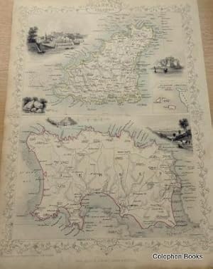
Map of Guernsey & Jersey.(Channel Islands).
John Tallis.
Sold by Colophon Books (UK), Leek, STAFF, United Kingdom
AbeBooks Seller since 2 January 2015
Used - No Binding
Condition: Used - Good
Quantity: 1 available
Add to basketSold by Colophon Books (UK), Leek, STAFF, United Kingdom
AbeBooks Seller since 2 January 2015
Condition: Used - Good
Quantity: 1 available
Add to basketPortrait format map of the two main channel islands Jersey and Guernsey. With 4 vignette steel engravings by E. Radclyffe. Inset map of all the islands. Outline coloured. Edges a bit thumbed and dusty at borders, ornate engraved borders. With a two page description of the history, population etc, of the Islands. Measures: 36 x 26.5 cm approx. Good to Very good. 1851.
Seller Inventory # 3151
We guarantee the condition of every book as it's described on the AbeBooks web sites. If you're dissatisfied with your purchase (Incorrect Book/Not as Described/Damaged) or if the order hasn't arrived, you're eligible for a refund within 30 days of the estimated delivery date. If you've changed your mind about a book that you've ordered, please use the Ask bookseller a question link to contact us and we'll respond within 2 business days. This does not affect your statutory consumer rights includ...
Shipping costs are based on books weighing 2.2 LB, or 1 KG. If your book order is heavy or oversized, we may contact you to let you know extra shipping is required.
Order quantity | 7 to 20 business days | 7 to 20 business days |
---|---|---|
First item | £ 26.25 | £ 26.25 |
Delivery times are set by sellers and vary by carrier and location. Orders passing through Customs may face delays and buyers are responsible for any associated duties or fees. Sellers may contact you regarding additional charges to cover any increased costs to ship your items.