
Order Total (1 Item Items):
Shipping Destination:

Wiltshire by Walker (16 results)
Skip to main search results
Search filters
Product Type
- All Product Types
- Books (12)
- Magazines & Periodicals (No further results match this refinement)
- Comics (No further results match this refinement)
- Sheet Music (No further results match this refinement)
- Art, Prints & Posters (No further results match this refinement)
- Photographs (No further results match this refinement)
- Maps (4)
- Manuscripts & Paper Collectibles (No further results match this refinement)
Condition Learn more
- New (No further results match this refinement)
- As New, Fine or Near Fine (2)
- Very Good or Good (3)
- Fair or Poor (No further results match this refinement)
- As Described (11)
Binding
- All Bindings
- Hardcover (10)
- Softcover (No further results match this refinement)
Collectible Attributes
Language (2)
Free Shipping
Seller Location
Seller Rating
-

Walker's Wiltshire
Language: English
Published by Longman, Hurst, Rees, Orme, and Brown, 1846
Seller: Lazarus Books Limited, Blackpool, LANCS, United Kingdom
Seller rating 5 out of 5 stars

Hardcover. Condition: Good. No Jacket. Size 3.5" x 4.8" tall,black hardboard with title across the front,the pastedown has a list of other books in the series and also a table showing the distance in miles between the different towns around the country,the itself consists of large pull out map which is attached and part of the endpaper. Book Condition: Very Good, all colours very bright, each section of the map in fine condition. 420mm x 350 mm. Engraved map, hand-coloured in outline, dissected into 15 sheets and mounted on linen, folding into green cloth covers, original printed label. Price 2/6.
-

Grandad, Minety & Me: A Lifetime in a North Wiltshire Village - SIGNED COPY
Language: English
Publication Date: 2013
Seller: Hampstead Books, Haverfordwest, United Kingdom
Seller rating 5 out of 5 stars
Signed
Hardcover. Condition: Near Fine. Dust Jacket Condition: Very Good. SIGNED BY THE AUTHOR WITH INSCRIPTION. All about the Taylors of Minety. Minimal wear to boards, crease down first, blank end paper, pages are clean & bright, , binding is tight. Light wear to unclipped dust jacket includes some edge wear. Dispatched from the UK same or next working day. NB: Due to the utter stupidity of Brexit, parcels sent to the EU may incur customs charges. Signed by Author(s).
-
WILTSHIRE [Walkers Folding County Map]
Language: English
Published by Longman Rees Orme., London, 1840
Seller: THOMAS RARE BOOKS, Yaxley, SUFFOLK, United Kingdom
Seller rating 4 out of 5 stars

Cloth. Condition: V.g. 1st issue. WALKERS COUNTY MAP SERIES. nd [C1840]. Origina green boards with the original label with an attractive border. Folding map of Wiltshire laid on linen and folded into 15 sections. Out-line hand-colour, coloured woods and railway lines. An attractive travellers map in a v.g. condition. 41 x 34cms.Parliamentary divisions updated in 1830. Please email for photos.
-
Wiltshire. [ Folding Map ]
Published by Longman, Rees, Orme, Brown & Co, London, 1836
Seller: Clarendon Books P.B.F.A., Leicester, United Kingdom
Association Member: PBFA
Seller rating 5 out of 5 stars
Hard Cover. Condition: Very Good. Original cloth covers, paper label, not dated c1836. 1pp of statistics, folding map on 15 sections, 17 x 14 inches, hand coloured, linen backed paper, a little browning in places, previous owners name in the margin, a bright example.
-

Single sheet. Original careful wash and outline hand-colouring of the Hundreds and Boroughs. Good margins all round. 32 x 39 cm.
-
Walker's Wiltshire [Walkers Folding County Map]
Published by Longman, Rees, Orme. Brown & Co., London, 1841
Map
Hardcover. Condition: Fair to Very Good. Undated c 1841.Handy pocket Folding Map, Hardback binding. Condition; good, front cover has some water marks to base, detached, Title to front. The hand coloured Map is on Linen and in very good condition, 2 small corner tip folding, owner stamp of the 'General health Board of Health & Nov. 17 1845' . Sectioned into15 sheets and mounted on linen. Size when open 42 x 34cm. Approx, Size closed 12.5 x 9.5cm. Approx. Extra info inside front cover inc population of market towns in 1841, distances between the towns.
-
Examples of Gothic architecture Volume 3: The Manor House at South Wraxhall and the Church of Saint Peter at Biddestone, Wiltshire
Published by Bohn, London, 1938
Seller: Mullen Books, ABAA, Marietta, PA, U.S.A.
Seller rating 4 out of 5 stars
Hardcover. Volume 3 only. Green cloth with leather cornes and spine. Spine is banded with gilt lettering. Top edge gold gilt. [vi],23pp, 22 plates, 2 folding pedigrees. This Volume 3 only. Contents: History and antiquities of the Vicars' Close, Wells, Somersetshire (London, 1836) -- History and antiquities of the Manor House and Church at Great Chalfield, Wiltshire (London, 1837) -- History and antiquities of the Manor House at South Wraxhall, and the Church of Saint Peter, at Biddestone, Wiltshire (London, 1838). The literary part by E.J. Willson. G, covers have separated from text block. Marbled end covers and flyleafs. Pages have slight to moderate foxing throughout but not extensive to any one page. This may have been rebound and can be easily repaired.
-
The History and Antiquities of the Manor House and Church at Great Chalfield, Wiltshire; the Property of Sir Harry Burrard Neale, illustrated by twenty-eight plates of plans, elevations, sections, parts at large, and perspective view; from sketches and admeasurements taken in 1836; forming part II. of "Examples of Gothic Architecture," third series.
Published by London: Printed for the Author, 1837
Seller: Forest Books, ABA-ILAB, Grantham, LINCS, United Kingdom
Association Member: ABA ILAB PBFA
Seller rating 5 out of 5 stars
First Edition
First edition, 4to (300 x 238 mm), [6], 26, [4]pp., 28 plates, some light foxing, front inner hinge shaken, orig. cloth-backed printed boards, a couple of small nicks to spine. Part two of the 3rd series of Pugin's Gothic Architecture, although complete in itself. Provenance: From the library of Josceline Grove, with bookplate and their typed catalogue description pasted to front endpapers. Holmes, p.114.
-

Original cloth folder with paper label on front. Dissected and linen backed. Very good condition with light wear. Outline color by borough. Lists towns with populations, as well as polling places, places of election . Railroads, roads and canals highlighted in color. Paste-down slip inside front cover lists towns with their populations, market days, and dates of fairs.
-
The History and Antiquities of the Manor House, at South Wraxhall, and the Church of Saint Peter, at Biddestone, Wiltshire; the former Property Walter Long, illustrated by twenty-two plates of plans, elevations, sections, parts at large, and perspective views, together with woodcuts; ; from sketches and admeasurements taken in 1837; forming part III. of "Examples of Gothic Architecture," third series.
Published by London: Printed for the Author, 1838
Seller: Forest Books, ABA-ILAB, Grantham, LINCS, United Kingdom
Association Member: ABA ILAB PBFA
Seller rating 5 out of 5 stars
First Edition
First edition, 4to (300 x 238 mm), [6], 28, [4]pp., 22 plates, some light foxing, orig. cloth-backed printed boards, a couple of small nicks to spine. Part three of the 3rd series of Pugin's Gothic Architecture, although complete in itself. Provenance: From the library of Josceline Grove, with bookplate and their typed catalogue description pasted to front endpapers. Holmes, p.233.
-
Walker?s Wiltshire Walker?s County Map of Wiltshire.
Published by London, J & C Walker, 1836, 1836
Seller: PROCTOR / THE ANTIQUE MAP & BOOKSHOP, DORCHESTER, United Kingdom
Association Member: PBFA
Seller rating 5 out of 5 stars
Dark green hardback cloth covers (3.5 x 5 ins.) with lettered label to front. Map folds out to 16.5 x 13.5 inches. Cut into sections and backed onto canvas. In very good condition. Cloth cover faded on spine, a couple of handling marks, small nicks to cloth on corners. Small previous owners inscription inside cover ?W. Blacke, Crewkerne.? Some minor tanning to map else clean and bright. Else a very good map with no tears. Fold out map, linen backed with hand colouring. The map shows towns, boroughs, villages, roads, and railways. No date but mentions number of MPs sent to parliament, which matches the situation pre the 1885 Reform Act.
-
Hardcover. 1st Edition. 42 x 35 cm. folding into 12.5 x 10 cm. covers. nd [1850]. A printed map of Wiltshire showing towns, roads, railways, with shading for hills, and listing the divisions established at the Quarter Sessions in1830, the Boroughs and the Polling Places; with the roads, railways and boundaries of the hunts hand coloured, and the names of the hunts overstamped: Vale of White Horse; Old Berkshire; Duke of Beaufort; Craven; Mr. T. A. Smith; South Wilts; Mr. Farquharson; New Forest. There is also a stamp "Lent by N.F.H. to Mr. T.A. Smith". The 15 sections of the map are mounted on linen. The map folds into case covered in red cloth with gilt lettering on the spine and front, and marbled paper inside. The map is clean. The covers are rubbed and spotted. The upper hinge is separated except for the top and bottom bands. The linen at the fold of the map meeting the edge of the lower cover is separated. The marbled paper is rubbed. No marks of ownership.
-
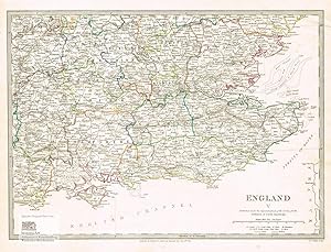
England V. Oxfordshire, Buckinghamshire, Hertfordshire, Essex, Middlesex, Berkshire, Wiltshire, Hampshire, Surrey, Kent, Sussex, Isle of Wight, London. Antique Map. Grenzkolorierter Original-Stahlstich von Walker bei Baldwin & Cradock 1830
Published by London: Baldwin & Cradock, 1830
Seller: historicArt Antiquariat & Kunsthandlung, Wiesbaden-Breckenheim, Germany
Seller rating 5 out of 5 stars
Map First Edition Signed
1. Original-Stahlstich von J. & C. Walker (in der Platte signiert) auf r�ckseitig unbedrucktem Blatt, von alter Hand grenzkoloriert, bildliche Darstellung ca. 27 x 37,5 cm, Blattgr��e ca. 34,5 x 41 cm, sauber und sehr gut erhalten 2100 gr.
-
1844 BEAUTIFUL Huge Color MAP of SouthWest England Wiltshire Great Britain ATLAS
Published by London : Published by the Society, and Chapman and Hall, 1844., 1844
Map First Edition
No Binding. Condition: Near Fine. 1st Edition. 1844 BEAUTIFUL Huge Color MAP of SouthWest England Wiltshire Great Britain ATLAS From "Society for Diffusion of Useful Knowledge" A beautifully hand-colored map from the 1844 printing of "Society for the Diffusion of Useful Knowledge" The Society for the Diffusion of Useful Knowledge (SDUK), founded in 1826, and wound up in 1848, was a Whiggish London organisation that published inexpensive texts intended to adapt scientific and similarly high-minded material for the rapidly expanding reading public. It was established mainly at the instigation of Lord Brougham with the objects of publishing information to people who were unable to obtain formal teaching, or who preferred self-education. Engraver: J & C Walker Atlas title: Maps of the Society for the Diffusion of Useful Knowledge. Map title: England IV, South-west, Cornwall to Wiltshire Published: London : Published by the Society, and Chapman and Hall, 1844. Language: English Notes & contents: Originally from the David Rumsey Collection FREE SHIPPING WORLDWIDE Wear: wear as seen in photos Publisher: London : Published by the Society, and Chapman and Hall, 1844. Size: ~13.5in X 16in (33cm x 41cm) Photos available upon request.
-

Wiltshire.
Published by London, 1835-. 395 x 325mm (15� x 12� inches)., 1835
Seller: Tooley, Adams & Co., Wallingford, OXON, United Kingdom
Seller rating 4 out of 5 stars
Original colour lithograph; fine condition. A detailed map of the county. Shows the places of the meeting of foxhounds and the areas are marked. From Hobson's Fox Hunting Atlas.
-

Wiltshire
Published by London. 1840, 1840
Seller: Peter Harrington. ABA/ ILAB., London, United Kingdom
Association Member: ABA ILAB PBFA
Seller rating 5 out of 5 stars
This is from a later edition of the Walker Brothers famous beautifully engraved The British Atlas of 1837. 'An interesting feature is that the maps were usually issued with all railways built marked in red by hand. Often these red railways are more extensive than lines actually engraved on the maps since old stock could be used up whilst still claiming that the maps contained the latest information.' David Smith Antique Maps of the British Isles p.213 Copper engraving. Fine condition, good margins. Original colour. Size: 32.2 x 38.8 cm.

![Seller image for Walker's Wiltshire [Walkers Folding County Map] for sale by Malcolm Books](https://pictures.abebooks.com/inventory/md/md31580028346.jpg)


