
Order Total (1 Item Items):
Shipping Destination:

The World on Mercator s Projection by Wyld James (5 results)
Feedback
Skip to main search results
Search filters
Product Type
- All Product Types
- Books (1)
- Magazines & Periodicals (No further results match this refinement)
- Comics (No further results match this refinement)
- Sheet Music (No further results match this refinement)
- Art, Prints & Posters (No further results match this refinement)
- Photographs (No further results match this refinement)
- Maps (4)
- Manuscripts & Paper Collectibles (No further results match this refinement)
Condition
- All Conditions
- New (No further results match this refinement)
- Used (5)
Binding
- All Bindings
- Hardcover (No further results match this refinement)
- Softcover (No further results match this refinement)
Collectible Attributes
- First Edition (No further results match this refinement)
- Signed (No further results match this refinement)
- Dust Jacket (No further results match this refinement)
- Seller-Supplied Images (5)
- Not Print on Demand (5)
Language (2)
Price
- Any Price
- Under � 20 (No further results match this refinement)
- � 20 to � 35 (No further results match this refinement)
- Over � 35
Free Shipping
- Free Shipping to United Kingdom (No further results match this refinement)
Seller Location
Seller Rating
-
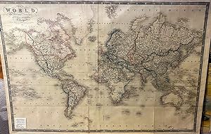
The World, on Mercators Projection
Published by James Wyld, London, 1841
Language: English
Seller: Anah Dunsheath RareBooks ABA ANZAAB ILAB, Auckland, NZ, New Zealand
Association Member: ABA ANZAAB ILAB
Seller rating 5 out of 5 stars

Map
� 822.66
Convert currency� 18.61 shipping from New Zealand to United KingdomQuantity: 1 available
Add to basketNo Binding. Condition: Very Good. Coloured engraving of a map of the world dedicated to the Queen early in Victoria's reign. With substantial geographic details labelled (including D'Urville and Wilkes discoveries of the Antarctic on the lower right, "New Zeeland"). James Wyld, a prolific publisher of maps, was official geographer to Queen Victoria and Prince Albert. Free on card 96 x 66 cm. Image shows wrinkles form the mylar cover. Very clean, Wyld map.
-
MAP of The World on Mercators Projection.
Published by J.Wyld No date Ca 1850, 1850
Seller: PROCTOR / THE ANTIQUE MAP & BOOKSHOP, DORCHESTER, United Kingdom
Association Member: PBFA
Seller rating 5 out of 5 stars
Large map ( ca 96cm x 63cm) backed on to linen. Folded into 8 vo sized slip-case. Map in very good condition. In good slip-case, faint mark top half & inscription on front paper label. Original colouring.
-

World on Mercator's Projection, Shewing the Distribution of Gold.
Published by James Wyld, Geographer to the Queen & H.R.H. Prince Albert. Model of the Earth Leicester Square, [c1851]., London,, 1851
Seller: Daniel Crouch Rare Books Ltd, London, United Kingdom
Association Member: ABA ILAB PBFA
Seller rating 4 out of 5 stars

Map
Unrecorded separate issue, and a possible prototype Lithographed pocket map folding into publisher's green cloth wallet, with circular printed paper label on both covers, uncoloured One of five maps issued with Wyld's very rare 'Gold Fields of Australia', also 1851, this is possibly a proof or prototype copy, for issue as a pocket map, with the deposits uncoloured. No other examples of a separate issue for this map are recorded. The imprint makes reference to Wyld's famous 'Great Globe', or 'Monster Globe', constructed to coincide with the Great Exhibition, which had rejected its inclusion on account of its vast size, of more than 60 feet in diameter. It was a popular attraction at Leicester Square between 1851 and 1862. Since it was hollow, and contained a staircase and elevated platforms, the public were able to climb up inside, and feel the interior surface of the earth, complete with mountains and rivers to scale. The front paste-down of the wallet gives a table of distances, and advertises Wyld's atlases and more manageable 12-inch globes; all of which were available at the attraction at Leicester Square. James Wyld (1812-1887) was "the most important mapmaker producing maps of London in the year of the Great Exhibition". Wyld was a highly successful publisher, MP for Bodmin, and an active figure in public life. He promoted the development of the British Library and campaigned for the Public Libraries and Museums Bill, accusing its agricultural opponents of trying to make the poor drink instead of read in order to keep malt consumption high; although he did oppose the introduction of the Ordnance Survey on behalf of private surveyors. Like his father, he was made Geographer to Queen Victoria and Prince Albert in 1836. He built his business on his ability to produce maps quickly in reaction to new discoveries and information: Punch remarked drily that if a country were discovered in the centre of the earth then Wyld would have a new map out "as soon as it is discovered, if not before". Rare: no other recorded examples found. Provenance: with the contemporary library label of "Milton, Peterborough".
-
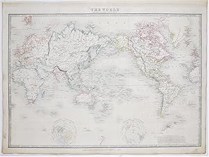
The World on Mercators Projection.
Published by LondonJames Wyld. Geographer to the Queen 457 Strand & 11 & 12 Charing Cross London. c., 1870
Seller: Robert Frew Ltd. ABA ILAB, London, United Kingdom
Association Member: ABA ILAB PBFA
Seller rating 4 out of 5 stars
Map
Single sheet (43 x 58 cm.) engraved map with 2 inset maps of Northern and Southern hemisphere. Original outline colour. British empire marked in red. Very good.
-
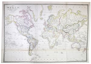
The World, on Mercators Projection.
Published by LondonJames Wyld., 1853
Seller: Robert Frew Ltd. ABA ILAB, London, United Kingdom
Association Member: ABA ILAB PBFA
Seller rating 4 out of 5 stars
Map
Original hand-coloured engraved map (63 x 92 cm. overall sheet size 68 x 97) Original outline colour. Two main vertical fold marks, bottom 15 cm. section on a separate conjoined sheet. Some minor light spotting towards lower portions, generally very good.
