Order Total (1 Item Items):
Shipping Destination:

The Smaller Islands in the British Ocean (14 results)
Feedback
Skip to main search results
Search filters
Product Type
- All Product Types
- Books (7)
- Magazines & Periodicals (No further results match this refinement)
- Comics (No further results match this refinement)
- Sheet Music (No further results match this refinement)
- Art, Prints & Posters (No further results match this refinement)
- Photographs (No further results match this refinement)
- Maps (7)
- Manuscripts & Paper Collectibles (No further results match this refinement)
Condition
- All Conditions
- New (No further results match this refinement)
- Used (14)
Binding
- All Bindings
- Hardcover (1)
- Softcover (No further results match this refinement)
Collectible Attributes
- First Edition (1)
- Signed (No further results match this refinement)
- Dust Jacket (No further results match this refinement)
- Seller-Supplied Images (13)
- Not Print on Demand (14)
Language (2)
Free Shipping
- Free Shipping to United Kingdom (No further results match this refinement)
Seller Location
Seller Rating
-

The smaller Islands of the British Ocean.
Published by London, c.1720. 120 x 120mm (4� x 4� inches)., 1720
Seller: Tooley, Adams & Co., Wallingford, OXON, United Kingdom
Seller rating 5 out of 5 stars

Uncoloured; light age-toning and minor nicks to margins, otherwise fine condition. A miniature map showing the Isles of Wight, Man, Holy, Guernsey, Alderney and Jersey from the 'Britannia Depicta or Ogilby Improved' by John Owen and Emanuel Bowen. The verso has the road from Harley in Shropshire to Welshpool.
-
Miniature Antique county map: THE SMALLER ISLANDS IN THE BRITISH OCEAN: Isle of Wight. Guernsey. Jersey. Isle of Scilly. Arne Island. Isle of Man. Alderney. Holy Island. From: BRITANNIA DEPICTA. or ?Ogilby Improv'd?.
Published by 1720, 1720
Seller: PROCTOR / THE ANTIQUE MAP & BOOKSHOP, DORCHESTER, United Kingdom
Association Member: PBFA
Seller rating 5 out of 5 stars
Wooden frame with glass front, In ivory mount with gold line. Engraved surface of map: ca 11 cm & 18 cm. Overall size including mount: ca. 23 cm x 31.5 cm. Frame Size 37cm x 30cm With later professional hand-colouring. Very good condition. Very lightly tanned. Decorative and finely engraved cartouche above the county map. Underneath the map: details of the county, size, climate, industry & commerce. With black & white strip road map on verso of map: Shrewsbury - Welchpool (Shropshire / Montgomeryshire ). Page 127 & 128 from ?Brittania Depicta? - ?Emanuel Bowen was one of the most skilled and prolific engravers of 18th. century. It was an unusual feature of his ?Britannia Depicta? atlas that the maps were engraved on both sides of each page. The maps can be double glazed, thus the customer has a choice of two maps. The publisher of the Atlas was a John Owen, hence the term ?Owen and Bowen? to describe maps from the work. The appreciation rate of this series of maps over the past 20 years has been remarkable? (J.Booth: Looking at old maps).
-
The Smaller Islands in the British Ocean [Isle of Wight, Scilly Isles, Guernsey, Jersey, Lindisfarne, Alderney, Isle of Man]
Publication Date: 1753
Map
Condition: Good. 'Smaller Islands in the British Ocean' Isle of Wight Man Scilly. BOWEN 1753 map. Antique copperplate map; John Owen & Emmanuel Bowen (1753). 12.5 x 19.0cm, 5 x 7.5 inches. Condition: Good. The image shown may have been taken from a different example of this map than that which is offered for sale. The map you will receive is in good condition but there may be minor variations in the condition from that shown in the image. This sheet is printed on both sides of the page. Plate number 128 is shown. Plate number 127: [Harley-Shrewsbury-Welshpool] is printed on the reverse side. The printing on the reverse side may show through to the front to some extent. The Road from London to Southampton : plate 1 of 3: The Smaller Islands in the British Ocean.
-

Ireland, and the smaller Islands in the British Ocean.
Published by London: Georgii Bishop & Ioannis Norton, 1610
First Edition
Hardcover. Condition: Good. 1st Edition. Folio, 310 x 192mm, half-title of sorts lettered as above with 55 as the page number, 61-233, [234] pp. Modern tan three-quarter calf, brown cloth, gilt on black lettering piece. Light water staining throughout, some annotations and highlights mostly smudged by the damp, lacks the map of Ireland otherwise a sound reading copy very nicely bound. Contains 'The Annals of Ireland' from page 149 to 200 and The Smaller Islands in the British Ocean from page 201 to 233 including 'A Chronicle of the Kings of Man'. First edition in English and translated by Philemon Holland and "revised, amended and enlarged with sundry additions" by Camden. Generous fore-edges thus the printed margin comments are intact.
-

The Smaller Islands in the British Ocean.
Published by London, c.1720. 175 x 225mm (7 x 8� inches)., 1720
Seller: Tooley, Adams & Co., Wallingford, OXON, United Kingdom
Seller rating 5 out of 5 stars
Uncoloured; very light age-toning to the edges of the paper, otherwise a fine examplle. Eight maps on one sheet, showing; Isle of Wight, Alderney, Farne, Holy, Isle of Man, Scilly Isles, Jersey and Guernsey. Published in Thomas Cox's 'Magna Britannia'.
-
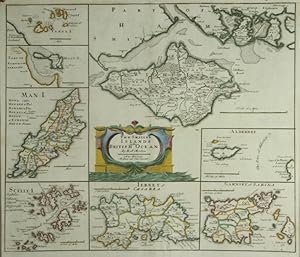
The Smaller Islands in the British Ocean. Isle of Wight, Alderney, Garnsey & Sarina, Jersey, Scilly, Isle of Man, Holy Island, Farne Islands.
Published by Abel Swale. Avenham and John Churchill. Ca 1695, 1695
Seller: PROCTOR / THE ANTIQUE MAP & BOOKSHOP, DORCHESTER, United Kingdom
Association Member: PBFA
Seller rating 5 out of 5 stars
Size 16.5 x 14.0 inches. In Black and gilt glazed wood frame. Overall size 17.5 x 15.0 inches. In very good condition. Slight vertical crease. Mild foxing. Else a clean and bright copy. Original engraved map with later hand colouring. A map of the Islands around Britain. Each island, or group, is shown in separate box. Islands shown are Wight, Farne, Holy Island, Man, Scilly, Jersey, Garnsey (sic), Alderney. Administrative divisions are shown with rivers towns, villages and nearby small islands. Man and Scilly have list of alternate names. Scales vary.
-

The Smaller Islands in the British Ocean.
Published by London, 1695. 360 x 420mm (14� x 16� inches)., 1695
Seller: Tooley, Adams & Co., Wallingford, OXON, United Kingdom
Seller rating 5 out of 5 stars
Uncoloured; very light marginal spotting fine dark impression. The islands shown are: Wight, Alderney, Guernsey, Jersey, Scilly Isles, Man, Holy Island and Farne. Complete with the relevant pages of text on the section from the atlas.
-
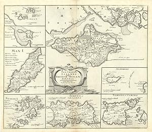
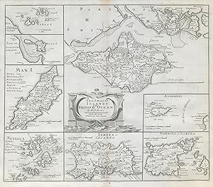
The Smaller Islands of the British Ocean // Wight // Farne // Holy I. // Man // Scilly // Jersey or Caesarea // Alderney // Garnsey or Sarina
Publication Date: 1722
Map
Condition: Good. ENGLAND. Isles of Wight/Man Scilly Isles Farne/Channel Islands. MORDEN 1722 map. Double page folio copperplate engraved map; Robert Morden; "Sold by Abel Swale Awnsham & Iohn Churchill [John Churchill]". (From Gibson's English version of Camden's Britannia, originally published in 1695; This print from the second 1722 edition). 39.5 x 45.5cm, 15.5 x 17.75 inches; this is a folding map. Condition: Good. The image shown may have been taken from a different example of this map than that which is offered for sale. The map you will receive is in good condition but there may be minor variations in the condition from that shown in the image. There is nothing printed on the reverse side, which is plain.
-
The Smaller Islands of the British Ocean // Wight // Farne // Holy I. // Man // Scilly // Jersey or Caesarea // Alderney // Garnsey or Sarina
Publication Date: 1722
Map
Condition: Good. ENGLAND. Isles of Wight/Man Scilly Isles Farne/Channel Islands. MORDEN 1722 map. Double page folio copperplate engraved map; Robert Morden; "Sold by Abel Swale Awnsham & Iohn Churchill [John Churchill]". (From Gibson's English version of Camden's Britannia, originally published in 1695; This print from the second 1722 edition). 39.5 x 45.5cm, 15.5 x 17.75 inches; this is a folding map. Condition: Good. There is nothing printed on the reverse side, which is plain.
-

The smaller islands in the British ocean
Published by sold by Abel Swale, Awnsham and John Churchill, n.d., [London], 1722
Seller: Rulon-Miller Books (ABAA / ILAB), St. Paul, MN, U.S.A.
Association Member: ABAA ILAB RMABA
Seller rating 5 out of 5 stars
� 166.64
Convert currency� 54.73 shipping from U.S.A. to United KingdomQuantity: 1 available
Add to basketEngraved map approx. 15�" x 17�", old central fold; near fine. Originally made by Robert Morden (ca. 1650-1703), an English bookseller and publisher, as well as an accomplished geographer and cartographer. He is best known for a series of maps in Gibson's revised edition of Camden's Brittannia, engraved by Sutton Nichols in about 1695. This map includes 8 inset maps of Farne, Holy, Man, Scilly, Jersey, Garnsey (i.e., Guernsey, including Sark), Alderney, and a larger one of the Isle of Wight.
-
The Smaller Islands in the British Ocean.
Published by LondonAbel Swale Awnsham & John Churchill., 1695
Seller: Robert Frew Ltd. ABA ILAB, London, United Kingdom
Association Member: ABA ILAB PBFA
Seller rating 4 out of 5 stars

Map
Overall image size 35.5 x 41.8 cm. Eight maps of varying dimensions on one double page sheet, comprising maps of the Isle of Wight, Alderney, Guernesey (including Sark), Jersey, the Isles of Scilly, the Isle of Man, Holy Island and the Farne Islands. Orginal outline colour to the maps, also orginal colour to the central title cartouche. Blank on verso. A few small areas of offsetting from original colour. Upper margin expertly restored (the engraved area unaffected), otherwise in very good condition.
-

Kupferstich- Karte, n. Rob. Morden aus Camdens Britannica, "The Smaller Islands in the British Ocean".
Language: German
Seller: Antiquariat Clemens Paulusch GmbH, Berlin, Germany
Seller rating 5 out of 5 stars
Map
� 201.20
Convert currency� 13.02 shipping from Germany to United KingdomQuantity: 1 available
Add to basketmit altem Grenzkolorit, 1695, 25,5 x 42 Mittig die Titelkartusche. - Auf dem Blatt 8 kleine Karten der Insel Wight, Alderney, Garnsey, Iersey, Scilly - islands, Insel man, Holy islands und Farne Islands. 2 Papierausrisse im breiten wei�en Rand restauriert.
-
Condition: Good. ENGLAND. Isles of Wight/Man Scilly Isles Farne/Channel Islands. MORDEN 1753 map. Double page folio copperplate engraved map; Robert Morden; "Sold by Abel Swale Awnsham & Iohn Churchill [John Churchill]". (1753). 39.5 x 45.5cm, 15.5 x 17.75 inches; this is a folding map. Condition: Good. There is a light damp stain in the bottom margin extending slightly inside the border, and a pair of small wormholes near the bottom either side of the fold. There is nothing printed on the reverse side, which is plain.
-

THE SMALLER ISLANDS IN THE BRITISH OCEAN.
Seller: Graham York Rare Books ABA ILAB, Honiton, United Kingdom
Association Member: ABA ILAB PBFA
Seller rating 5 out of 5 stars
Map
Condition: Very good. 1695 or later, sold by Abel Swale Awnsham and John Churchill, 45cm x 39cm, hand-coloured.

![Seller image for The Smaller Islands in the British Ocean [Isle of Wight, Scilly Isles, Guernsey, Jersey, Lindisfarne, Alderney, Isle of Man] for sale by Antiqua Print Gallery](https://pictures.abebooks.com/inventory/md/md31106567098.jpg)