
Order Total (1 Item Items):
Shipping Destination:

Sumatra Java by W G Blackie (1 results)
Skip to main search results
Search filters
Product Type
- All Product Types
- Books (1)
- Magazines & Periodicals (No further results match this refinement)
- Comics (No further results match this refinement)
- Sheet Music (No further results match this refinement)
- Art, Prints & Posters (No further results match this refinement)
- Photographs (No further results match this refinement)
- Maps (No further results match this refinement)
- Manuscripts & Paper Collectibles (No further results match this refinement)
Condition Learn more
- New (No further results match this refinement)
- As New, Fine or Near Fine (No further results match this refinement)
- Very Good or Good (No further results match this refinement)
- Fair or Poor (No further results match this refinement)
- As Described (1)
Binding
- All Bindings
- Hardcover (No further results match this refinement)
- Softcover (No further results match this refinement)
Collectible Attributes
- First Edition (No further results match this refinement)
- Signed (No further results match this refinement)
- Dust Jacket (No further results match this refinement)
- Seller-Supplied Images (1)
- Not Print on Demand (1)
Language (1)
Price
- Any Price
- Under � 20 (No further results match this refinement)
- � 20 to � 35
- Over � 35 (No further results match this refinement)
Free Shipping
- Free Shipping to U.S.A. (No further results match this refinement)
Seller Location
Seller Rating
-
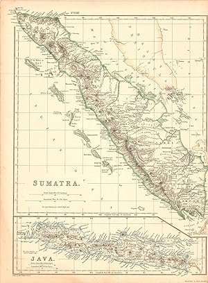
Sumatra / Java
Publication Date: 1860
Seller: Art Source International Inc., Boulder, CO, U.S.A.
Seller rating 5 out of 5 stars

This map was made by W.G Blackie, Ph.D in 1860 for The Imperial Atlas of Modern Geography; An Extensive Series of Maps. Sumatra and Java are illustrated on this sheet. Original hand colored outlining and exquisite detailing make this a wonderful map for framing. This map measures 10 inches by 13.5 inches.