Statistical Map Australia by Letts (3 results)

Published by 1881. Each 17.25in x 14in (44 x 36cm), 1881
- Map
Seller: R.G. Watkins Books and Prints, Ilminster, SOMER, United KingdomR.G. Watkins Books and Prints
Contact seller4-star sellerCondition: Used - Very good
£ 15.00
£ 28.00 shippingShips from United Kingdom to U.S.A.Quantity: 1 available
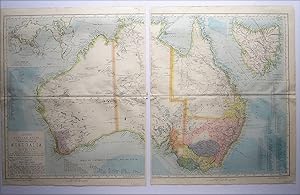
Add to basketNo Binding. Condition: Very good. Dust Jacket Condition: No Jacket issued. Colour maps, from Letts's "Popular Atlas", showing boundaries. central fold, tear in top and bottom border.
 More images
Published by 1881. Each 17.25in x 14in (44 x 36cm), 1881
- Map
Seller: R.G. Watkins Books and Prints, Ilminster, SOMER, United KingdomR.G. Watkins Books and Prints
Contact seller4-star sellerCondition: Used - Very good
£ 50.00
£ 28.00 shippingShips from United Kingdom to U.S.A.Quantity: 1 available
Add to basketNo Binding. Condition: Very good. Dust Jacket Condition: No Jacket issued. Colour maps, from Letts's "Popular Atlas", showing boundaries. central fold, three maps joined along fold.
 More images
Published by Letts, Son & Ltd., London, 1881
- Map
Seller: Angelika C. J. Friebe Ltd. - MapWoman, Dorking, United KingdomAngelika C. J. Friebe Ltd. - MapWoman
Contact seller5-star sellerCondition: Used - Near fine
£ 100.00
£ 20.00 shippingShips from United Kingdom to U.S.A.Quantity: 1 available
Add to basketNo Binding. Condition: Near Fine. colour printed map on two sheets, not joined; overall 44 x 72 cm, image overall 40 x 68 cm. folds as issued; one split to centrefold; o/w exc. cond. A large map of Australia with insets of Tasmania and the World from Letts' Popular Atlas. The coloured areas show the settled territories, divided…into counties. It also shows the areas good for livestock and agriculture.


