
Order Total (1 Item Items):
Shipping Destination:

State by Connecticut Map (4 results)
Skip to main search results
Search filters
Product Type
- All Product Types
- Books (No further results match this refinement)
- Magazines & Periodicals (No further results match this refinement)
- Comics (No further results match this refinement)
- Sheet Music (No further results match this refinement)
- Art, Prints & Posters (No further results match this refinement)
- Photographs (No further results match this refinement)
- Maps (4)
- Manuscripts & Paper Collectibles (No further results match this refinement)
Condition Learn more
- New (No further results match this refinement)
- As New, Fine or Near Fine (No further results match this refinement)
- Very Good or Good (1)
- Fair or Poor (No further results match this refinement)
- As Described (3)
Binding
- All Bindings
- Hardcover (No further results match this refinement)
- Softcover (No further results match this refinement)
Collectible Attributes
- First Edition (2)
- Signed (No further results match this refinement)
- Dust Jacket (No further results match this refinement)
- Seller-Supplied Images (4)
- Not Print on Demand (4)
Language (1)
Price
- Any Price
- Under � 20 (No further results match this refinement)
- � 20 to � 40 (No further results match this refinement)
- Over � 40
Free Shipping
Seller Location
Seller Rating
-
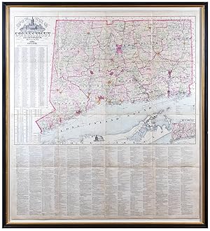
No binding. Condition: Very good. One sheet (52" x 46 3/4" sheet, 57 5/8" x 51 3/4" framed). Hand-colored lithograph, mounted on linen. Mild scattered foxing. Slight toning and tearing around the center fold. James Botsford Beers (1811-1901) of the J.B Beers & Co. map publishing firm was born in Connecticut and began publishing maps and county atlases around 1870. J.B. was the patriarch of the Beers family of map publishers; both his son Frederick W. Beers and his distant cousin John Hobart Beers also published maps and atlases. J.B. Beers published more than 150 county and city atlases and about sixty maps that were offered for sale by the firm. Although he published maps of the whole of the United States, Connecticut was doubtless a special interest, as he was born and buried in Newtown. The map includes a table giving the population as of 1800 and dates of settlement or organization of towns, arranged by Senatorial district, as well as a table giving 1870 and 1880 populations for counties, arranged by Congressional district.
-

Clark and Tackabury's New Topographical Map of the State of Connecticut.
Publication Date: 1859
Seller: Geographicus Rare Antique Maps, Brooklyn, NY, U.S.A.
Association Member: ABAA ESA ILAB
Seller rating 4 out of 5 stars

Map
Good. Professionally restored and backed with fresh linen. Original rollers. Part of top border missing - see image. Measurement includes rollers. Size 57 x 73 Inches. A 1859 first-edition example of Richard Clark and Robert and George Tackabury's important wall map of Connecticut. When published, it was by far the best and largest map of the state obtainable. A Closer Look The map covers the entire state of Connecticut with impressive detail, including topography, color coding by county and township, notes on railroad lines, rivers, and roads, and countless depth soundings along the Long Island Sound. There are multiple insets of Connecticut cities. Drawn on a scale of 1.5 miles to the inch, Clark and Tackabury's map purports to be the most complete map of Connecticut ever published, identifying 'the location of all public buildings, churches, school-houses, manufacturing establishments, and private residences'. Nine insets focus on the cities of Norwalk, New London, Bridgeport, Hartford, Norwich, Middleton, Waterbury, Norwich, Waterbury, Stamford, and New Haven, where Yale College is identified. To the left of the map proper are 1850 census population statistics for both counties and cities arrayed in a table. Publication History and Census The cartography is an amalgam of older maps and new private survey work produced by G. M. Hopkins and Company of Philadelphia. The countless depth soundings along the Long Island Sound are drawn from the U.S. Coast Survey. This is one of the last great wall maps of Connecticut in the 19th-century. It was printed in Philadelphia and sold by subscription in both wall and case format from March 2, 1859. References: Thompson, E., Maps of Connecticut for the Years of the Industrial Revolution, #181.
-
Clark and Tackabury's New Topographical Map of the State of Connecticut.
Publication Date: 1859
Seller: Geographicus Rare Antique Maps, Brooklyn, NY, U.S.A.
Association Member: ABAA ESA ILAB
Seller rating 4 out of 5 stars
Map First Edition
1st Edition. Good. Original linen backing stable. Overall toning. Some surface abrasion and edge wear. Some dampstaining. Custom clamshell box. Size 57 x 72 Inches. An attractive 1859 first edition example of Richard Clark and Robert and George Tackabury's important wall map of Connecticut. Drawn on a scale of 1.5 miles to the inch, this is the largest and most complete map of Connecticut to appear in the 19th century. A Closer Look The map covers Connecticut with detail including topography by hachure, color coding by county and township, notes on railroad lines, rivers, and roads, and countless depth soundings. It identifies 'the location of all public buildings, churches, school-houses, manufacturing establishments, and private residences'. Nine insets focus on the cities of Norwalk, New London, Bridgeport, Hartford, Norwich, Middleton, Waterbury, Norwich, Waterbury, Stamford and New Haven, where Yale College is identified. To the left of the map proper are 1850 census population statistics for both counties and cities arrayed in a table. Sources Cartographically this map is an amalgam of older maps and new private survey work ordered by G. M Hopkins and Company of Philadelphia. The countless depth soundings along the Long Island Sound are drawn from the U.S. Coast Survey. Publication History and Census This map was prepared by Robert M. and George N. Tackabury based upon surveys performed by G. M. Hopkins. It was published by Clark and Tackabury, and printed in Philadelphia by Thomas S. Wagner Lithography. It was sold by subscription in both wall and case format from March 2, 1859. The first edition of this map is scarce - especially as here in dissected format. We note examples of this edition at 4 institutions: Yale University Library, the Connecticut Historical Society, the University of Connecticut, and the Boston Athenaeum. Scarce to the market. References: OCLC 806491344. Thompson, E., Maps of Connecticut for the Years of the Industrial Revolution, #181.
-

The State of Connecticut Including Parts of New York and New Jersey.
Publication Date: 1852
Seller: Geographicus Rare Antique Maps, Brooklyn, NY, U.S.A.
Association Member: ABAA ESA ILAB
Seller rating 4 out of 5 stars
Map First Edition
1st Edition. Very good. Wear and light toning along original fold lines. Areas of reinforcement along left side where previously attached to binder. Accompanied by original binder. Size 22.75 x 28.25 Inches. This is a strikingly vivid 1852 example of Roderick Nevers' map of Connecticut, Long Island, and eastern New York - published in Hartford. The map focuses on Connecticut, but emphasizes its connections to New York City via railroads in Connecticut, the Hudson Valley, and Long Island. A Railroad Map To produce this map, Roderick updated William Damerum's excellent map, retooling it to emphasize Connecticut's burgeoning railroad network. Among the railroads present are the New York and New Haven; the New Haven, Hartford, and Springfield; and the Norwich and Worcester. The Hartford, Providence and Fishkill Railroad also appears, along with its proposed route west of Hartford to Fishkill, where it was to meet the Hudson River Railroad. In New York, the Hudson River Railroad runs from Manhattan north to Redhook Landing. The Long Island Railroad stretches across Long Island from Brooklyn to Greenport. Even More Detail Townships are highlighted with vivid wash color. The same level of detail does not translate to eastern New York, where the colors differentiate more generally between counties rather than townships. Towns and villages are labeled along the Hudson, along with other locations such as the U.S. Military Academy at West Point. Topography is loosely rendered with visual depictions of mountains. Publication History and Census This 1852 map was published in Hartford by Roderick Nevers. Per Rumsey, First edition was 1851, a reissue of Damerum's 1815 map. The sixteen stars that surround the eagle in the cartouche stand for the sixteen states in the union when Damerum's plate was engraved by Peter Maverick in 1815, whose plate has been reengraved to produce the map. Stebbins in 1859 produced a map that follows this plate closely. Many changes have been made to the original plate to bring it up to date, particularly the delineation of railroads. While the original Maverick plate would have been in copper or steel, it is likely that this edition was transferred to lithographic stone - as was common in the 1850s. Scarce. We note three examples in OCLC: New York Public Library, the Connecticut Historical Society, and the Connecticut State Library. An example is also part of the David Rumsey Map Collection. Limited market history. References: Rumsey 2562.002. OCLC 20254230.
