
Order Total (1 Item Items):
Shipping Destination:

Stanfords Map British Metropolis Suburbs by Stanford Edward (2 results)
Feedback
Skip to main search results
Search filters
Product Type
- All Product Types
- Books (1)
- Magazines & Periodicals (No further results match this refinement)
- Comics (No further results match this refinement)
- Sheet Music (No further results match this refinement)
- Art, Prints & Posters (No further results match this refinement)
- Photographs (No further results match this refinement)
- Maps (1)
- Manuscripts & Paper Collectibles (No further results match this refinement)
Condition Learn more
- New (No further results match this refinement)
- As New, Fine or Near Fine (No further results match this refinement)
- Very Good or Good (1)
- Fair or Poor (No further results match this refinement)
- As Described (1)
Binding
- All Bindings
- Hardcover (1)
- Softcover (No further results match this refinement)
Collectible Attributes
- First Edition (No further results match this refinement)
- Signed (No further results match this refinement)
- Dust Jacket (No further results match this refinement)
- Seller-Supplied Images (2)
- Not Print on Demand (2)
Language (2)
Price
- Any Price
- Under � 20 (No further results match this refinement)
- � 20 to � 35 (No further results match this refinement)
- Over � 35
Free Shipping
- Free Shipping to United Kingdom (No further results match this refinement)
Seller Location
Seller Rating
-

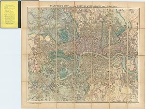
Stanford's Map Of The British Metropolis And Suburbs - London
Published by Edward Stanford, London, UK, 1887
Language: English
No Binding. Condition: Good. New edition. Publisher: Edward Stanford. Price: �300. Publication Date: May 2nd, 1887. Edition: New edition. Format: Original engraving with hand-colouring. Scale: circa 3 inches to 1 mile. Condition: In good condition, unframed. Sheet Size: 70.1cm x 83.9cm when opened. Condition: A detailed map of London with original hand-colouring on a scale of three inches to one mile. Dissected on linen on 28 folds. Lacks the front board. Slight wear along original folds with splits to the linen on two sections. Map with bright original colour and nice and clean with very minor age-toning and marks. Overall in good, bright, clean condition and highly suitable for framing. Scarce. Stanford's Map Of The British Metropolis And Suburbs: A Brief Description: Stanford's Map of the British Metropolis and Suburbs at a scale of 3 inches to one mile is one of the most and detailed maps of London and its surrounding areas produced in the late 19th century. Published by Edward Stanford, this map was on half the scale of his renowned 6 inches to a mile but still provided a detailed view of Victorian London, reflecting its rapid expansion, industrialisation, and the growth of its suburbs. The 3-inch-to-a-mile scale still allowed for a fine level of detail, making it useful for both practical and commercial purposes, as well as an important historical record.
-
(London). Stanford's Map of the British Metropolis and Suburbs.
Published by LondonPublished by Edward Stanford Feb. 2nd ., 1893
Seller: Robert Frew Ltd. ABA ILAB, London, United Kingdom
Association Member: ABA ILAB PBFA
Seller rating 4 out of 5 stars

Map
Large engraved map of London (75 x 86.5 cm) with original hand-colour, dissected into 28 sections and backed onto linen, folding between original publisher's blue cloth covers with title-label to upper cover, publishers advertisements to front pastedown and verso. extending from Finsbury Park in the north, to the Isle of Dogs in the East, Dulwich in the South, and Hammersmith in the west. Lightly toned, generally a very good example. Cf. Hyde, No. 69.