Order Total (1 Item Items):
Shipping Destination:

Stanfords Library Map London Suburbs by Edward Stanford (5 results)
Feedback
Skip to main search results
Search filters
Product Type
- All Product Types
- Books (4)
- Magazines & Periodicals (No further results match this refinement)
- Comics (No further results match this refinement)
- Sheet Music (No further results match this refinement)
- Art, Prints & Posters (No further results match this refinement)
- Photographs (No further results match this refinement)
- Maps (1)
- Manuscripts & Paper Collectibles (No further results match this refinement)
Condition Learn more
- New (No further results match this refinement)
- As New, Fine or Near Fine (1)
- Very Good or Good (2)
- Fair or Poor (No further results match this refinement)
- As Described (2)
Binding
Collectible Attributes
- First Edition (1)
- Signed (No further results match this refinement)
- Dust Jacket (No further results match this refinement)
- Seller-Supplied Images (3)
- Not Print on Demand (5)
Language (2)
Price
- Any Price
- Under � 20 (No further results match this refinement)
- � 20 to � 35 (No further results match this refinement)
- Over � 35
Free Shipping
- Free Shipping to U.S.A. (No further results match this refinement)
Seller Location
Seller Rating
-

� 90
Convert currency� 24.60 shipping from United Kingdom to U.S.A.Quantity: 1 available
Add to basketCondition: Good. This is an ex-library book and may have the usual library/used-book markings inside.This book has soft covers. In good all round condition. Please note the Image in this listing is a stock photo and may not match the covers of the actual item,350grams, ISBN:0903541335.
-

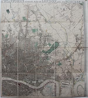
Stanford's library map of London and its suburbs. 24 sheets, on the scale of six inches to a mile. Introductory Notes by Ralph Hyde.
Published by Lympne Castle, Harry Margary in association with Guildhall Library,, 1980
� 172.50
Convert currency� 21.18 shipping from United Kingdom to U.S.A.Quantity: 1 available
Add to basketPublisher's hardback binding with a paper label to the front board. 38.5x46 cms A very good copy. Scarce.
-
Stanford's Library Map of London and it's Suburbs, 24 Sheets, On the Scale of Six Inches to a Mile
Published by Harry Margary, Kent, 1980
Seller: Rooke Books PBFA, Bath, United Kingdom
Association Member: PBFA
Seller rating 5 out of 5 stars

� 75
Convert currency� 14.99 shipping from United Kingdom to U.S.A.Quantity: 1 available
Add to basketLoose Pages, Articles. Condition: Near Fine. None (illustrator). A wonderful new edition of Edward Stanford's renowned map of London, featuring introductory notes by Ralph Hyde. A scarce new edition. Unbound, loose and rolled. A smart facsimile of Edward Stanford's important and detailed map of London and it surrounding suburbs. With an introduction by Ralph Hyde. This map was first published in 1862, and was so popular that it is still in print today. Edward Stanford set our to create to most accurate map of London possible, resulting in this brilliantly detailed map, printed across twenty four sheets on a scale of six inches to a mile. Offering a unique insight into Victorian London, during rapid expansion and change in the city due to the Industrial Revolution. Complete with twenty-four sheets of maps. Unbound, loose and rolled. In very smart condition. Pages very bright and clean. Some scattered handling marks to the title sheet and to the reverse of the final map. Some creasing to the lower corner of the final map. Near Fine. book.
-
Stanford's Library Map of London and Its Suburbs.
Published by Edward Stanford, London, 1862
Seller: George Jeffery Books, HERTFORDSHIRE, United Kingdom
Association Member: PBFA
Seller rating 5 out of 5 stars
� 475
Convert currency� 17.50 shipping from United Kingdom to U.S.A.Quantity: 1 available
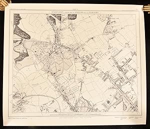
Add to basketCondition: Very Good Plus. Large coloured linen backed map, in 32 secition. This being sheet 6 & 7. Map measures 66x84.cm. Covering the area Holloway Road, North. New Kent Road. South. Bethnal Green. East. Regent Park. West. Map in very good clean condition.
-
Stanford's Library Map of London and Its Suburbs.
Published by Edward Sandford, 1862., 1862
Seller: Michael S. Kemp, Bookseller, Sheerness, KENT, United Kingdom
Association Member: PBFA
Seller rating 5 out of 5 stars
Map First Edition
� 1,400
Convert currency� 20 shipping from United Kingdom to U.S.A.Quantity: 1 available
Add to basket2 parts only of 4. Each sheet 975 x 865 mm. hand coloured mounted on linen in sections. A fine clean example. The first edition of Stanford's attractive large scale map of London, these two maps cover the whole of North London, a further two maps covering the south of the city were published slightly later.