Order Total (1 Item Items):
Shipping Destination:

Southern California Pacific Electric Railway, Used (10 results)
Feedback
Skip to main search results
Search filters
Product Type
- All Product Types
- Books (7)
- Magazines & Periodicals (No further results match this refinement)
- Comics (No further results match this refinement)
- Sheet Music (No further results match this refinement)
- Art, Prints & Posters (No further results match this refinement)
- Photographs (No further results match this refinement)
- Maps (3)
- Manuscripts & Paper Collectibles (No further results match this refinement)
Condition Learn more
Binding
- All Bindings
- Hardcover (No further results match this refinement)
- Softcover (1)
Collectible Attributes
- First Edition (1)
- Signed (2)
- Dust Jacket (No further results match this refinement)
- Seller-Supplied Images (10)
- Not Print on Demand (10)
Language (1)
Free Shipping
- Free Shipping to United Kingdom (No further results match this refinement)
Seller Location
Seller Rating
-
The World Famed Mount Lowe Trip on Lines of the Pacific Electric Ry.[Railway] In Southern California. Sixteen Views in Color
Published by Published by E. C. Kropp Co. no date givenc1923, Milwaukee, 1923
Seller: Keoghs Books, Skipton, United Kingdom
Association Member: PBFA
Seller rating 4 out of 5 stars

First Edition
, 32 unpaginated pages, 16 colour photographs plus photo on the front cover and one page of text inside cover First Edition , spine torn to midway, slight creasing to corners, good condition , full colour printed paper wraps , 19.5 cm x 25 cm Paperback ISBN:
-
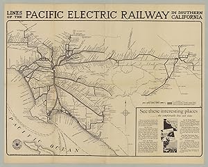
Lines of the Pacific Electric Railway in Southern California
Published by [California]: for Pacific Electric Railway, 1912; corrected to November 1928, 1928
Seller: James Arsenault & Company, ABAA, Arrowsic, ME, U.S.A.
Association Member: ABAA ESA ILAB
Seller rating 5 out of 5 stars

Map
� 655.64
Convert currency� 48.68 shipping from U.S.A. to United KingdomQuantity: 1 available
Add to basketBlack & white map, 17" x 23.25" plus title and margins; inset text and illustrations at lower right. CONDITION: Good, old folds, a few small holes and a bit of toning along folds. A scarce and densely detailed map of the Pacific Electric Railway, initially published a year after Henry E. Huntington lost possession of the company and as it began to rapidly expand, becoming-only a decade later-the world's largest electric railway system. This revised issue of the map reflects the growth of the system to 1928. Boasting of "Comfort-Speed-Safety," the Pacific Electric Railway (fondly called the Red Cars) was a privately-owned mass transit system in Southern California, founded at the turn of the century and operating well into the second half of the 20th century. Twenty-seven years prior to the publication of this map, in November 1901, the eminent book collector and railroad tycoon Henry E. Huntington, along with several investors and the banker I. W. Hellman, would incorporate the Temple Street Cable Railway and the Pasadena and Mt. Lowe Railway into the Pacific Electric Railway Company, which would run until 1961. At its height, the interurban system-consisting of electrically powered streetcars, interurban cars, and buses-covered some 1,100 miles of electrified rail; featured over 2,700 daily trains; and served thousands of daily commuters, travelers, and tourists alike. This map of the Pacific Electric Railway (the PE) was initially made a year after Huntington lost control of his new railroad to the Southern Pacific Transportation Company, which took over the PE in 1911 and would manage it until the end. Under this new ownership the PE grew significantly, incorporating other small railroads in the Los Angeles area. Called the "Great Merger," the PE became the largest electric railway system in the world by the 1920s. The map depicts the PE's lines from San Fernando and the Gabriel Mountains in the north to Newport Beach and Balboa in the south, and from Sanata Monica, Redondo Beach, and San Pedro in the west to Redlands in the east. With trains originating in Los Angeles (indicated by a 'star' at the nexus of multiple rails), the lines extend to all these locations. Virtually every stop is identified along each line and spur. To the South and South-East, the map shows connecting steamship lines, to the north, the south, "Honolulu & Orient," and Catalina Island (via the Wilmington Transportation Co. line). An inset in the lower right corner, promotes visits to Mount Lowe, the beaches, the navel orange district, and various other scenic locales. While the PE did service freight traffic, its primary profits came from passenger service, which waned following World War II. After cutting back its operations the PE shut down its interurban services in 1961 and Southern Pacific picked up what remained of its freight operations. OCLC records just one copy of this 1928 issue. A detailed map of this important Southern California mass transit system. REFERENCES: Burns, Adam. "The Pacific Electric Railway: Comfort, Speed, Safety" at American-Rails online.
-
Freight Rail Lines of the Pacific Electric Railway in Southern California - Southern California's railroads, divided into sales territories.
Publication Date: 1956
Seller: Curtis Wright Maps, Berwyn, IL, U.S.A.
Seller rating 5 out of 5 stars
� 84.85
Convert currency� 18.72 shipping from U.S.A. to United KingdomQuantity: 1 available
Add to basketCondition: Very Good. This map of southern California covers a broad territory between San Fernando and San Bernardino and includes Los Angeles, Santa Monica, and much of Orange County. The railroad lines of the Pacific Electric and the Southern Pacific, plus those jointly operated, are shown according to the legend below the title. Though it formerly comprised one of the largest electrified inter-urban passenger networks in the United States, the Pacific Electric Railway had shifted almost entirely to freight operations by the time of publication. According to a note in the lower right margin, the colors reflect the territories of various district freight agents as of June, 1962; each listed respectively within their territory. Printed in August of 1956. Sheet Width (in) 34.75 Sheet Height (in) 22.25 Condition Description "Formerly folded into 20 segments, with creasing and light wear along former fold lines. Former 'front' panels are toned with age, along with a 3" strip on the left side confined to the margin. Several small holes and tears in the upper left corner, away from the image. Contains contemporary manuscript updates to 1962, according to notes in the lower right margin.".
-
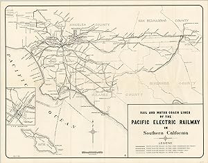
Rail and Motor Coach Lines of the Pacific Electric Railway - Transit map of Southern California showing the routes available to travelers on the Pacific Electric Railway.
Publication Date: 1943
Seller: Curtis Wright Maps, Berwyn, IL, U.S.A.
Seller rating 5 out of 5 stars
� 84.85
Convert currency� 18.72 shipping from U.S.A. to United KingdomQuantity: 1 available
Add to basketCondition: Very Good. Created by a member of the gigantic and influential Southern Pacific Railroad in 1901, the Pacific Electric Railway company operated the largest electric railway system in the world by the early 1920's. Aggressive pursuit by the company's officers led to significant consolidation among private companies and generous land concessions by local politicians for new tracks. This led to a complex network of rail and bus routes owned by a private company connected Orange, Riverside, Los Angeles and San Bernardino counties. This map shows the extent of that interconnected system and includes an inset map of downtown Los Angeles and Union Station. Profits boomed through the 1920's, but by the time this map was published, the service was in a decline. Although traffic increased due to war manufacturing, real estate income from the land grants had largely dried up by the 40's, and the construction of the area's highway system pushed many potential riders to automobile transportation. By 1961, the last assets of the Pacific Electric were sold to the Los Angeles Metropolitan Transit Authority. Sheet Width (in) 21.9 Sheet Height (in) 17 Condition Description The map is intact, but has several condition issues. The front panel is toned and discolored from age, while similar discoloration is also evident along fold lines and in the margins. Several fold intersections are worn and result in minor image loss, but have been repaired on verso to halt further deterioration. Several tape repairs are present within the margins. Despite the issues, the map remains in fair condition, and is an important article from California's transportation history.
-

Rail and Motor Coach Lines of the Pacific Electric Railway - Postwar map showing transit options via the Pacific Electric Railway in Southern California.
Publication Date: 1946
Seller: Curtis Wright Maps, Berwyn, IL, U.S.A.
Seller rating 5 out of 5 stars
� 115.70
Convert currency� 18.72 shipping from U.S.A. to United KingdomQuantity: 1 available
Add to basketCondition: Fine. This map of Southern California vibrantly shows the motor coach and rail lines of the Pacific Electric Railway Company shortly after the end of the Second World War. The combined routes extend from Los Angeles inland to San Bernardino and south to Orange County. Delicate shading shows the region's rugged topography and primary roads are individually labeled. Inset maps show downtown Los Angeles and Santa Catalina Island, accessible via steamship line of the Wilmington Transportation Company. The verso includes an index to primary attractions on the map, a list of stations and timetable, a map of the San Bernardino Mountain Resort Area, and numerous paragraphs lauding the points of interest served by the rail and motor lines. The map was created in 1946 by the California Map Company on behalf of the Pacific Electic Railway Company. Though the transit juggernaut had experienced a boon during the war years, it had been in a period of steady decline in the years leading up to the conflict. The development of the interstate highway system in the 1950's saw the termination of passenger service, and by the mid-1960's the final vestiges of the Pacific Electric had been sold off entirely. Sheet Width (in) 33.4 Sheet Height (in) 21.75 Condition Description Originally issued folded into 24 panels, with minor creasing and wear along fold lines. Near fine condition - a clean sheet with vibrant color.
-
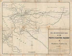
Rail and Motor Coach Lines of the Pacific Electric Railway - Prewar transit map of Southern California showing the network of the Pacific Electric Railway Company.
Publication Date: 1941
Seller: Curtis Wright Maps, Berwyn, IL, U.S.A.
Seller rating 5 out of 5 stars
� 115.70
Convert currency� 18.72 shipping from U.S.A. to United KingdomQuantity: 1 available
Add to basketCondition: Fine. Created by a member of the gigantic and influential Southern Pacific Railroad in 1901, the Pacific Electric Railway company operated the largest electric railway system in the world by the early 1920's. Aggressive pursuit by the company's officers led to significant consolidation among private companies and generous land concessions by local politicians for new tracks. This led to a complex network of rail and bus routes owned by a private company connecting Orange, Riverside, Los Angeles and San Bernardino counties. This map shows the extent of that interconnected system and includes an inset map of downtown Los Angeles and Union Station. Profits boomed through the 1920's, but at the time this map was published in February of 1941, service was in a steep decline. Through the impending Second World War would temporarily boost ridership, real estate income from the land grants had largely dried up by the 40's, and the construction of the area's highway system pushed many potential riders to automobile transportation. By 1961, the last assets of the Pacific Electric were sold to the Los Angeles Metropolitan Transit Authority. Sheet Width (in) 21.75 Sheet Height (in) 17 Condition Description Minor creasing and wear along fold lines, including a few tiny holes at the fold intersections. Otherwise in near fine condition.
-
Lines of Pacific Electric Railway and Motor Transit Company in Southern California - Visualizing the gradual shift from rails to roads for public transportation across Southern California.
Publication Date: 1935
Seller: Curtis Wright Maps, Berwyn, IL, U.S.A.
Seller rating 5 out of 5 stars
� 289.25
Convert currency� 18.72 shipping from U.S.A. to United KingdomQuantity: 1 available
Add to basketCondition: Fine. "Created by a member of the influential Southern Pacific Railroad, Henry Huntington, in 1901, the Pacific Electric Railway Company operated the largest interurban electric railway system in the world by the early 1920s. Aggressive pursuit by the railway's officers led to significant consolidation among private companies and generous land concessions by local politicians for new tracks. This map, drawn by Gerald Eddy and issued in 1935, shows the network after a period of consistent growth throughout the 1920s. Railroads, bus routes, and steamship lines can be seen stretching from Los Angeles inland as far as Big Bear Lake and Idyllwild. Topography is depicted pictorially and several advertisements for the Mt. Lowe Tavern, a popular tourist attraction, can also be seen. By the mid-1930s, the company had expanded into motorcoach transportation, but the electric railways (red) remained the preferred method of transportation for most commuters in the region. This would change after World War II, when more robust road networks and the increasing popularity of the automobile would result in shifting preferences towards buses and private car ownership. Text on the verso describes additional recreational opportunities and leisure trips in the region and presents a list of facts about the Pacific Electric Railway Company. Sources: Southern California Railway Museum, Pacific Electric Railway Maps" Sheet Width (in) 21.3 Sheet Height (in) 15.5 Condition Description Light creasing along originally issued fold lines and a few extraneous creases in the corners. Very good to near fine overall.
-

MT. LOWE WORLD'S GREATEST MOUNTAIN SCENIC TROLLEY TRIP. A Magnificent Panorama of 2,000 Square Miles of Mountains, Valleys, Islands and the Sea. Beautiful Vista of Southern California Presents Itself from the Famous Mountain Summit. Comfortable Accomodations at the Tavern or Housekeeping Cottages May Be Had at Moderate Prices. An Ideal Place for a Vacation. Through Cars at 8-9-10 a.m.; 1:30 and 4:30 p.m. from the Sixth and Main Station, Los Angeles. Pacific Electric Railway
Seller: johnson rare books & archives, ABAA, Covina, CA, U.S.A.
Association Member: ABAA ESA ILAB
Seller rating 5 out of 5 stars
� 3,471.02
Convert currency� 18.72 shipping from U.S.A. to United KingdomQuantity: 1 available
Add to basketAn advertising poster for the Mount Lowe Railway, Southern California's iconic funicular, which closed permanently in 1938. The railway opened on July 4, 1893 and consisted of nearly seven miles of track starting in Altadena, California, to Mount Echo, where a 70-room Victorian hotel, the Echo Mountain House, once stood. The hotel and subsequent replacements were destroyed by natural disasters, and in 1938, a flood washed most everything off the mountainside. This poster features a hand-colored photographic image and is mounted on chipboard. It measures approximately 18" x 39 1/2" and was likely hanging at a railway station. It appears to be circa 1925 as the Tavern's name changed that year from Ye Alpine Tavern to Mount Lowe Tavern. The Tavern burned down in 1936 and was never rebuilt. There is a light tide mark along the lower edge of the panel, with shallow chipping and loss to the corners, not affecting the printed area. This is a rare survivor with no known holdings in special collections or private hands. It was acquired from a longtime collector of Mount Lowe material who prized it in his personal collection for more than 30 years.
-
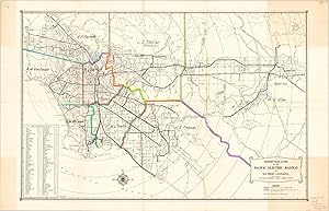
Pacific Electric Railway 1912 Southern California Promotional map rail lines
Publication Date: 1912
Seller: RareMapsandBooks, Dover, NH, U.S.A.
Seller rating 5 out of 5 stars
Map Signed
� 182.81
Convert currency� 52.42 shipping from U.S.A. to United KingdomQuantity: 1 available
Add to basketCondition: good. Lines of the Pacific Electric Railway in Southern California.(North America, United States, California, Southern California, Los Angeles, San Pedro, Pasadena, Pomona, Santa Ana, San Bernardino, Riverside). Issued 1912, Los Angeles by D. W. Pontius for the Pacific Electric Railway. Art signed by M. L. W. Separately issued broadsheet lithographed map with tourist trolley trip advertising at lower right. Scarce early 20th century promotional map detailing electric rail/ trolley car routes in Southern California. Separately issued for public display, inherently scarce/ rare survival. Old fold lines, some wear and browning, short splits on a couple fold lines neatly closed with archival tape on reverse, some small edge nicks in the wide blank margins. Sheet Measures c. 19" H x 24" W. Engraved Area Measures c. 15 1/2" H x 23 1/2" W.[R25555-BR125].
-
Pacific Electric Railway 1912 Southern California Promotional map rail lines
Publication Date: 1912
Seller: RareMapsandBooks, Dover, NH, U.S.A.
Seller rating 5 out of 5 stars
Map Signed
� 289.25
Convert currency� 52.42 shipping from U.S.A. to United KingdomQuantity: 1 available
Add to basketNo Binding. Condition: Good. Lines of the Pacific Electric Railway in Southern California.(North America, United States, California, Southern California, Los Angeles, San Pedro, Pasadena, Pomona, Santa Ana, San Bernardino, Riverside). Issued 1912, Los Angeles by D. W. Pontius for the Pacific Electric Railway. Art signed by M. L. W. Separately issued broadsheet lithographed map with tourist advertising at lower right. Scarce early 20th century promotional map detailing electric rail/ trolley car routes in Southern California. Old fold lines, some wear and browning, short splits on a couple fold lines neatly closed with archival tape on reverse, some small edge nicks. Sheet Measures c. 19" H x 24" W. Engraved Area Measures c. 15 1/2" H x 23 1/2" W.[R25555-BR125]. Signed by Author(s).
![Seller image for The World Famed Mount Lowe Trip on Lines of the Pacific Electric Ry.[Railway] In Southern California. Sixteen Views in Color for sale by Keoghs Books](https://pictures.abebooks.com/inventory/md/md22522498033.jpg)