Order Total (1 Item Items):
Shipping Destination:

South Eastern Portion Australia Compiled by Arrowsmith John (3 results)
Skip to main search results
Search filters
Product Type
- All Product Types
- Books (3)
- Magazines & Periodicals (No further results match this refinement)
- Comics (No further results match this refinement)
- Sheet Music (No further results match this refinement)
- Art, Prints & Posters (No further results match this refinement)
- Photographs (No further results match this refinement)
- Maps (No further results match this refinement)
- Manuscripts & Paper Collectibles (No further results match this refinement)
Condition Learn more
- New (No further results match this refinement)
- As New, Fine or Near Fine (No further results match this refinement)
- Very Good or Good (1)
- Fair or Poor (No further results match this refinement)
- As Described (2)
Binding
- All Bindings
- Hardcover (No further results match this refinement)
- Softcover (No further results match this refinement)
Collectible Attributes
- First Edition (No further results match this refinement)
- Signed (No further results match this refinement)
- Dust Jacket (1)
- Seller-Supplied Images (2)
- Not Print on Demand (3)
Language (1)
Price
- Any Price
- Under � 20 (No further results match this refinement)
- � 20 to � 35 (No further results match this refinement)
- Over � 35
Free Shipping
- Free Shipping to U.S.A. (No further results match this refinement)
Seller Location
Seller Rating
-
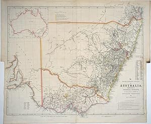
The South Eastern Portion of Australia; Compiled from the Colonial Surveys, and from Details Furnished by Exploratory Expeditions, by John Arrowsmith
Published by John Arrowsmith, 10 Soho Square, London, 1858
Seller: Antipodean Books, Maps & Prints, ABAA, Garrison, NY, U.S.A.
Association Member: ABAA ANZAAB ESA ILAB
Seller rating 3 out of 5 stars

One of John Arrowsmith's superb maps of Australia, this one highlighting the gold districts, and surprisingly, not listed in Tooley or Trove. The map encompasses the coast from Moreton Bay to Spencer Gulf, with an inset map of Australia in the top left corner. The newly proposed New South Wales/Queensland border has been instituted, however the question of the western Queensland border has been avoided by the inset of Australia in the top left corner. (Interestingly, the vignette map of Australia shows the northern border of NSW being an extension of the northern border of South Australia, and "North Australia" is above both of them, not Queensland.) There are 4 lists on the map, "Reference "Gold Fields in New South Wales" ; Counties of New South Wales (68 are listed); "Routes of Travellers into the interior listing 14 expeditions from Oxley in 1817 to Streleski (sic) [Strzelecki] in 1840; Counties in Port Phillip (24 are listed). "London Pubd 2d Jany 1858, by John Arrowsmith, 10 Soho Square". 24 x 20 1/2". Steel engraving with original hand color, central fold. Excellent condition.
-

The South Eastern Portion of Australia; compiled from the Colonial Surveys and from details furnished by Exploratory Expeditions by John Arrowsmith./(inset) Map of Australia showing location of South Australia.
Published by John Arrowsmith, London, 1844
Seller: Arader Galleries of Philadelphia, PA, Philadelphia, PA, U.S.A.
Seller rating 4 out of 5 stars

N/A. Condition: Very Good. Dust Jacket Condition: N/A. Engraving with line hand coloring. Plate No. 35. From The London Atlas of Universal Geography Exhibiting the Physical and Political Divisions of the Various Countries of the World. Sheet size: 21 3/4 x 26 1/2". Inventory#: p715pmat.
-
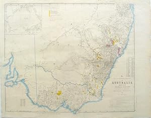
The South Eastern Portion of Australia; Compiled from the Colonial Surveys, and from Details Furnished by Exploratory Expeditions, by John Arrowsmith
Published by John Arrowsmith, London, 1853
Seller: Antipodean Books, Maps & Prints, ABAA, Garrison, NY, U.S.A.
Association Member: ABAA ANZAAB ESA ILAB
Seller rating 3 out of 5 stars
Map of the south eastern Australia with the gold fields of New South Wales and Victoria marked in gold. Arrowsmith was privy to the most recent information from the colonies as the cartographer for the British Crown, and his maps are not only detailed and up-to-date but works of art. There is text in the upper central quadrant "Reference Gold Fields in New South Wales" which includes the names of the fields along with those in the new colony of Victoria. All gold fields are shaded in gold while the holdings of the Australian Agricultural Co. appear in purple, which is quite striking. There is also outline color in blue. 68 counties listed under New South Wales, and 24 listed in Port Phillip (a carry over from the era before Victoria was named.) Printed in the lower right hand corner is a list detailing the "Routes of Travellers into the interior" from 1817 to 1840. "London Pubd 2d Jany 1853, by John Arrowsmith, 10 Soho Square". 24 x 20 1/2". Printed on thin paper with the original folds strengthened. Libraries Australia ID 46007789. Tooley page 250 #84.