
Order Total (1 Item Items):
Shipping Destination:

Road Map Tulare County (5 results)
Skip to main search results
Search filters
Product Type
- All Product Types
- Books (4)
- Magazines & Periodicals (No further results match this refinement)
- Comics (No further results match this refinement)
- Sheet Music (No further results match this refinement)
- Art, Prints & Posters (No further results match this refinement)
- Photographs (No further results match this refinement)
- Maps (1)
- Manuscripts & Paper Collectibles (No further results match this refinement)
Condition Learn more
- New (No further results match this refinement)
- As New, Fine or Near Fine (No further results match this refinement)
- Very Good or Good (2)
- Fair or Poor (No further results match this refinement)
- As Described (3)
Binding
- All Bindings
- Hardcover (No further results match this refinement)
- Softcover (No further results match this refinement)
Collectible Attributes
- First Edition (2)
- Signed (No further results match this refinement)
- Dust Jacket (No further results match this refinement)
- Seller-Supplied Images (4)
- Not Print on Demand (5)
Language (2)
Free Shipping
Seller Location
Seller Rating
-

AAA Road Map Tulare County
Language: English
Published by Automobile Club of Southern California, 1969
No Binding. Condition: Very Good.
-
ROAD MAP OF TULARE COUNTY
Language: English
Published by Automobile Club of Southern California, Los Angeles, CA, 1940
Seller: Robert Gavora, Fine & Rare Books, ABAA, Talent, OR, U.S.A.
Association Member: ABAA CBA ILAB
Seller rating 5 out of 5 stars

Map
Folded map. Condition: Very good plus. Reverse of the map show index for map locations.Sheet measures 17.5 x 23 inches. A very good plus copy.
-
ROAD MAP OF TULARE COUNTY
Published by Automobile Club of Southern California, n.d. [ca 1940), Los Angeles, 1937
Seller: BUCKINGHAM BOOKS, ABAA, ILAB, IOBA, GREENCASTLE, PA, U.S.A.
Association Member: ABAA ILAB IOBA RMABA TXBA
Seller rating 5 out of 5 stars
First Edition
[CALIFORNIA]. First edition. 23" x 17 1/2" sheet, folded to 24 panels. Printed in three colors on both sides. Beginning in 1906, the Auto Club recorded the development of roadways and roadside services in Southern California in a series of strip maps and road maps that remained indispensable to motorists well into the digital age. This mid-century piece opens to a map of Tulare County, which is accompanied by a lengthy index. Published on the eve of World War II, this map precedes the establishment of Rankin Field near Tulare, where more than 10,000 pilots received training, including twelve future Aces and two Medal of Honor Recipients. Mild toning, with a bit of staining to the rear panel; else very good.
-

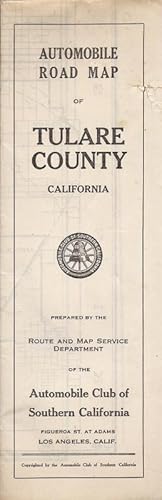
Automobile Road Map of Tulare County, California
Published by Automobile Club of Southern California, Los Angeles, 1919
Seller: Carpe Diem Fine Books, ABAA, Monterey, CA, U.S.A.
Association Member: ABAA ILAB TXBA
Seller rating 5 out of 5 stars
First Edition
First Edition. Large folding map (22" x 28"). Three tears at fold lines, two small spots on front; a very good copy. The left portion of the map lays out the main cities of Dinuba, Oros, Visalia, Exeter, Tulare, Lindsay, Tipton and Porterville. The right portion depics the Sierra Forest Reservation, Sequoia National Park, Tule River Indian Reservation, California Hot Springs, various camps and more.
-
Automobile Road Map of Tulare County, California OVERSIZE
Published by Automobile Club of Southern California c. 1919, Los Angeles, 1919
Seller: Charles Lewis Best Booksellers, San Diego, CA, U.S.A.
Seller rating 5 out of 5 stars
Folding map, [22in by 28in], scale: 3.5in per inch. Features: Sierra Nevada Forest Reserve, Sequoia National Park, General Grant National Park, and the Big Trees. Included also are Tule River Indian Reservation, and the proposed Mount Whitney Road, the highest peak in the Continental United States. Aside from a bit of negligible foxing and a small tear on the left margin, in very good condition.


