Order Total (1 Item Items):
Shipping Destination:

Planisphere Projection Mercator by Bonne Rigobert (6 results)
Feedback
Skip to main search results
Search filters
Product Type
- All Product Types
- Books (4)
- Magazines & Periodicals (No further results match this refinement)
- Comics (No further results match this refinement)
- Sheet Music (No further results match this refinement)
- Art, Prints & Posters (2)
- Photographs (No further results match this refinement)
- Maps (No further results match this refinement)
- Manuscripts & Paper Collectibles (No further results match this refinement)
Condition Learn more
- New (No further results match this refinement)
- As New, Fine or Near Fine (No further results match this refinement)
- Very Good or Good (1)
- Fair or Poor (No further results match this refinement)
- As Described (5)
Binding
- All Bindings
- Hardcover (No further results match this refinement)
- Softcover (No further results match this refinement)
Collectible Attributes
- First Edition (No further results match this refinement)
- Signed (No further results match this refinement)
- Dust Jacket (No further results match this refinement)
- Seller-Supplied Images (5)
- Not Print on Demand (6)
Language (2)
Price
- Any Price
- Under � 20 (No further results match this refinement)
- � 20 to � 35 (No further results match this refinement)
- Over � 35
Free Shipping
- Free Shipping to United Kingdom (No further results match this refinement)
Seller Location
Seller Rating
-

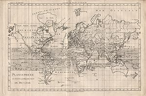
"Planisphere suivant la projection de Mercator." - World map Weltkarte Mappemonde America Australia carte
Published by Paris, 1780
Language: German
Seller: Antiquariat Steffen V�lkel GmbH, Seubersdorf, Germany
Seller rating 5 out of 5 stars

Art / Print / Poster
� 62.98
Convert currency� 24.46 shipping from Germany to United KingdomQuantity: 1 available
Add to basketOriginal Kupferstich-Karte von Rigobert Bonne von ca. 1780. -- Blattmasse: ca. 26 x 39 cm. -- mit Faltspur, sonst gut erhalten. || Original copper engraved map by Rigobert Bonne from c. 1780. -- with fold mark, otherwise in good condition. Wir kaufen und verkaufen alte B�cher, Handschriften, Zeichnungen, Autographen, Grafiken und Fotografien. Wir sind stets am Ankauf von kompletten Bibliotheken, Sammlungen und Nachl�ssen interessiert. Sprache: Deutsch Gewicht in Gramm: 20.
-

"Planisphere suivant la projection de Mercator." - World map Weltkarte Mappemonde America Australia carte
Published by Paris, 1780
Language: German
Seller: Antiquariat Steffen V�lkel GmbH, Seubersdorf, Germany
Seller rating 5 out of 5 stars
Art / Print / Poster
� 62.98
Convert currency� 24.46 shipping from Germany to United KingdomQuantity: 1 available
Add to basketOriginal Kupferstich-Karte von Rigobert Bonne von ca. 1780. -- Blattmasse: ca. 40 x 27 cm. -- gut erhalten. || Original copper engraved map by Rigobert Bonne from c. 1780. -- in good condition. ! Wir kaufen und verkaufen alte B�cher, Handschriften, Zeichnungen, Autographen, Grafiken und Fotografien. Wir sind stets am Ankauf von kompletten Bibliotheken, Sammlungen und Nachl�ssen interessiert. Sprache: Deutsch Gewicht in Gramm: 1550.
-

(World Map) Planisphere Suivant La Projection De Mercator
Published by France, 1780
No Binding. Condition: Very Good. 1st edition thus. Original copper engraving. Date: 1780. Sheet size: 41.5cm x 24.9cm. A map by this important 18th century cartographer which follows Mercator's projection. Uncoloured, as issued. Minor age-marks and fold-lines else in very good, clean condition.
-

Planisphere Suivant la Projection de Mercator
Published by Artist: Bonne Rigobert ( - 1795 ) Paris; issued in: Paris; - Rigobert Bonne (1727?1795) was one of the most important cartographers of the late 18th century In 1773 Bonne succeeded Jacques Nicolas Bellin as Royal Cartographer to France in the office of the Hydrographer at the Dep�t de la Marine Working in his official capacity Bonne compiled some of the most detailed and accurate maps of the period Bonne?s work represents an important step in the evolution of the cartographic ideology away from the decorative work of the 17th and early 18th century towards a more detail oriented and practical aesthetic With regard to the rendering of terrain Bonne maps bear many stylistic similarities to those of his predecessor Bellin However Bonne maps ge, 1727
Seller: Antique Sommer& Sapunaru KG, M�nchen, Germany
Seller rating 5 out of 5 stars
� 350.94
Convert currency� 30.58 shipping from Germany to United KingdomQuantity: 1 available
Add to basketTechnic: Copper print, colorit: coloredcondition: Perfect condition, size (in cm): 21,5 x 32 cm cm; - Map shows the whole world.
-
-

N� 2 - Carte "PLANISPHERE SUIVANT LA PROJECTION DE MERCATOR" pour "L'Atlas de toutes les parties connues du globe terrestre dress� pour l'Histoire philosophique et Politique des Etablissemens et du Commerce des Europ�ens dans les Deux Indes" par Guillaume Thomas Francois Raynal - 1780 -
� 143.97
Convert currency� 15.73 shipping from France to United KingdomQuantity: 1 available
Add to basketune carte ancienne grav�e sur cuivre (Copper etching) en noir par Andr�, grav�e par Arrivet. Format : 31 x 20,5 cm, pour illustrer l'uvre de l'Abb� Guillaume-Thomas Raynal intitul�e "l'Histoire philosophique et Politique des Etablissemens et du Commerce des Europ�ens dans les Deux Indes", pli central horizontal normal venant d'un atlas( horizontal centerfold), 1780 Gen�ve Pellet Editeur, superbe carte.en tr�s bon �tat ( very good condition).