
Order Total (1 Item Items):
Shipping Destination:

Plan Town Goderich Upper Canada by Bouchette (2 results)
Skip to main search results
Search filters
Product Type
- All Product Types
- Books (1)
- Magazines & Periodicals (No further results match this refinement)
- Comics (No further results match this refinement)
- Sheet Music (No further results match this refinement)
- Art, Prints & Posters (No further results match this refinement)
- Photographs (No further results match this refinement)
- Maps (1)
- Manuscripts & Paper Collectibles (No further results match this refinement)
Condition Learn more
- New (No further results match this refinement)
- As New, Fine or Near Fine (1)
- Very Good or Good (No further results match this refinement)
- Fair or Poor (No further results match this refinement)
- As Described (1)
Binding
- All Bindings
- Hardcover (No further results match this refinement)
- Softcover (No further results match this refinement)
Collectible Attributes
- First Edition (No further results match this refinement)
- Signed (No further results match this refinement)
- Dust Jacket (No further results match this refinement)
- Seller-Supplied Images (2)
- Not Print on Demand (2)
Language (1)
Price
- Any Price
- Under � 20 (No further results match this refinement)
- � 20 to � 40 (No further results match this refinement)
- Over � 40
Free Shipping
- Free Shipping to U.S.A. (No further results match this refinement)
Seller Location
Seller Rating
-

Plan of the Town of Goderich Upper Canada
Published by J & C Walker, London, 1829
Seller: Alexandre Antique Prints, Maps & Books, Toronto, ON, Canada
Seller rating 4 out of 5 stars

Map
Condition: Excellent. The first printed map of Goderich, Size : 190x200 (mm), 7.5x7.875 (Inches), Hand Colored.
-
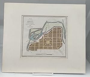
Plan of the Town of Goderich, Upper Canada, Founded by the Canada Company, 1829
Published by [Longman, Rees, Orme, Brown, and Green] [1831], London, 1831
Seller: Attic Books (ABAC, ILAB), London, ON, Canada
Seller rating 5 out of 5 stars

Condition: Near fine. 22 x 28 cm page with 19 x 20 cm coloured steel engraving map. Taped to 32 x 38 cm cardboard frame. Source is "The British Dominions in North America; or a Topographical and Statistical Description of the Provinces of Lower and Upper Canada, New Brunswick, Nova Scotia, the Island of Newfoundland, Prince Edward, and Cape Breton," published 1831. J & C Walker - John Walker, Alexander Walker and Charles Walker, known collectively as J & C Walker (active 1820-95) - were engravers, draughtsmen and publishers working through the 19th century. The firm engraved a large corpus of work for the British Admiralty and produced numerous high-quality geographical maps and nautical charts for a variety of other institutions. This map of Goderich, Huron County shows early street names, Maitland River, marketplace, etc.