Plan Rade Batavia Nautical Chart (1 results)
Title:
Published by Publisher unknown c1760- 1780 1760
- Map
Seller: Keoghs Books, Skipton, United KingdomKeoghs Books
Contact seller5-star sellerCondition: Used
£ 50.00
£ 28.00 shippingShips from United Kingdom to U.S.A.Quantity: 1 available
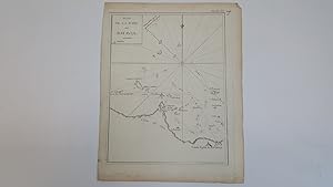
, single unfolded page 28.5 x 22 cms bearing black and white engraved map ( 24 x 18.5 cms ), printed plate XX to top corner with inked 107, this same map is found as plate 107 in Atlas Universelle aus dem Jahre 1787 by Philippe de Pretot but this is a larger version from an unknown publication. There are also copies of this map…in Le Petit Atlas maritime recueil de cartes et plans des quatre parties du Monde. Paris: Bellin, 1764, but again they are smaller. , edges to page a little uneven, map in near fine condition 28.5 x 22 cms Map ISBN.
