
Order Total (1 Item Items):
Shipping Destination:

Plan Boston by Mitchell Augustus (20 results)
Skip to main search results
Search filters
Product Type
- All Product Types
- Books (18)
- Magazines & Periodicals (No further results match this refinement)
- Comics (No further results match this refinement)
- Sheet Music (No further results match this refinement)
- Art, Prints & Posters (No further results match this refinement)
- Photographs (No further results match this refinement)
- Maps (2)
- Manuscripts & Paper Collectibles (No further results match this refinement)
Condition Learn more
- New (No further results match this refinement)
- As New, Fine or Near Fine (2)
- Very Good or Good (2)
- Fair or Poor (No further results match this refinement)
- As Described (16)
Binding
- All Bindings
- Hardcover (No further results match this refinement)
- Softcover (No further results match this refinement)
Collectible Attributes
- First Edition (No further results match this refinement)
- Signed (No further results match this refinement)
- Dust Jacket (No further results match this refinement)
- Seller-Supplied Images (18)
- Not Print on Demand (20)
Language (1)
Free Shipping
Seller Location
Seller Rating
-
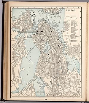
1894 Original Handcolor Map: PLAN OF BOSTON, MASSACHUSETTS
Published by Chicago : John E. Potter & Company, 1894
Map
Map. Condition: Very Good. Original hand-colored leaf from John E. Potter and Company's, "The New Family Atlas." Please refer to photo for condition. PLEASE NOTE: If two images are shown they represent the obverse and reverse of the same leaf--not two separate leaves. Overall dimensions approx. 26" x 15.25". This item will be shipped flat.
-

Plan of Boston
Published by Bradley, Philadelphia, 1882
Seller: Nicholas D. Riccio Rare Books, ABAA, Florham Park, NJ, U.S.A.
Seller rating 4 out of 5 stars

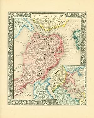
Unbound, colored engraved map, decorative border, 23"x 15". Some toning and aging, small tape repair in margin; otherwise very good. Maps are wrapped with acid free board, or in rigid sleeves. The Mitchell family started to produce atlases in 1846, and continued into the early 1890s. Around 1860, S. Augustus Mitchell Jr. took over, and the atlas would be called Mitchell's New General Atlas. This is a detailed double page map of Boston from the 1882 installment of this atlas. The map includes a small inset illustrating Boston Harbor & Islands. Ristow 311-313 Phillips 907.
-
Plan of Boston.
Published by Philadelphia:, 1865
Seller: Nicholas D. Riccio Rare Books, ABAA, Florham Park, NJ, U.S.A.
Seller rating 4 out of 5 stars
Unbound, colored engraved map, decorative border, 14"x 11". Slight toning and aging, a little margin staining, a few small nicks in margins, wide margins; overall bright and clean. Maps are wrapped with acid free board, or in rigid sleeves. The Mitchell family started to produce atlases in 1846, and continued into the early 1890s. Around 1860, S. Augustus Mitchell Jr. took over, and the atlas would be called Mitchell's New General Atlas. This is a nice colorful map of Boston, including an inset of Boston Harbor, from the 1865 installment of this atlas. Ristow 311-313.
-
20 1/2 x 13 inches. Condition: Very good. 1879 edition. This ia a double page map with an inset map of the immediate region. This lithograph was colored at the time of publication. Of importance is the display of the railroad network in place at the time of the printing of this map. The inset map along with the overall map shows the coverage of the area with railroads, a most important theme for the period.
-
Map. Map, 11 x 9.25 inches, on sheet 15.5 x 13 inches. Printed in black on tan paper, hand-colored in red, yellow and blue. Map includes the wards and surrounding towns and neighborhoods distinguished by color. Inset map of Boston harbor. Map surrounded by floral border. Map is near fine. Sheet has some tanning to edges.
-

Plan of Boston - City plan of Boston published shortly before the outbreak of Civil War.
Publication Date: 1860
Seller: Curtis Wright Maps, Berwyn, IL, U.S.A.
Seller rating 4 out of 5 stars
Condition: Fine. This marvelous plan of Boston, Massachusetts was published in Philadelphia in 1860 by Samuel Augustus Mitchell. Mitchell was one of the most prominent American mapmakers of the 19th century, and initially got involved with cartography as a school teacher who was frustrated with the quality of available maps. He collaborated with skilled engravers and produced high-quality maps and atlases that contained the most up to date information available. Mitchell's son (of the same name) would take over the business after his death in 1860 and continue the tremendous output. His attention to detail is evident within the image, which provides an engaging overview of the abolitionist hotspot on the eve of the Civil War. Bright hand color defines the 'original' city limits from those of surrounding communities like South Boston, Charlestown, and East Cambridge. Numerous railroads are depicted and named, with several managing the impressive engineering feat of crossing the Charles River or Boston Harbor. Ferry routes are also noted. A fascinating variety of buildings are outlined and labeled, several of which (Custom House, Quincy Market, Revere House, and State House) can still be visited today. Sheet Width (in) 12.2 Sheet Height (in) 15.25 Condition Description Scattered staining visible in the margins, most evident in the upper right. A few spots visible in the image (upper corners), but overall in very good condition. A crisp impression with vibrant hand color.
-

Plan of Boston - Boston during the Gilded Age.
Publication Date: 1880
Seller: Curtis Wright Maps, Berwyn, IL, U.S.A.
Seller rating 4 out of 5 stars
Condition: Fine. This beautiful hand-colored map of Boston was published in 1880 as part of Samuel Augustus Mitchell's New General Atlas. A robust network of railroads, ferries, and roads is boldly shown throughout the image. Various locations of interest are labeled, including Quincy Market, the post office, the Atheneum, customs house, and numerous hotels and theaters. An inset in the lower right presents a simple map of the surrounding area and Boston Harbor. Samuel Augustus Mitchell was one of the most prominent American mapmakers of the 19th century and initially got involved with cartography as a school teacher who was frustrated with the quality of available maps. He collaborated with skilled engravers and produced high-quality maps and atlases that contained the most up-to-date information available. This attention to detail, combined with his tremendous publication output, made him and his successors one of the most influential cartographic firms of the era. Sheet Width (in) 23.2 Sheet Height (in) 15.25 Condition Description Double-page map with creasing down the vertical centerfold, as issued. Light wear visible in the margins, including a few small tears. Very good to near fine condition overall.
-

Plan of Boston
Publication Date: 1887
Seller: Art Source International Inc., Boulder, CO, U.S.A.
Seller rating 5 out of 5 stars

This map was made by S. Augustus Mitchell for "Mitchells New General Atlas" published in 1887. The well maintained maps in this atlas feature Mitchell's characteristic pastel coloring and abundant details of geographical features. The plan of Boston is illustrated on this map. Details include the names of streets, important buildings, rivers, lakes, parks, bridges and railroads. Sections of the city are distinguished by color. These 1887 maps offer a fascinating perspective of areas that have since undergone significant growth and change, in addition to their value as great examples of Mitchell's work. This map measure 20.75 inches by 13.75 inches.
-

Plan of Boston
Publication Date: 1888
Seller: Art Source International Inc., Boulder, CO, U.S.A.
Seller rating 5 out of 5 stars
This map of Boston was made by S. Augustus Mitchell for "Mitchells New General Atlas" published in 1888, by WM. M. Bradley & Co. The well maintained maps in this atlas feature Mitchell's characteristic pastel coloring and abundant details of geographical features. Details include the names of streets, railroads, transportation routes, and various points of interest. These 1888 maps offer a fascinating perspective of areas that have since undergone significant growth and change, in addition to their value as great examples of Mitchell's work. This map measure 21 inches by 13.5 inches.
-

Plan of Boston
Publication Date: 1884
Seller: Art Source International Inc., Boulder, CO, U.S.A.
Seller rating 5 out of 5 stars
This map was made by S. Augustus Mitchell for "Mitchells New General Atlas" published in 1884, by WM. M. Bradley & Co. The well maintained maps in this atlas feature Mitchell's characteristic pastel coloring and abundant geographical features. Details include the names of streets, rail roads, depots, canals, parks, rivers and creeks. City sections are distinguished by color. These 1884 maps offer a fascinating perspective of areas that have since undergone significant growth and change, in addition to their value as great examples of Mitchell's work. This map measure 20.5 inches by 13.5 inches.
-

Plan of Boston
Publication Date: 1867
Seller: Art Source International Inc., Boulder, CO, U.S.A.
Seller rating 5 out of 5 stars
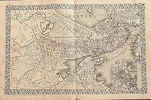
The Mitchell company was one of the first to try out the new technique of engraving on steel plates, experimenting with steel almost 20 years before the rest of the publishing industry. He was printing with steel in the early 1830s; the general switch to steel was approximately 1850. During the early years of the company, Mitchell published mainly maps and travel guides. In 1860, Mitchell started producing "Mitchell's New General Atlas", and Mitchell Sr. retired and turned the business over to his son of the same name. The New General Atlas was published until 1893. Today Mitchell maps are sought after for their fine engraving, bright coloring, and attention to detail. They are some of the finest maps produced in the 1860's. This map produced in 1867, has Mitchell's unique floral border, and beautiful hand coloring. This map details the city of Boston, streets,railroads, ferry routes and city sections are shown.An inset map of the country around Boston showing also its harbor and islands. This map measure 9.5 inches by 11 inches.
-

Plan of Boston
Publication Date: 1868
Seller: Art Source International Inc., Boulder, CO, U.S.A.
Seller rating 5 out of 5 stars
This hand colored map was made for "Mitchells New General Atlas" published in 1868 by S. Augustus Mitchell, Jr. The plan of the city of Boston is illustrated on this map. An inset shows the vicinity of Boston at a greater scale than the main map. Sections of the city are distinguished by color. Other details include the names of streets and important buildings, railroads, major roads,and rivers. The pastel coloring in this atlas is very beautiful and more muted than typical. This map measure 9.5 inches by 11 inches.
-

Plan of Boston including Charlestown, East Cambridge, East Boston, South Boston with inset map of Boston Harbor
Publication Date: 1866
Seller: Art Source International Inc., Boulder, CO, U.S.A.
Seller rating 5 out of 5 stars
The Mitchell company was one of the first to try out the new technique of engraving on steel plates experimenting with steel almost 20 years before the rest of the publishing industry. He was printing with steel in the early 1830s; the general switch to steel was approximately 1850. During the early years of the company, Mitchell published mainly maps and travel guides. In 1860, Mitchell started producing "Mitchell's New General Atlas",and Mitchell Sr. retired and turned the business over to his sonof the same name. The New General Atlas was published until1893. Today Mitchell maps are sought after for their fine engraving, bright coloring, and attention to detail. They aresome of the finest maps produced during this time period. This map produced in 1866, has Mitchell's unique floral border, and beautiful hand coloring. This map details Boston including Charlestown, East Cambridge, East Boston, South Boston with an inset map of Boston Harbor. Counties, cities, towns, lakes, rivers, mountains, and transportation routes are noted. Each map was printed on thick paper with vibrant hand color. This map measure 9.25 inches by 11 inches.
-

Plan of Boston, with Inset of Surrounding Areas
Publication Date: 1875
Seller: Art Source International Inc., Boulder, CO, U.S.A.
Seller rating 5 out of 5 stars
This map was produced by S. Augustus Mitchell in 1875 for his New General Atlas. This map shows Mitchells traditional grape vine border, characteristic pastel coloring and abundant details of geographical features. Counties are distinguished by different colors. Wagon trails and major routes of transport are also shown. These 1875 maps offer a fascinating perspective of areas that have since undergone significant growth and change, in addition to their value as great examples of Mitchell's work. This map measure 20.5 inches by 13 inches.
-

Plan of Boston including Charlestown, East Cambridge, East Boston, South Boston with inset map of Boston Harbor
Publication Date: 1863
Seller: Art Source International Inc., Boulder, CO, U.S.A.
Seller rating 5 out of 5 stars
The Mitchell company was one of the first to try out the new technique of engraving on steel plates, experimenting with steel almost 20 years before the rest of the publishing industry. He was printing with steel in the early 1830s; the general switch to steel engraving was approximately 1850. During the early years of the company, Mitchell published mainly maps and travel guides. In 1860, Mitchell started producing "Mitchell's New General Atlas". Mitchell Sr. retired and turned the business over to his son of the same name. The New General Atlas was published until 1893. Today Mitchell maps are sought after for their fine engraving, bright coloring, and attention to detail. They are some of the finest maps produced in the 1860's. This map, produced in 1863, shows Mitchell's famous flower border, which is only seen in the early editions of his atlases. This map shows Boston as well as an inset of Boston Harbor. This map measure 11 inches by 14 inches.
-

Mitchell's 1865 Map of the Plan of Boston
Publication Date: 1865
Seller: Art Source International Inc., Boulder, CO, U.S.A.
Seller rating 5 out of 5 stars
In 1860 S. Augustus Mitchell Jr. took over his father's map publishing business and in that year he started publishing Mitchell's New General Atlas. Editions of the new general were issued annually until 1887. Mitchell Jr. continued publishing this atlas until 1879. The editions from 1880 to 1887 were published by Wm. M. Bradley. This map published in 1865 is a wonderful example of Mitchell's map-making prowess with beautiful original hand-coloring. This map measure 10.5 inches by 11.25 inches.
-

Plan Of Boston
Publication Date: 1877
Seller: Art Source International Inc., Boulder, CO, U.S.A.
Seller rating 5 out of 5 stars
This hand colored map was made for "Mitchells New General Atlas" published in 1877 by S. Augustus Mitchell. Boston is illustrated on this map. Sections of the city are highlighted by color. Other details include the names of streets, important monuments, railroads, and rivers. This map measure 20.5 inches by 13.5 inches.
-

Plan of Boston
Publication Date: 1872
Seller: Art Source International Inc., Boulder, CO, U.S.A.
Seller rating 5 out of 5 stars
S. Augustus Mitchell Jr., made this hard to find map of Boston and the surrounding area in 1872. Surrounding the beautifully hand colored map is the characteristic traditional ivy style border. Details on the map included street names, parks, reservoirs, ferry lines, and identification of important landmarks. An inset map shows the country around Boston showing also its harbor and islands. This map measure 21 inches by 13 inches.
-

Plan of Boston
Publication Date: 1861
Seller: Art Source International Inc., Boulder, CO, U.S.A.
Seller rating 5 out of 5 stars
This exceptional map is from "Mitchells New General Atlas" published by S. Augustus Mitchell, Jr in 1861. This steel plate engraved map has original hand coloring and crisp engraved lines. Maps from this 1861 ( 2nd edition) atlas have become very difficult to acquire.Surrounding this map of the plan of Boston,is a ' inch floral border. Counties provinces, many cities,rivers and lakes are identified on this beautiful map.An inset map of the country around Boston showing also its harbor islands is included. This map measure 9.25 inches by 11 inches.
-

Plan of Boston
Publication Date: 1878
Seller: Art Source International Inc., Boulder, CO, U.S.A.
Seller rating 5 out of 5 stars
This map was produced by Augustus Mitchell in 1878 for his New General Atlas. Highlights of this map are Mitchells traditional grapevine border, characteristic pastel coloring and abundant details of geographical features. The city plan of Boston is illustrated on this map with an inset of Boston Harbor. Wards and surrounding towns and neighborhoods are distinguished by color. This 1878 map offers a fascinating perspective of areas that have since undergone significant growth and change, in addition to the value as great examples of Mitchell's classic mapmaking style. This map measure 21 inches by 13.5 inches.
