Original Map Egypt by Smith Benjamin (1 results)
Published by Charles Smith, London, England 1808
- First Edition
- Map
Seller: Barry Cassidy Rare Books, Sacramento, CA, U.S.A.Barry Cassidy Rare Books
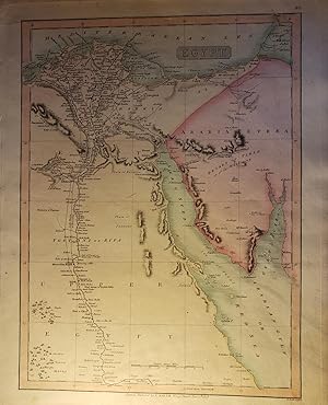
Contact seller5-star sellerNo Binding. Condition: Collectible-Fine. 1st Edition. Original hand-colored, copperplate engraved map showing upper Egypt, the Nile River and Delta, and "Arabia Petraea." Measures 12 1/2" x 15 1/2" with margins. Actual map area is 10 1/2" x 14 1/8." This is a beautiful map with pink, blue, orange, and green watercoloring. Major…cities are shown along the Nile River and Delta and in Arabia. In addition to the Nile, other natural features are shown such as mountains, deserts, oases, the Red Sea, and the Mediterranean Sea. Map is very clean and intact overall with minimal age wear. A fine copy. Title printed at the top within map border. Scales of distance are at the bottom within the map border. Lines and axes of latitude and longitude included. "No. 40" printed in the upper-right corner. Printed at the bottom below the map area is the following information: "London. Published by C. Smith. No. 172 Strand, Jany. 6th, 1808. B. Smith sculpsit." Charles Smith (1768-1852) was an acclaimed British publisher of maps, atlases, and charts. Benjamin Smith (1754-1833) was a British engraver and publisher who became one of the most renowned in the London engraving industry. This map was printed for the first 1808 edition of Smith's New General Atlas Containing Distinct Maps of All the Principal Empires, Kingdoms, and States Throughout the World, Carefully Delineated from All the Best Authorities Extant.
