
Order Total (1 Item Items):
Shipping Destination:

Old Series Ordnance Survey by Harley, First Edition (21 results)
Feedback
Skip to main search results
Search filters
Product Type
- All Product Types
- Books (8)
- Magazines & Periodicals (No further results match this refinement)
- Comics (No further results match this refinement)
- Sheet Music (No further results match this refinement)
- Art, Prints & Posters (No further results match this refinement)
- Photographs (No further results match this refinement)
- Maps (13)
- Manuscripts & Paper Collectibles (No further results match this refinement)
Condition
- All Conditions
- New (No further results match this refinement)
- Used (21)
Binding
- All Bindings
- Hardcover (20)
- Softcover (No further results match this refinement)
Collectible Attributes
- First Edition (21)
- Signed (No further results match this refinement)
- Dust Jacket (21)
- Seller-Supplied Images (6)
- Not Print on Demand (21)
Language (2)
Free Shipping
Seller Location
Seller Rating
-

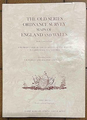
The old series ordnance survey maps of England and Wales; volume III (3, three) (South-central England).
Published by Lympne Castle: Harry Margary, 1981., 1981
Seller: Cornell Books Limited, Tewkesbury, United Kingdom
Association Member: PBFA
Seller rating 5 out of 5 stars

Map First Edition
Condition: Good. First edition of volume 3 (hardback). 4to (34cm by 25cm), liv, 80pp. Colour frontispiece, text illustrations. Original blue cloth, dustwrapper. The book is in very good condition; the dustwrapper is in good to very good condition (closed tear to the front panel). High-quality reproductions of sheets 8 - 12 and 14 - 19 of the old series of the ordnance survey, covering Surrey, Hampshire, Dorset and parts of Wiltshire, Somerset and Sussex. The editors used the earliest copies of the maps they could get their hands on; in this volume the maps were published between 1810 and 1817. ISBN 0903541033.
-
The old series ordnance survey maps of England and Wales; volume III (3, three) (South-central England).
Published by Lympne Castle: Harry Margary, 1981., 1981
Seller: Cornell Books Limited, Tewkesbury, United Kingdom
Association Member: PBFA
Seller rating 5 out of 5 stars
Map First Edition
Condition: Near Fine. First edition (hardback). 4to (34cm by 25cm), liv, 80pp. Colour frontispiece, text illustrations. Original blue cloth, dustwrapper. Light spotting to the top edge of the text block, else the book and the dustwrapper are in very good condition. High-quality reproductions of sheets 8 - 12 and 14 - 19 of the old series of the ordnance survey, covering Surrey, Hampshire, Dorset and parts of Wiltshire, Somerset and Sussex. The editors used the earliest copies of the maps they could get their hands on; in this volume the maps were published between 1810 and 1817. ISBN 0903541033.
-
The old series Ordnance Survey maps of England and Wales, volume III (3), South Central England.
Published by Harry Margary 1981, 1981
Seller: Holybourne Rare Books ABA ILAB, Alton, United Kingdom
Association Member: ABA ILAB PBFA
Seller rating 5 out of 5 stars
First Edition
ISBN10: 0903541033ISBN13: 9780903541039 First edition Hardback. Near Fine, edges dusty slight bumping, in clean and bright dustwrapper. Showing very minor wear, slight spotting, small taears, slight discolouration, Some bumping, which is housed in a protective removable sleeve. There are no ink marks or writing. Excellent clean example. JHRB 13185.
-

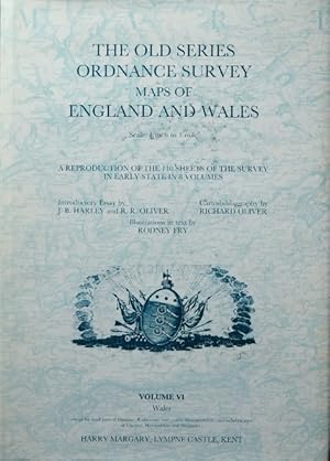
The Old Series Ordnance Survey Maps pf England and Wales. Volume 6. Wales
Published by Harry Margary, United Kingdom, 1992
ISBN 10: 0903541440 ISBN 13: 9780903541442
Language: English
Seller: Carmarthenshire Rare Books, Carmarthen, United Kingdom
Seller rating 5 out of 5 stars
First Edition
Hardcover. Condition: Fine. Dust Jacket Condition: Fine. 1st Edition. original cloth hardcover, illustrated throughout, 164 pages, a fine clean copy in fine unclipped dustwrapper. We are a real bookshop with real books situated in and shipping from the United Kingdom. Shelf B219.
-

The Old Series Ordnance Survey Maps of England and Wales : Volume IV Central England
Seller: Martin Bott Bookdealers Ltd, Felixstowe, United Kingdom
Seller rating 5 out of 5 stars
First Edition
Hardcover. Condition: VG. Dust Jacket Condition: VG-. 1st. Volume 6 of these reprints of the first series Ordance Survey 1" maps with extensive notes - this one covers the West & Sourthern Midlands. lxiv+96pp. VG clean copy in slightly worn dust wrapper. Uncommon.
More buying choices from other sellers on AbeBooks
Used offers from � 58.60
Also find Hardcover First Edition
-
The Old Series Ordnance Survey Maps of England and Wales : Volume VI Wales
Seller: Martin Bott Bookdealers Ltd, Felixstowe, United Kingdom
Seller rating 5 out of 5 stars
First Edition
Hardcover. Condition: VG. Dust Jacket Condition: VG. 1st. Volume 6 of these reprints of the first series Ordance Survey 1" maps with extensive notes - this one covers all of Wales. lviii+107pp. VG clean copy in dust wrapper. Scarce. Heavy - UK postage �6.95.
More buying choices from other sellers on AbeBooks
Used offers from � 58.60
Also find Hardcover First Edition
-
THE OLD SERIES ORDNANCE SURVEY MAPS OF ENGLAND AND WALES. Scale: 1 Inch to 1 mile. A Reproduction of the 110 Sheets of the Survey in Early State in 8 Volumes. Introductory Essay by . Carto-bibliography by Richard Oliver. Illustrations in text by Rodney Fry. Volume VI [Only]: WALES (except for small parts of Flintshire, Radnorshire and eastern Monmouthshire, and including parts of Cheshire, Herefordshire and Shropshire).
Published by Harry Margary Lympne Castle Kent, 1992
Seller: Francis Edwards ABA ILAB, Hay on Wye, United Kingdom
Association Member: ABA ILAB PBFA
Seller rating 5 out of 5 stars
First Edition
1st Ed. 4to. lviiipp. 107 sheets of maps, several figures. Good in d/w. Additional postage may be necessary US$37.
-

The Old Series Ordnance Survey Maps of England and Wales. Volume VII. North-central England
Published by Harry Margary, London, 1989
ISBN 10: 0903541076 ISBN 13: 9780903541077
Language: English
Seller: Barter Books Ltd, Alnwick, NORTH, United Kingdom
Association Member: IOBA
Seller rating 5 out of 5 stars
Map First Edition
Blue/gilt hardback cloth cover. Condition: Very Good. First Edition. VG : in very good condition with dust jacket. Minor chip at jacket spine head. Neat inscription on fep. 350mm x 250mm (14" x 10"). lxx, 103pp. 126 b/w plates + 8 b/w extracts. Heavy item - shipping supplement may apply for overseas.
-
The old series Ordnance Survey maps of England and Wales; volume VI (6), Wales.
Published by Lympne Castle: Harry Margary, 1992., 1992
Seller: Cornell Books Limited, Tewkesbury, United Kingdom
Association Member: PBFA
Seller rating 5 out of 5 stars
Map First Edition
Condition: Near Fine. First edition (hardback), volume 6, covering Wales. 4to, lviii, 107pp. Text illustrations. Original blue cloth, dustwrapper. the book and the dustwrapper are in very good condition. Volume 6 in Harry Margary's complete reproduction of early printings of the 110 sheets of the old series; this volume was the last to be published, and covers sheets 28, 36-42, 56-60, 74-79 (originally published between 1818 and 1841). These sheets cover the whole of Wales (with the exception of the detached part of Flintshire and a small part of Denbighshire). The series was originally plotted in 10 volumes, but a decision was taken half-way through publication to reduce the number to 8 by combining the two Welsh volumes (into this volume) and the two Northern volumes (into what became volume 8). ISBN 0903541440.
-
The old series Ordnance Survey maps of England and Wales, volume V (5), Lincolnshire, Rutland and East Anglia.
Published by Lympne Castle: Harry Margary, 1987., 1987
Seller: Cornell Books Limited, Tewkesbury, United Kingdom
Association Member: PBFA
Seller rating 5 out of 5 stars
Map First Edition
Condition: Near Fine. First edition (hardback), volume 5, covering Lincolnshire, Rutland and East Anglia. 4to (35cm by 26cm), lvi, 90 pages of maps. Original blue cloth, dustwrapper. The book and the dustwrapper are in very good condition. High-quality reproductions of sheets 49-51, 64-70 and 83-86 of the old series of the ordnance survey, covering the eastern counties. The editors used the earliest copies of the maps they could get their hands on; in this volume the maps were published between 1824 and 1838. ISBN 090354105X.
-
The old series Ordnance Survey maps of England and Wales, volume V (5), Lincolnshire, Rutland and East Anglia.
Published by Lympne Castle: Harry Margary, 1987., 1987
Seller: Cornell Books Limited, Tewkesbury, United Kingdom
Association Member: PBFA
Seller rating 5 out of 5 stars
Map First Edition
Condition: Near Fine. First edition (hardback), volume 5, covering Lincolnshire, Rutland and East Anglia. 4to (35cm by 26cm), lvi, 90 pages of maps. Original blue cloth, dustwrapper. Short ownership inscription, else the book and the dustwrapper are in very good condition. High-quality reproductions of sheets 49-51, 64-70 and 83-86 of the old series of the ordnance survey, covering the eastern counties. The editors used the earliest copies of the maps they could get their hands on; in this volume the maps were published between 1824 and 1838. ISBN 090354105X.
-

Old Series Ordnance Survey Maps of England and Wales, Vol. 8. (Northern England and the Isle of Man.)
Published by Harry Margary., Lympne Castle, Kent, UK., 1991
ISBN 10: 0903541459 ISBN 13: 9780903541459
Language: English
Seller: Cocksparrow Books, Salisbury, WILTS, United Kingdom
Seller rating 4 out of 5 stars

First Edition
Hardcover. Condition: F/F/VG++. Dust Jacket Condition: Very Good. 1st Edition. HARDBACK "RARE VOL VII IN THE SERIES," SHIPPED FROM THE UK* Edition: 1st.* Impression: 1st * Date of Publication: 1991. * Publisher: Harry Margary, Lympne Castle, Kent. * Binding and cover condition: Dark blue cloth covered boards, gilt title to spine only. No visible marks or wear. FINE.* Jacket condition: Colour illustrated dust wrapper showing the armorial bearing of the Ordnance Survey with red titles to spine and face. No visible shelf wear to top or bottom edges, head or tail of spine, some spotting to front & rear of jacket. Now in a clear un-attached protective wrapper. VG++.* Contents condition: PRIVATE COPY NOT EX-LIBRARY. Clean, crisp, tight and bright with no reading wear, no marks to text, no visible marks to page edges, no visible faults. FINE.* Illustrations: Some b/w line drawn illustrations & b/w full page plates to introduction. Numerous single sided map section reproductions throughout. * Pages: 252 pp. text. lxxiv pp. introduction and appendices at front & blank pages at rear.* Description: Volume 8 is the rarest volume in the series; it has been rumoured that much of the stock was destroyed in a warehouse fire, and it certainly went out of print extremely quickly. A reproduction of the 110 sheets of the survey in early state in ten volumes of which this is volume VIII containing those for Northern England and The Isle Of Man, (Cumberland, Durham, Isle of Man, Northumberland, Westmorland and Yorkshire, North Riding and Parts of Lancashire and Yorkshire, East and West Ridings.). Scale one inch to the mile.* A FINE text copy of the 1st./1st. with some slight marks to jacket now in a clear un-attached protective dust jacket.*.
-
The old series Ordnance Survey maps of England and Wales, volume VIII (8), Northern England and the Isle of Man.
Published by Lympne Castle: Harry Margary, 1991., 1991
Seller: Cornell Books Limited, Tewkesbury, United Kingdom
Association Member: PBFA
Seller rating 5 out of 5 stars
Map First Edition
Condition: Good. First edition (hardback), volume 8 (Northern England). 4to (34cm by 25cm), lxxii, 125 pages of maps. Original blue cloth, but lacks the dustwrapper. This book was formerly in a reference library, with a couple of discreet stamps, but the book is nonetheless in good to very good condition overall. High-quality reproductions of sheets 91-110 of the old series of the ordnance survey, covering England north of the Preston-Hull line, plus the Isle of Man. The editors used the earliest copies of the maps they could get their hands on; in this volume the maps were published between 1847 and 1874. Volume 8 is the rarest volume in the series; it has been rumoured that much of the stock was destroyed in a warehouse fire, and it certainly went out of print extremely quickly. ISBN 0903541459.
-
The old series Ordnance Survey maps of England and Wales, volume IV (4), Central England.
Published by Lympne Castle: Harry Margary, 1986., 1986
Seller: Cornell Books Limited, Tewkesbury, United Kingdom
Association Member: PBFA
Seller rating 5 out of 5 stars
Map First Edition
Condition: Near Fine. First edition (hardback), volume 4, covering central England. 4to (35cm by 26cm), lxiv, 96 pages of maps. Original blue cloth, dustwrapper. The book and the dustwrappe are in very good condition. High-quality reproductions of sheets 7, 13, 34, 35, 43-46 and 52-55 of the old series of the ordnance survey, covering the counties of Bedfordshire, Buckinghamshire, Gloucestershire, Middlesex, Oxfordshire and Worcestershire, and parts of the surrounding counties. The editors used the earliest copies of the maps they could get their hands on; in this volume the maps were published between 1822 and 1835. ISBN 0903541041.
-
The old series Ordnance Survey maps of England and Wales, volume VII (7), North-central England.
Published by Lympne Castle: Harry Margary, 1989., 1989
Seller: Cornell Books Limited, Tewkesbury, United Kingdom
Association Member: PBFA
Seller rating 5 out of 5 stars
Map First Edition
Condition: Near Fine. First edition (hardback), volume 7 (north-central England). 4to (35cm by 26cm), lxx. 103 pages of maps. Original blue cloth, dustwrapper. The book iand the dustwrapper are in very good condition High-quality reproductions of sheets 61-63, 71-73, 80-82 and 87-90 of the old series of the ordnance survey, covering Cheshire. Derbyshire, most of Flintshire, Leicestershire, Nottinghamshire, Shropshire and Staffordshire, southern Lancashire and Yorkshire, and parts of Denbighshire, Warwickshire and Worcestershire. The editors used the earliest copies of the maps they could get their hands on; in this volume the maps were published between 1833 and 1844. ISBN 0903541076.
-
The old series Ordnance Survey maps of England and Wales, volume IV (4), Central England.
Published by Lympne Castle: Harry Margary, 1986., 1986
Seller: Cornell Books Limited, Tewkesbury, United Kingdom
Association Member: PBFA
Seller rating 5 out of 5 stars
Map First Edition
Condition: Near Fine. First edition (hardback), volume 4, covering central England. 4to (35cm by 26cm), lxiv, 96 pages of maps. Original blue cloth, dustwrapper. The book and the dustwrappe are in very good condition. High-quality reproductions of sheets 7, 13, 34, 35, 43-46 and 52-55 of the old series of the ordnance survey, covering the counties of Bedfordshire, Buckinghamshire, Gloucestershire, Middlesex, Oxfordshire and Worcestershire, and parts of the surrounding counties. The editors used the earliest copies of the maps they could get their hands on; in this volume the maps were published between 1822 and 1835. ISBN 0903541041.
-
The old series Ordnance Survey maps of England and Wales, volume VIII (8), Northern England and the Isle of Man.
Published by Lympne Castle: Harry Margary, 1991., 1991
Seller: Cornell Books Limited, Tewkesbury, United Kingdom
Association Member: PBFA
Seller rating 5 out of 5 stars
Map First Edition
Condition: Near Fine. First edition (hardback), volume 8 (Northern England). 4to (34cm by 25cm), lxxii, 125 pages of maps. Original blue cloth, but lacks the dustwrapper. The book and the dustwrapper are in very good condition. Volume 8 is the rarest volume in the series; it has been rumoured that much of the stock was destroyed in a warehouse fire, and it certainly went out of print extremely quickly. ISBN 0903541459.
-
The old series Ordnance Survey maps of England and Wales; volume VI (6), Wales.
Published by Lympne Castle: Harry Margary, 1992., 1992
Seller: Cornell Books Limited, Tewkesbury, United Kingdom
Association Member: PBFA
Seller rating 5 out of 5 stars
Map First Edition
Condition: Near Fine. First edition (hardback), volume 6, covering Wales. 4to, lviii, 107pp. Text illustrations. Original blue cloth, dustwrapper. The book itself is in excellent condition - the dustwrapper is very good (lightly rubbed). Volume 6 in Harry Margary's complete reproduction of early printings of the 110 sheets of the old series; this volume was the last to be published, and covers sheets 28, 36-42, 56-60, 74-79 (originally published between 1818 and 1841). These sheets cover the whole of Wales (with the exception of the detached part of Flintshire and a small part of Denbighshire). The series was originally plotted in 10 volumes, but a decision was taken half-way through publication to reduce the number to 8 by combining the two Welsh volumes (into this volume) and the two Northern volumes (into what became volume 8). ISBN 0903541440.
-
The old series Ordnance Survey maps of England and Wales, volume VIII (8), Northern England and the Isle of Man.
Published by Lympne Castle: Harry Margary, 1991., 1991
Seller: Cornell Books Limited, Tewkesbury, United Kingdom
Association Member: PBFA
Seller rating 5 out of 5 stars
Map First Edition
Condition: Good. First edition (hardback), volume 8 (Northern England). 4to, lxxii. 125 pages of maps. Original blue cloth, dustwrapper. Minor foxing to the leading edge of the text block, else the book is in very good condition; the dustwrapper is near-VG (some foxing). High-quality reproductions of sheets 91-110 of the old series of the ordnance survey, covering England north of the Preston-Hull line, plus the Isle of Man. The editors used the earliest copies of the maps they could get their hands on; in this volume the maps were published between 1847 and 1874. Volume 8 is the rarest volume in the series; it has been rumoured that much of the stock was destroyed in a warehouse fire, and it certainly went out of print extremely quickly. ISBN 0903541459.
