
Order Total (1 Item Items):
Shipping Destination:

New Map Present Germany Shewing (3 results)
Skip to main search results
Search filters
Product Type
- All Product Types
- Books (1)
- Magazines & Periodicals (No further results match this refinement)
- Comics (No further results match this refinement)
- Sheet Music (No further results match this refinement)
- Art, Prints & Posters (No further results match this refinement)
- Photographs (No further results match this refinement)
- Maps (2)
- Manuscripts & Paper Collectibles (No further results match this refinement)
Condition Learn more
- New (No further results match this refinement)
- As New, Fine or Near Fine (No further results match this refinement)
- Very Good or Good (No further results match this refinement)
- Fair or Poor (No further results match this refinement)
- As Described (3)
Binding
- All Bindings
- Hardcover (No further results match this refinement)
- Softcover (No further results match this refinement)
Collectible Attributes
- First Edition (No further results match this refinement)
- Signed (No further results match this refinement)
- Dust Jacket (No further results match this refinement)
- Seller-Supplied Images (3)
- Not Print on Demand (3)
Language (2)
Price
- Any Price
- Under � 20 (No further results match this refinement)
- � 20 to � 35 (No further results match this refinement)
- Over � 35
Free Shipping
- Free Shipping to U.S.A. (No further results match this refinement)
Seller Location
Seller Rating
-

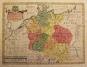
A New Map of Present Germany, Shewing Its Principal Divisions, Cities, Towns, Rivers, Mountains, & c.
Published by Artist: Wells Edward ( - 1727 ) London ca : 1660, 1667
Seller: Antique Sommer& Sapunaru KG, M�nchen, Germany
Seller rating 4 out of 5 stars

Technic: Copper print, colorit: original colored, condition: Perfect condition, size (in cm): 37 x 49 cm, Map shows the whole of Germany, Austria, the Czech Republic and partly Poland. There is also a title cartouche with a coat of arms, a compass rose and a mileage indicator cartouche.
-

A New Map of Present Germany, Shewing Its Principal Divisions, Cities, Towns, Rivers, Mountains, etc.
Publication Date: 1712
Seller: Geographicus Rare Antique Maps, Brooklyn, NY, U.S.A.
Association Member: ABAA ESA ILAB
Seller rating 4 out of 5 stars
Map
Very good. Some wear and toning along original centerfold. Damage to centerfold, repaired. Original platemark visible. Professionally flattened and backed with archival tissue. Minor foxing. Size 15 x 19.5 Inches. This is a beautiful 1712 map of Germany by Edward Wells of Oxford. It covers the entirety of the lands traditionally occupied by the Germanic peoples, from the Gulf of Venice to the Baltic coast as from Holland to Poland. Notes towns, rivers, lakes and other topographic features. A decorative title cartouche appears in the lower right quadrant. This, like many other Wells maps, is dedicated to Prince William, Duke of Gloucester and son of Queen Anne, who, when this map was being prepared, was a student at Oxford. Engraved by R. Spofforth and published by T. Bonwicke for the 1712 edition of Edward Wells' Atlas, A New Sett of Maps both of Ancient and Present Geography . References: Rumsey 11181.016.
-
"A new map of Present Germany, Shewing Its Principal Divisions, Cities, Towns, Rivers, Mountains, & c.",
Language: German
Published by um 1700., 1700
Seller: Kunstantiquariat Tobias M�ller, W�rzburg, Germany
Seller rating 5 out of 5 stars

Map
Kolor. Kupferstichkarte mit kolor. Kartusche, (engl.) Meilenzeiger und Legende von S. Nicholls nach Wells, um 1700. 36,8 x 48,8 cm. - Schwach gebr�unt und minimal fleckig. - Umfasst Deutschland in seinen Grenzen von Kiel �ber Danzig bis an die franz�sische und schweizerische Grenze. Im Osten sind B�hmen und M�hren und im S�den �sterreich mit dem heutigen Slowenien und Kroatien erfasst. Sprache: Deutsch Gewicht in Gramm: 0.