New Accurate Map Post Roads (3 results)
Published by J. Bowles, P. Overton, T. Bowles, John King, London 1740
- Hardcover
- Map
Seller: Donald A. Heald Rare Books (ABAA), New York, U.S.A.Donald A. Heald Rare Books (ABAA)
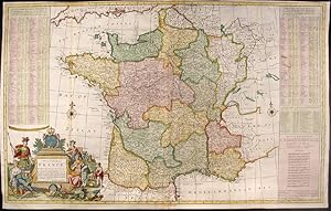
Contact seller5-star sellerHand-coloured engraving. Repaired loss to bottom left corner outside neat line with facsimile border. Trimmed to platemark in places in top margin. Three vertical creases where map was folded into atlas. Multiple creases parallel to center fold. Splits in vertical folds have been rebacked. A superb map of France during the reign… of Louis XV. This large, marvellous Moll map of France bears his distinctive style and the fruits of his diligence. There is a lengthy, alphabetical index of more than 280 towns giving their distances from Paris as well as names and locations of passes through the Pyrenees. The source for this information was Nicolas de Fer. The depiction of France itself includes the roads and the distances from point to point on those roads in leagues, a relatively new feature in maps. Also noted, by a sword and date, are battle sites in which the English were involved or "mentioned in History" as he puts it. The cartouche includes two emblematic figures dressed for battle, one, Bacchus perhaps, the god of wine, and one loosely draped in a cloth adorned with fleur-de-lys who seems to represent French Royalty and, indirectly, French culture.
 More images
Published by John Cumming, 16 Lower Ormond Quay, Dublin 1815
- Hardcover
- First Edition
Seller: Collectible Books Ireland, Portarlington, IrelandCollectible Books Ireland
Contact seller5-star sellerCondition: Used - Good
£ 310.98
£ 25.88 shippingShips from Ireland to U.S.A.Quantity: 1 available
Add to basketHardcover. Condition: Good. No Jacket. 1st Edition. A very scarce first edition with its original map of Ireland, five double-page road maps, an engraved map of the Lakes of Killarney and a plate of the Giant's Causeway plus the frontispiece of the Powerscourt Waterfall. In marbled boards and quarter leather with gilt lettering…to spine. All extremities worn. Pages toned with several spots on early pages. Binding strong. Plain endpapers. Some pencil annotations. Map of Ireland has tape repairs verso. No pen marks. Not ex-lib. Please examine all seller photos.

Published by Not stated
Seller: Hornseys, Ripon, United KingdomHornseys
Contact seller5-star sellerCondition: Used - Very good
£ 115.00
£ 25.00 shippingShips from United Kingdom to U.S.A.Quantity: 1 available
Add to basketNo Binding. Condition: Very Good. DH202106. Printed in c.1780 or earlier. Anonymous but similar to maps of the period by Kitchin and Bowen. Size: 34cm x 34cm. Original copper engraving. Later but not recent hand-colouring. Original fold lines and slight creasing. Occasional very slight foxing. In very good plus, clean condition.… PRICE INCLUDES POSTAGE IN THE UK. FOR WORLDWIDE SHIPPING, PLEASE CONTACT US FOR A QUOTE.


