

Order Total (1 Item Items):
Shipping Destination:

Mitchells Reference Distance Map United by Young (7 results)
Skip to main search results
Search filters
Product Type
- All Product Types
- Books (4)
- Magazines & Periodicals (No further results match this refinement)
- Comics (No further results match this refinement)
- Sheet Music (No further results match this refinement)
- Art, Prints & Posters (No further results match this refinement)
- Photographs (No further results match this refinement)
- Maps (3)
- Manuscripts & Paper Collectibles (No further results match this refinement)
Condition Learn more
- New (3)
- As New, Fine or Near Fine (No further results match this refinement)
- Very Good or Good (No further results match this refinement)
- Fair or Poor (No further results match this refinement)
- As Described (4)
Binding
Collectible Attributes
- First Edition (1)
- Signed (No further results match this refinement)
- Dust Jacket (No further results match this refinement)
- Seller-Supplied Images (7)
- Not Print on Demand (4)
Language (1)
Free Shipping
Seller Location
Seller Rating
-
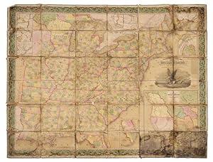
Mitchell's Reference & Distance map of the United States.
Published by Philadelphia: Samuel Augustus Mitchell, 1848 (copyright 1833), 1848
Seller: Arader Galleries - AraderNYC, New York, NY, U.S.A.
Seller rating 5 out of 5 stars

First Edition
Unbound. "Engraved folding wall map with large inset map of Texas, Oregon and California in lower right, several smaller inset maps of the Falls of Niagara, Northern Maine, Rochester, Albany, Washington, Charleston, and Florida on the perimeter (overall 56 x 71 in.; 142.5 x 179.6 cm), hand-colored in wash and outline, dissected in 36 sections and mounted on linen, engraving of an eagle on a seashell grasping an olive branch in his left talon and arrows in the right, flanked by the capitol at Washington and Philadelphia (attributed to William Mason), wide ornate vine border, green cloth selvage. BINDING/CONDITION: Marbled paper outer panels. Dampstained with traces of mold chiefly on the linen backing but occasionally affecting portions of the map, some sections separating from backing at corners, margins of several sections creased. (65B2C) FIRST PRINTING OF A LANDMARK MAP OF THE WEST AND THE FIRST TO INCLUDE AN INSET MAP OF TEXAS. This monumental wall map was produced by Mitchell the same year as his pocket size map of Texas, Oregon and California "[It is] an important map [depicting] the western political situation on the eve of the Mexican War. A composite map, it judiciously incorporated the recent work of Nicollet, Wilkes, Frémont, and Emory. Both the Oregon Trail and the 'Caravan route to Santa Fe' are included" (Schwartz & Ehrenberg). Wheat adds: "This map represents a great step forward [utilizing] the recent explorations that had bounded and determined the nature of the Great Basin. The Texas claim to a western boundary up to the Rio Grande is here shown, with the northern panhandle extending all the way to the 42nd parallel, following Emory's map of Texas" (Wheat). PROVENANCE: Evelyn and Eric P. Newman (sale, Leslie Hindman, 12 November 2018, Lot 89) REFERENCES: Rumsey 4308.000; Schwartz & Eherenberg, The Mapping of America, p. 276; Wheat, Mapping of the Transmississippi (1959) II:35, no. 520 (referring to the pocket map's "Accompaniement")".
-
Mitchell's Reference and Distance Map of the United States
Published by S. Augustus Mitchell, Philadelphia, 1845
Seller: Donald A. Heald Rare Books (ABAA), New York, NY, U.S.A.
Seller rating 5 out of 5 stars
Map
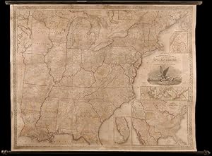
Copper-engraved wall map, with full original colour, expertly repaired, backed with modern linen, trimmed in green cloth, on contemporary rollers, with bright colour, overall in very good condition. An impressive wall map of the United States from a crucial year in American history. In 1834 Mitchell republished his A New Map of the United States under the title of Reference and Distance Map. New, updated editions appeared almost yearly. When compared to the 1833 edition of the former, this 1845 edition of the Reference and Distance Map shows many new developments in the upper Midwest. The outline of Lake Michigan has undergone extensive corrections. An oversized Wisconsin Territory (1836) now appears. Two of the small insets of American towns have been removed from the upper left-hand corner so that the new oversized Territory of Iowa (1838) could be added. The large inset General Map of the United States now shows Texas in its last year as an independent Republic. An important American map, showing the country on the eve of its second great national expansion. Rumsey 4223; Phillips, Maps, p. 898.
-
Softcover. Condition: New. English: Print-on-demand reprint. Original edition: 1834. This modern reproduction of An accompaniment to Mitchell's reference and distance map of the United States: containing an index of the counties, districts, parishes, townships, towns, &c. in the Union, together with an index of the rivers: by which any country, district, township, &c., or river may be found on the map without difficulty: also a general view of the United States and the several states and territories: with an account of the actual and prospective internal improvements throughout the Union: the whole, in connexion with the map, illustrating the geography, topography and statistics of the Union, in a more complete and satisfactory manner than has been hitherto attempted by Mitchell, S. Augustus (Samuel Augustus), 1792-1868; Young, J. H. (James Hamilton); Joseph Meredith Toner Collection (Library of Congress); Wilson, Leslie Jane, 1958- donor makes an old or rare text available for consultation, bibliographic research, and specialized collections. Book images are non-contractual. - Informations complémentaires : Langue : Anglais | Format : Livre broché | État : Neuf | Nombre de pages : 324.
-

Mitchell's Reference and Distance Map of the United States.
Publication Date: 1844
Seller: Geographicus Rare Antique Maps, Brooklyn, NY, U.S.A.
Association Member: ABAA ESA ILAB
Seller rating 4 out of 5 stars

Map
Very good. Full professional restoration including fresh linen backing. Even overall toning. Can be reattached to original rollers upon request. Size 55.75 x 69.75 Inches. This is a rare 1844 edition of S. A. Mitchell and J. H. Young's important large-scale wall map of the United States and the only edition to include both the short-lived Republic of Texas and the even more ephemeral Florida Leigh Read County. A Closer Look Like most maps of the United States predating the Mexican-American War (1846 - 1847), this map covers from the Sabine River to the Atlantic and from the Great Lakes to Florida. There are multiple insets, two of which are of particular note. The largest is a map of the United States with a prominent Republic of Texas exhibiting the pre-1846 borders. To the left, a large inset Florida includes Leigh Read County - an ephemeral county division that never formally materialized (see below). The map also illustrates the 54°40' dispute over U.S. claims in modern-day British Columbia. Republic of Texas The Republic of Texas was a short-lived nation established in March 1836 when it seceded from Mexico. Following the independence of Mexico from Spain, the American Stephen Fuller Austin led a group of 300 Empresarios to settle Texas, near Austin, where they received a grant from the Mexican government. As more Americans moved to Texas, resentment and strife began to build between the American settlers and Mexican authorities. This and other factors ultimately led to the Texan Revolution in 1835 and the declaration of Texan independence in 1836. Texas remained an independent republic until it joined the United States ten years later in 1846. Texas Borders The borders of the Republic of Texas were in dispute from the earliest days of the Texan Revolution. The Republic-claimed borders followed the Treaties of Velasco between the newly created Texas Republic and Mexican leader Antonio López de Santa Anna. The treaties established an eastern boundary following the 1819 Adams-Onís Treaty between the United States and Spain, which established the Sabine River as the eastern boundary of Spanish Texas and the western boundary of the Missouri Territory. The Republic's southern and western boundary with Mexico was more nuanced. Texas claimed the Rio Grande del Norte as its western and southernmost border, while Mexico argued for a boundary much further east at the Nueces River. When Texas was annexed into the United States, the agreement followed the Republic-claimed boundary, thus absorbing Mexican-claimed territory as far west as Santa Fe. This escalated already existing tensions between the United States, the former Republic of Texas, and Mexico, ultimately triggering the Mexican-American War (1846 -1848). Leigh Read County, Florida Leigh Read was born in Tennessee, served as a militia general during the Second Seminole War (1835 - 1842), and was a delegate to the Convention of 1837 lobbying for Florida statehood. Read and fellow Florida Democrats passed a constitutional amendment to prohibit the sale of bonds by the territorial government. The bill garnered Read a host of enemies who would have profited from the bond sales, among them former friend Augustus Alston. In retribution, Alston challenged Read to a duel, a method frequently used by Florida Whigs to dominate territorial politics. Read initially refused the challenge but, after being ridiculed as a coward, agreed. As the challenged, Read selected the weapon, Yager Rifles, and a site in Georgia (to avoid Florida's dueling ban). Alston, a confident and experienced dueler, told his wife to have a sumptuous dinner ready on his return. On a chilly morning in December 1839, Alston and Read faced off. The dueling protocol called for each to take four steps, turn, and fire. As Read and Alston separated, Alston stumbled and misfired. Read, on the other hand, calmly took aim at Alston's chest and fired, killing him instantly. Alston's sister, it is said, dug the bloody slug.
-

Mitchell's Reference and Distance Map of the United States.
Publication Date: 1847
Seller: Geographicus Rare Antique Maps, Brooklyn, NY, U.S.A.
Association Member: ABAA ESA ILAB
Seller rating 4 out of 5 stars
Map
Good. Full professional restoration. Some discoloration, cracking, etc. Fully stabilized. Size 57.75 x 72 Inches. This is the only known example of the 1847 edition of S. A. Mitchell and J. H. Young's important large-scale wall map of the United States. Issued at the end of the Mexican-American War (1846 - 1847), the map reflects new territorial acquisitions from the Treaty of Guadeloupe-Hidalgo, including Texas, New Mexico, California, and what would become Utah, Nevada, and Arizona. Points of interest include ambiguity over the Texas-New Mexico border and the 54°40' dispute over U.S. claims in modern-day British Columbia. A Closer Look The primary map's coverage extends from the Sabine River to the Atlantic, and from the Great Lakes to Florida. There are multiple insets, including the northern part of Maine, and the vicinity of Niagara Falls, Washington D.C. and Baltimore, and Charleston. However, two of the insets are particularly worthy of note. The largest is a reduced version of Mitchell's seminal work A New Map of Texas Oregon and California , notable for many reasons, including a prominent depiction of Texas representing the post-1846 borders. To the left of this extraordinary work is a large inset map of southern Florida from Lake George to Key West. A New Map of Texas Oregon and California The large inset of the American West is in fact Mitchell's seminal A New Map of Texas Oregon and California with the Regions adjoining , first published separately in 1846. Considered to be 'the quintessential trail map of the American West', its inclusion of this stunning wall map makes the piece even more extraordinary. The importance of this map in the history of the American westward expansion cannot be understated. When Brigham Young and the Mormons set out to settle Utah, he famously ordered 6 copies. In fact, one example in the collections of Brigham Young University bears a manuscript annotation identifying Mormon settlements in Utah, making it the first known map to do so. However, it was not only Mormon emigres who took advantage of Mitchell's work, it was simply the best map of the time for anyone planning the long trek westward and was consequently extremely popular. Mitchell's map offered the best published mapping of many of most important transcontinental routes, including the 'Oregon Trail' (up the Platte, across South Pass, and down the Snake to the Columbia), the Caravan Route to Santa Fe (from Jefferson City, roughly following the Arkansas and Salt Fork Rivers, the across modern day Kansas and Colorado to Santa Fe), and the Spanish Trail (from Santa Fe crossing the Rocky Mountains via Salina Canyon before following the Virgin and Mohave Rivers to Los Angeles). Also noted, though given less attention are several old trade routes extending from Louisiana through Texas and into Mexico. Texas Borders The borders of Texas were in dispute from the earliest days of the Texan Revolution. The Republic-claimed borders followed the Treaties of Velasco between the newly created Texas Republic and Mexican leader, Antonio López de Santa Anna. The treaties established an eastern boundary following the 1819 Adams-Onís Treaty between the United States and Spain, which established the Sabine River as the eastern boundary of Spanish Texas and the western boundary of the Missouri Territory. The Republic's southern and western boundary with Mexico was more nuanced. Texas claimed the Rio Grande del Norte as its western and southernmost border, while Mexico argued for a boundary further east at the Nueces River. Still others pushed the border even more aggressively westward to include both the Rio Grande River and the entire Rio Grande Valley, including Santa Fe. When Texas was annexed into the United States, the agreement followed the most aggressive boundary, thus absorbing Mexican-claimed territory, including Santa Fe. This escalated already existing tensions between the United States, the former Republic of Texas, and Mexico, ul.
-
Leather Bound. Condition: New. Language: English. {Size: 19.68 x 24.13 cms} Presenting an Exquisite Leather-Bound Edition, expertly crafted with Original Natural Leather that gracefully adorns the spine and corners. The allure continues with Golden Leaf Printing that adds a touch of elegance, while Hand Embossing on the rounded spine lends an artistic flair. This masterpiece has been meticulously reprinted in 2017, utilizing the invaluable guidance of the original edition published many years ago in 1835. The contents of this book are presented in classic black and white. Its durability is ensured through a meticulous sewing binding technique, enhancing its longevity. Imprinted on top-tier quality paper. A team of professionals has expertly processed each page, delicately preserving its content without alteration. Due to the vintage nature of these books, every page has been manually restored for legibility. However, in certain instances, occasional blurriness, missing segments, or faint black spots might persist. We sincerely hope for your understanding of the challenges we faced with these books. Recognizing their significance for readers seeking insight into our historical treasure, we've diligently restored and reissued them. Our intention is to offer this valuable resource once again. We eagerly await your feedback, hoping that you'll find it appealing and will generously share your thoughts and recommendations. Lang: - English, Pages:- 328, Print on Demand. If it is a multi-volume set, then it is only a single volume. We are specialised in Customisation of books, if you wish to opt different color leather binding, you may contact us. This service is chargeable. Product Disclaimer: Kindly be informed that, owing to the inherent nature of leather as a natural material, minor discolorations or textural variations may be perceptible. Explore the FOLIO EDITION (12x19 Inches): Available Upon Request. 328.
-
Full Leather Bound. Condition: NEW. Language: English. {Size: 19.68 x 24.13 cms} A Unique Premium Leather-Bound book for elite readers/collectors of old rare books. An Original Leather is being used for binding this book with Golden Leaf Printing and designing on Spine, front and Back of the book with edge gilding. WE HAVE MULTIPLE OPTIONS IN COLOR OF LEATHER RED, GREEN, BLUE, MAGENTA, TAN, PURPLE DEEP BROWN, BLACK AND WITH DIFFERENT COLOR LABELS. YOU MAY CHOOSE ANY COLOR OF YOUR CHOICE AND MAIL US. This service is chargeable. Original edition was published in [1835] and this unique edition is Reprinted in 2017 with the help of original edition. Black & white printing on high quality natural shade paper with sewing binding for longer life, professionally processed without changing its contents. As these are old books, we processed each page manually on computer and make them readable. We give our best to give you the best book but in some cases we have to adjust few pages which are blur or missing or black spots. If it is multi volume set, then it is only single volume. We hope that you understand these issues in these old treasure. This is an important book for the readers who want to know more about our old treasure. Our dedicated team is trying to bring these rare books back to the shelves. We are also giving service of printing the hard-to-find books which are not listed in our store. Hope you will like it and give your comments and suggestions. Lang: - English, Pages 328, Print on Demand. Product Disclaimer: Please be aware that because leather is a natural material, slight discoloration or change in texture may be visible. {FOLIO EDITION (Size 12x19 Inches) IS ALSO AVAILABLE ON REQUEST}. 328.



![Seller image for An accompaniment to Mitchell's reference and distance map of the United States 1835 [Leather Bound] for sale by Gyan Books Pvt. Ltd.](https://pictures.abebooks.com/inventory/md/md30274575227.jpg)
![Seller image for An accompaniment to Mitchell's reference and distance map of the United States 1835 [Full Leather Bound] for sale by Gyan Books Pvt. Ltd.](https://pictures.abebooks.com/inventory/md/md32414146704.jpg)