Order Total (1 Item Items):
Shipping Destination:

Map World Known Ancients (17 results)
Skip to main search results
Search filters
Product Type
- All Product Types
- Books (13)
- Magazines & Periodicals (No further results match this refinement)
- Comics (No further results match this refinement)
- Sheet Music (No further results match this refinement)
- Art, Prints & Posters (No further results match this refinement)
- Photographs (No further results match this refinement)
- Maps (4)
- Manuscripts & Paper Collectibles (No further results match this refinement)
Condition Learn more
- New (No further results match this refinement)
- As New, Fine or Near Fine (No further results match this refinement)
- Very Good or Good (7)
- Fair or Poor (1)
- As Described (9)
Binding
- All Bindings
- Hardcover (No further results match this refinement)
- Softcover (4)
Collectible Attributes
- First Edition (1)
- Signed (No further results match this refinement)
- Dust Jacket (No further results match this refinement)
- Seller-Supplied Images (16)
- Not Print on Demand (17)
Language (3)
Free Shipping
- Free Shipping to U.S.A. (No further results match this refinement)
Seller Location
Seller Rating
-

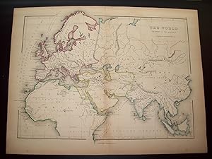
Softcover. Condition: Very Good. 1872. A very presentable colour-printed map from 1872. Clean and well-presented across the entire image surface, with central fold line as originally presented and a few small nicks at the edges repaired and reinforced with conservation tape, but no encroachment onto the printed image, and no other significant creases or wear. Why on Amazon do most sellers not describe their actual book? Buy with confidence and support a genuine Independent Bricks & Mortar Real Bookshop. We are Maynard & Bradley CAMBO & PBFA(now lapsed) members here in Leicester City Centre. Size: 345 x 280 mm. 1. Item Type: Book. Quantity Available: 1. Shipped Weight: Under 500 grams. Category: Geography & Maps; Britain/UK; 19th century; Inventory No: 35241.
-
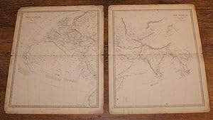
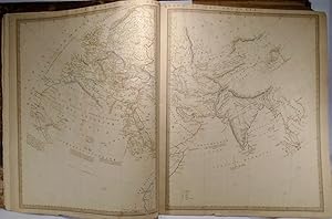
Map of The World as known to the Ancients - in Two Sheets
Published by Edward Stanford, London, 1857
First Edition
Softcover. Condition: Good. Dust Jacket Condition: No Dust Jacket. First Edition. Two disbound map sheets, both with horizontal centre folds, from "The University Atlas of Classical and Modern Geography, including all the Recent Geographical Discoveries". Sheets are titled "The World, as known to the Ancients. Sheet I." and "The World, as known to the Ancients. Sheet II.". Area covered includes Europa (Europe), Libya, Northern Africa, Arabia, Asia, India, Scythia, Terra Incognita, India Extra Gangem, etc. Both sheets are lightly foxed and have slightly darkened edges. Some wear and minor damage to edges and corners. Folds are slightly split at both ends. Folds are a little fragile. Quantity Available: 1. Shipped Weight: under 1 kg. Pictures of this item not already displayed here available upon request. Inventory No: 45019044001. All our books are sent by tracked mail.
-

Softcover. Condition: Very Good. 1854. A well-presented and lightly-handcoloured map, with some minor nicks around the outer page edges but largely clean across the entire image surface and free from any signs of wear beyond a few minor scattered spots. Why on Amazon do most sellers not describe their actual book? Buy with confidence and support a genuine Independent Bricks & Mortar Real Bookshop. We are Maynard & Bradley CAMBO & PBFA(now lapsed) members here in Leicester City Centre. Size: 440 x 320 mm. 1 pages. Item Type: Book. Quantity Available: 1. Shipped Weight: Under 1 kilo. Category: Geography & Maps; Britain/UK; 19th century; Inventory No: 31977.
-
Original Map - "The World as Known to the Ancients"
Published by Blanchard and Lea, Philadelphia, PA
Seller: Barry Cassidy Rare Books, Sacramento, CA, U.S.A.
Seller rating 5 out of 5 stars

Map
No Binding. Condition: Collectible-Very Good. Original publisher's hand-colored map of the world "as known to the ancients." Modern-day Europe, the upper half of Africa, the Middle East, and Asia including Russia, India, China, and part of Southeast Asia are shown. Names such as Europa, Libya (for Africa), Scythia, and Arabia are used. A key beneath the title shows a boundary line with the caption, "boundary of the Persian Empire under Cyrus," suggesting this map is derived from geographic knowledge circa between the seventh and sixth centuries BCE (reign of Cyrus the Great was c. 600-530 BCE). Features beautiful watercolored outlines in blue, pink, green, and yellow around country or regional borders. Major cities and natural features such as mountains, rivers, and oceans are shown. No date, circa 1836-1851. Map with margins measures 13 1/4" x 10"; actual map area measures 11 1/2" x 8 3/8." Map is very clean and intact except for slight foxing. The center fold line is original as this map originally came from an atlas. Lines of latitude and longitude also included. The following is printed beneath the map: "Philadelphia, Blanchard & Lea." "2" printed in upper-right corner outside of the neatline. Blanchard & Lea (fl. 1836-1851) was a Philadelphia-based publishing house and successor to Matthew Carey & Company. George E. Sherman was an American map engraver based in New York and co-founder of the publishing firm, Sherman & Smith or Stiles, Sherman & Smith (fl. c. 1829-1855).
-

Map of the World as Known to the Ancients
Publication Date: 1894
Seller: Art Source International Inc., Boulder, CO, U.S.A.
Seller rating 5 out of 5 stars
This detailed colorful map came from Crams 1894 Universal Atlas -Geographical, Astronomical and Historical. In 1869 the George F. Cram Company was born and the Cram name quickly became synonymous with accuracy and innovation. This map depicts the World as known to the Ancients. This map measures 12.25 inches by 9.25 inches.
-

Map of the World as Known to the Ancients
Publication Date: 1895
Seller: Art Source International Inc., Boulder, CO, U.S.A.
Seller rating 5 out of 5 stars
This detailed map was produced for Crams 1895 "Universal Atlas - Geographical, Astronomical and Historical." In 1869, the George F. Cram Company was born, and the Cram name quickly became synonymous with accuracy and innovation. This map depicts the world as known to ancient society. This map depicts cities, towns, and topographical features. ' This map measures 12.25 inches by 9.25 inches.
-

The Ancient World - Classical Map Showing World Known to Ancients - 'exhibiting the Probable Settlement of the Descendants of Noah' - An Original Antique Map.
Language: English
Publication Date: 1830
Seller: K Books Ltd ABA ILAB, York, YORKS, United Kingdom
Association Member: ABA ILAB PBFA
Seller rating 5 out of 5 stars
No Binding. Condition: Very Good. A splendid original antique delicately (but not contemporary) hand-coloured map. Mounted (matted) and ready to fame. Mount size approx. 11 x 9 inches, 28 x 23 cms. Excellent condition. c. 1830.
-

Map of The World as Known to the Ancients
Publication Date: 1898
Seller: Art Source International Inc., Boulder, CO, U.S.A.
Seller rating 5 out of 5 stars
This colorful map came from Crams 1898 Universal Atlas - Geographical, Astronomical and Historical. In 1869 the George F. Cram Company was born and the Cram name quickly became synonymous with accuracy and innovation. This colorful map details the world as know to the ancients in the second century A.D. This map measures 12.5 inches by 9 inches.
-

Map of the World As Known to the Ancients in the Second Century A.D.
Publication Date: 1900
Seller: Art Source International Inc., Boulder, CO, U.S.A.
Seller rating 5 out of 5 stars
This map was created by George F. Cram for Crams Universal Atlas, Geographical, Astronomical and Historical in 1900. In 1869 the George F. Cram Company was born and the Cram name quickly became synonymous with accuracy and innovation. These maps illustrate cities, towns, major transportation routes, railroads, and topographical features are noted. Maps by George Cram continue to fill collector and gift needs as they have for many years. This map measures 12.5 inches by 9 inches.
-

Map of the World As Known to the Ancients in the Second Century A.D.
Publication Date: 1905
Seller: Art Source International Inc., Boulder, CO, U.S.A.
Seller rating 5 out of 5 stars
This map was made by George F. Cram for "Crams Modern Atlas" in 1905. In 1869 the George F. Cram Company was born and the Cram name quickly became synonymous with accuracy and innovation. Significant bodies of water, cities, and topographic features are labeled. A fine map, excellent for framing. This map measures 12 inches by 9 inches.
-

Map of The World as known to the ancients. (Nr. 37) from Philips' Comprehensive Atlas 1852. By W. Hughes
Language: German
Published by London/Liverpool, Philip & Son., 1852
Seller: Allg�uer Online Antiquariat, Memmingen, DE, Germany
Association Member: GIAQ
Seller rating 5 out of 5 stars
Map
30 cm x 23 cm. Condition: Gut. Eine gefaltete Seite Karte in gutem Zustand, Karte aus dem Buch 'Philips' Comprehensive Atlas', min. randrissig Sprache: Deutsch Gewicht in Gramm: 150.
-

ORIGINAL ENGRAVED Map of The World as Known to the Ancients
Published by Published by Blackie's & Son 1830, 1830
Seller: PROCTOR / THE ANTIQUE MAP & BOOKSHOP, DORCHESTER, United Kingdom
Association Member: PBFA
Seller rating 5 out of 5 stars
Map
Steel Engraved Map Overall size: 11.5 x 8 inches In very good condition. A few faint foxing spots on argins. Steel engraved Religious Map.
-
A Map of the World As Known to the Ancients
Published by Chapman & Hall, London, 1842
Seller: Babylon Revisited Rare Books, Northampton, MA, U.S.A.
Seller rating 4 out of 5 stars

15x24 each. On two sheets. Very detailed map in lovely condition.
-
A Map of the World As Known to the Ancients
Published by Chapman & Hall, London, 1842
Seller: Yesterday's Gallery, ABAA, East Woodstock, CT, U.S.A.
Seller rating 5 out of 5 stars
15x24 each. On two sheets. Very detailed map in lovely condition.
-
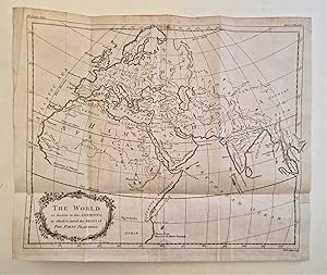
Softcover. Condition: Good. 1764. An original engraving produced in 1764, with some mild browning along the margins and outer edges, but generally clean and well-presented across the image surface with details clear. Small perforation towards the bottom edges, not affecting any sifnificant detail of the print, patched and repaired. One horizontal and three vertical fold lines, as originally presented, with some visible creasing reinforced on the rear side with acid-free conservation tape, some very mild signs of handling but no tears. Small patch at the bottom corner to preserve integrity of margin, not encroaching significantly onto the print itself. Why on Amazon do most sellers not describe their actual book? Buy with confidence and support a genuine Independent Bricks & Mortar Real Bookshop. We are Maynard & Bradley CAMBO & PBFA(now lapsed) members here in Leicester City Centre. Size: 325 x 270 mm. 1. Item Type: Book. Quantity Available: 1. Shipped Weight: Under 500 grams. Category: Geography & Maps; Britain/UK; 18th century; Inventory No: 39952.
-

1808 Map of the World as known to the ancients Europe, North Africa, Saudi Arabia, India by D'Anville
Published by F. C & J. Rivington, London, 1808
Map
No Binding. Condition: Good to Very Good. Condition good, mostly very good, minor dirt, left edge tear, right hand side where attached to book, edge roughly / slightly trimmed, small edge tear, edge folding. As from a book it has been folded from new. Interesting 1808 Map of the World as known to the ancients Europe, North Africa, Saudi Arabia, India by D'Anville and was made for the book Rollin's Ancient History, Printed below map is London, Published by F. C & J. Rivington, July 1 1808 printed in oval Cartouch left side of map is The World as known to the Ancients, Drawn for Rollins Antient History by Mr D'Anville. Printed below map is London, Published by F. C & J. Rivington, July 1 1808 printed in oval Cartouche left side of map is The World as known to the Ancients, Drawn for Rollins Antient History by Mr D'Anville. Total size including boarder open 32 x 37cm ; Size folded 13 x 19.5cm From Net; Jean Baptiste D'Anvil 1697-1782) for Rollins Antient History, published 1808, by F. C. & J. Rivington, engraved by James Bye.
-
Map of the World, as known to the Ancients and Sacred Writers
Published by Hartford, CT, 1855
Seller: Old New York Book Shop, ABAA, Atlanta, GA, U.S.A.
Seller rating 5 out of 5 stars
Map. Condition: Poor. 13.25" x 21" map, a fair to poor copy with edges unevenly cut (see photos) lower right corner and left side have been cut right along edge of map's border. Creased from folding, paper very thin. several tape repairs to verso covering long closed tears.