Order Total (1 Item Items):
Shipping Destination:

Map West Indies by Augustus Mitchell (23 results)
Skip to main search results
Search filters
Product Type
- All Product Types
- Books (20)
- Magazines & Periodicals (No further results match this refinement)
- Comics (No further results match this refinement)
- Sheet Music (No further results match this refinement)
- Art, Prints & Posters (2)
- Photographs (No further results match this refinement)
- Maps (1)
- Manuscripts & Paper Collectibles (No further results match this refinement)
Condition Learn more
- New (No further results match this refinement)
- As New, Fine or Near Fine (2)
- Very Good or Good (3)
- Fair or Poor (No further results match this refinement)
- As Described (18)
Binding
- All Bindings
- Hardcover (No further results match this refinement)
- Softcover (1)
Collectible Attributes
- First Edition (2)
- Signed (No further results match this refinement)
- Dust Jacket (No further results match this refinement)
- Seller-Supplied Images (22)
- Not Print on Demand (23)
Language (1)
Free Shipping
Seller Location
Seller Rating
-
1894 Original Handcolor Map: MEXICO, CENTRAL AMERICA AND WEST INDIES
Published by Chicago : John E. Potter & Company, 1894
Map
Map. Condition: Very Good. Original hand-colored leaf from John E. Potter and Company's, "The New Family Atlas." Please refer to photo for condition. PLEASE NOTE: If two images are shown they represent the obverse and reverse of the same leaf--not two separate leaves. Overall dimensions approx. 26" x 15.25". This item will be shipped flat.
-

MAP: West Indies, including the Island of Cuba (#XXI.from Mitchell's Modern Atlas)
Published by Buer, Philadelphia, PA, 1886
Seller: Dorley House Books, Inc., Hagerstown, MD, U.S.A.
Seller rating 4 out of 5 stars

Art / Print / Poster First Edition
Unbound. Condition: Very Good. Handcolored/copperplate (illustrator). 1st. ' colored map; South America on reverse. suitable for framing Size: 9" x 12".
-
Map of Mexico, Central America, and the West Indies
Published by Philadelphia c.1879, Philadelphia, 1879
Seller: High Ridge Books, Inc. - ABAA, South Deerfield, MA, U.S.A.
Association Member: ABAA ESA ILAB SNEAB
Seller rating 5 out of 5 stars

Double-page map of the southern portion of North America, including Mexico, Central America, and the Caribbean Islands. Inset maps of Bermuda, Jamaica, Hawaii and the Sandwich Islands, and a map of a prospective route for a railroad across the Panamanian Isthmus. Full color by country. On the verso are single page maps of Alaska and Cuba. Copyright date is 1879, but it is not clear which edition of Mitchell's General Atlas this is from.
-
1866 HUGE Color Steel Engraved Map of CENTRAL AMERICA Mexico Cuba West Indies
Published by Philadelphia : S. Augustus Mitchell, 1866., 1866
No Binding. Condition: Very Good. 1866 HUGE Color Steel Engraved Map of CENTRAL AMERICA Mexico Cuba West Indies Samuel Augustus Mitchell (1790 1868) was an American geographer. Map maker: Samuel Augustus Mitchell Title: "Map of Mexico, Central America, and the West Indies." Atlas Title: Mitchell's New General Atlas containing maps of the various countries of the world, plans of cities, etc., embraced in fifty-eight quarto maps, forming a series of ninety-two maps and plans, together with valuable statistical tables. Published: Philadelphia : S. Augustus Mitchell, 1866. Note: double page map FREE SHIPPING WORLDWIDE Wear: wear as seen in photos Publisher: Philadelphia : S. Augustus Mitchell, 1866. Size: ~34in X 14in (85cm x 35.5cm) Photos available upon request.
-

Map of the West Indies
Publication Date: 1881
Seller: Art Source International Inc., Boulder, CO, U.S.A.
Seller rating 5 out of 5 stars
This map was produced by S.A. Mitchell in 1878 for his New Intermediate Geography. The map is nicely hand water-colored. Soon after this time period all maps were mass produced using printed color plates. This map would be a great educational tool for the West Indies. There is a table on the bottom left that asks several questions on the map that may be useful when giving a lecture or teaching the geography of the West Indies. This map measures 10.75 inches by 8.25 inches.
-

Map of West Indies
Published by Philadelphia, 1846
Seller: Trillium Antique Prints & Rare Books, Franklin, TN, U.S.A.
Seller rating 2 out of 5 stars

Art / Print / Poster First Edition
Condition: Fine. 1st Edition. This hand-colored map is from Samuel Augustus Mitchell's "A New Universal Atlas Containing Maps of the various Empires, Kingdoms, States and Republics of the World. With a special map of each of the United States, Plans of Cities &c". The work was published in Philadelphia by the Author in 1846. --- Samuel Augustus Mitchell (1792-1868) and his sons were leading map publishers in the United States in the 19th century. Mitchell moved to Philadelphia c1830 in the hopes to improve geography textbooks and American cartographical information. He acquired the rights to Tanner's "New Universal Atlas" (first published in 1836), and issued his first printing of the work in 1846. --- The work is in very good to excellent condition overall. There may be some light toning or spotting to the plates. There may be a few minor imperfections or faint marks to be expected with age. Please review the image carefully for condition and contact us with any questions. --- Paper Size ~ 14" by 17 1/2".
-

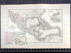
Map of Mexico, Central America, and the West Indies
Published by Augustus Mitchell, Philadelphia, 1860
Seller: PLAZA BOOKS ABAA, Port Townsend, WA, U.S.A.
Seller rating 1 out of 5 stars

Folio, double-page, from Mitchell's New General Atlas, extending from southern US to northern South America. 34x54cm in the image, with about 2.5 cm on all edges. Engraved by Williams of Philadelphia. There are four inset, detailed maps of Cuba, Jamaica, Bermudas, and the Panama Railroad. Brightly colored, very attractive. Center fold split about 6 cm at bottom, closed. Very good condition.
-

Map of Mexico, Central America, and the West Indies
Published by Mitchell, Samuel Augustus Jr., Philadelphia, 1860
Seller: Argosy Book Store, ABAA, ILAB, New York, NY, U.S.A.
Seller rating 5 out of 5 stars
unbound. W. Williams (illustrator). Map. Engraving with original hand coloring. Image measures 13.25" x 21". Beautiful first edition map of Mexico, Central America, and the Caribbean published in 1860. Centered on the Gulf of Mexico. Includes four insets: Map of the island of Jamaica, Mpa of the Island of Cuba, Map of the Bermuda Islands, and Map of the Panama Railroad. This map is in very good condition. Folded as issued. Minor chipping to bottom of centerfold, not affecting the image. Samuel Augustus Mitchell Sr. (1792-1868) was one of the leaders in American cartography of the 19th century and pioneered the conversion of engraved map plates to more affordable lithographic plates. His son, Samuel Augustus Mitchell Jr. continued his father's successful mapmaking and publishing business, and was one of the most prolific and renowned 19th century American publishers.
-
Map of Mexico, Central America, and the West Indies. (with four insets) 49. Map of the Island of Cuba. 50. Map of the Island of Jamaica. 51. Map of the Bermuda Islands. 52. Map of the Panama Railroad.
Published by S.A. Mitchell Jr., Philadelphia, 1865
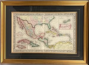
Steel Engraving, hand colored. Condition: Near Fine. Single leaf, with center fold. 34cm x 54cm measurements to outer edge of decorative border. Steel engraving with elaborate hand coloring. Professionally framed, with frame measurements of 54cm x 73cm, gilt frame, glazed with optically correct glass. A very handsome package; Mitchell's "Map of Mexico, Central America, and the West Indies." professionally framed. Map condition is near fine with brilliant color, and only superficial wear. Source: Mitchell's New General Atlas, Philadelphia: Published By S. Augustus Mitchell, Jr. No. 31 South Sixth Street. 1865. Second state. [pg #48 in upper right corner].
-

Map of Mexico, Central America, and the West Indies
Publication Date: 1887
Seller: Art Source International Inc., Boulder, CO, U.S.A.
Seller rating 5 out of 5 stars
This map was made by S. Augustus Mitchell for "Mitchell's New General Atlas" published in 1887. The well maintained maps in this atlas feature Mitchell's characteristic pastel coloring and abundant details of geographical features. Central America, Mexico and the West Indies are illustrated on this map. Insets show the islands of Bermuda, Jamaica, the Nicaragua Canal, the Panama Railroad, and the Isthmus of Tehuantepec. Details include the names of regions, important towns, rivers, lakes, and mountain ranges. Regions are distinguished by color. These 1887 maps offer a fascinating perspective of areas that have since undergone significant growth and change, in addition to their value as great examples of Mitchell's work. This map has water stains in the margin that do not affect the map. This map measures 21.5 inches by 13.5 inches.
-

Map of Mexico, Central America and the West Indies
Publication Date: 1867
Seller: Art Source International Inc., Boulder, CO, U.S.A.
Seller rating 5 out of 5 stars
The Mitchell company was one of the first to try out the new technique of engraving on steel plates, experimenting with steel almost 20 years before the rest of the publishing industry. He was printing with steel in the early 1830s; the general switch to steel was approximately 1850. During the early years of the company, Mitchell published mainly maps and travel guides. In 1860, Mitchell started producing "Mitchell's New General Atlas", and Mitchell Sr. retired and turned the business over to his son of the same name. The New General Atlas was published until 1893. Today Mitchell maps are sought after for their fine engraving, bright coloring, and attention to detail. They are some of the finest maps produced in the 1860's. This map produced in 1867, has Mitchell's unique floral border, and beautiful hand coloring. This map details Mexico, Central America and the West Indies. Four inset maps are included, showing the Bermuda Islands, a map of the Panama railroad, Cuba and Jamaica. This map measures 21 inches by 13 inches.
-

Map of Mexico, Central America, and The West Indies, with Insets of Sandwich Islands, Jamaica, Bermuda, and the Panama Railroad
Publication Date: 1875
Seller: Art Source International Inc., Boulder, CO, U.S.A.
Seller rating 5 out of 5 stars
This map was produced by S. Augustus Mitchell in 1875 for his New General Atlas. This map shows Mitchells traditional grape vine border, characteristic pastel coloring and abundant details of geographical features. Counties are distinguished by different colors. Wagon trails and major routes of transport are also shown. These 1875 maps offer a fascinating perspective of areas that have since undergone significant growth and change, in addition to their value as great examples of Mitchell's work. This map measures 21.5 inches by 13.5 inches.
-

Mitchell's 1865 Map of Mexico, Central America, and the West Indies
Publication Date: 1865
Seller: Art Source International Inc., Boulder, CO, U.S.A.
Seller rating 5 out of 5 stars
In 1860 S. Augustus Mitchell Jr. took over his father's map publishing business and in that year he started publishing Mitchell's New General Atlas. Editions of the new general were issued annually until 1887. Mitchell Jr. continued publishing this atlas until 1879. The editions from 1880 to 1887 were published by Wm. M. Bradley. This map published in 1865 is a wonderful example of Mitchell's map-making prowess with beautiful original hand-coloring. This map measures 21 inches by 13.5 inches.
-

Map of Mexico, Central America, and the West Indies
Publication Date: 1864
Seller: Art Source International Inc., Boulder, CO, U.S.A.
Seller rating 5 out of 5 stars
The Mitchell company was one of the first to try out the new technique of engraving on steel plates, experimenting with steel almost 20 years before the rest of the publishing industry. He was printing with steel in the early 1830's; the general switch to steel was approximately 1850. During the early years of the company, Mitchell published mainly maps and travel guides. In 1860, Mitchell started producing "Mitchell's New General Atlas", and Mitchell Sr. retired and turned the business over to his son of the same name. The New General Atlas was published until 1893. Today Mitchell maps are sought after for their fine engraving, bright coloring, and attention to detail. They are some of the finest maps produced in the 1860's. This map produced in 1864, shows Mitchell's famous artsy flower border, which is only seen in the early editions of his atlases. This map shows Mexico, Central America, and West Indies. Also shown are inset maps of the Bermuda Islands, map of the Panama railroad, Cuba, and Jamaica. This map measures 21 inches by 13 inches.
-

Map of Mexico, Central America and the West Indies with Inset Maps of Bermuda, Panama, Cuba, and Jamaica
Publication Date: 1866
Seller: Art Source International Inc., Boulder, CO, U.S.A.
Seller rating 5 out of 5 stars
The Mitchell company was one of the first to try out the new technique of engraving on steel plates experimenting with steel almost 20 years before the rest of the publishing industry. He was printing with steel in the early 1830s; the general switch to steel was approximately 1850. During the early years of the company, Mitchell published mainly maps and travel guides. In 1860, Mitchell started producing "Mitchell's New General Atlas",and Mitchell Sr. retired and turned the business over to his son of the same name. The New General Atlas was published until 1893. Today Mitchell maps are sought after for their fine engraving, bright coloring, and attention to detail. They are some of the finest maps produced during this time period. This map produced in 1866, has Mitchell's unique floral border, and beautiful hand coloring. This map details Mexico, Central America and the West Indies with Inset Maps of Bermuda, Panama, Cuba, and Jamaica. Counties, cities, towns, lakes, rivers, mountains, and transportation routes are noted. Each map was printed on thick paper with vibrant hand color. This map measures 21 inches by 13 inches.
-

Map of Mexico, Central America and the West Indies
Publication Date: 1872
Seller: Art Source International Inc., Boulder, CO, U.S.A.
Seller rating 5 out of 5 stars
A beautiful map of Mexico, Central America and the West Indies. Four inset maps are included, illustrating the Bermuda Islands, the Panama Railroad, the Sandwich Islands, Hawaii and Jamaica. Regions, cities, topographical features, surrounding smaller islands, and railroads are illustrated. This map measures 22 inches by 13 inches.
-

Map of Mexico, Central America, and the West Indies
Publication Date: 1863
Seller: Art Source International Inc., Boulder, CO, U.S.A.
Seller rating 5 out of 5 stars
The Mitchell company was one of the first to try out the new technique of engraving on steel plates, experimenting with steel almost 20 years before the rest of the publishing industry. He was printing with steel in the early 1830s; the general switch to steel engraving was approximately 1850. During the early years of the company, Mitchell published mainly maps and travel guides. In 1860, Mitchell started producing "Mitchell's New General Atlas". Mitchell Sr. retired and turned the business over to his son of the same name. The New General Atlas was published until 1893. Today Mitchell maps are sought after for their fine engraving, bright coloring, and attention to detail. They are some of the finest maps produced in the 1860's. This map, produced in 1863, shows Mitchell's famous flower border, which is only seen in the early editions of his atlases. This map shows Mexico, Central America, and the West Indies, with Cuba, Jamaica, the Bermuda Islands, and the route of the Panama Railroad also featured. This map measures 21 inches by 13 inches.
-

Map of Mexico, Central America, and the West Indies
Publication Date: 1878
Seller: Art Source International Inc., Boulder, CO, U.S.A.
Seller rating 5 out of 5 stars
This map of Mexico, Central America and the West Indies was produced by Augustus Mitchell in 1878 for his New General Atlas. Highlights of this map are Mitchells traditional grapevine border, characteristic pastel coloring and abundant details of geographical features. This map includes Jamaica, the Bermuda Islands, the Sandwich Islands, and the Panama Railroad. This 1878 map offers a fascinating perspective of areas that have since undergone significant growth and change, in addition to the value as great examples of Mitchell's classic mapmaking style. This map measures 21.5 inches by 13.5 inches.
-

Map of Mexico, Central America, and the West Indies
Publication Date: 1868
Seller: Art Source International Inc., Boulder, CO, U.S.A.
Seller rating 5 out of 5 stars
This hand colored map was made for "Mitchells New General Atlas" published by S. Augustus Mitchell, Jr. in 1868. Mexico, Central America, and the West Indies are illustrated on this map. Four insets show a) the Bermuda Islands, b) the Panama railroad, c) the island of Cuba,and d) the Island of Jamaica. Countries are distinguished by color, other detail include the names of countries, and illustrations of mountains, rivers, lakes, and common sea routes. The maps in this atlas have very beautiful coloring- more muted than is typical. This map measures 21 inches by 13 inches.
-

Map of Mexico, Central America, and the West Indies
Publication Date: 1884
Seller: Art Source International Inc., Boulder, CO, U.S.A.
Seller rating 5 out of 5 stars
This map was made by S. Augustus Mitchell for "Mitchell's New General Atlas" published in 1884, by WM. M. Bradley & Co. The well maintained maps in this atlas feature Mitchell's characteristic pastel coloring and abundant geographical features. Details include the names of countries, regions, cities, towns, transportation routes, rivers, lakes, and mountain ranges. Regions are distinguished by color. These 1884 maps offer a fascinating perspective of areas that have since undergone significant growth and change, in addition to their value as great examples of Mitchell's work. This map measures 19.5 inches by 12 inches.
-

Map of Mexico, Central America and the West Indies
Publication Date: 1874
Seller: Art Source International Inc., Boulder, CO, U.S.A.
Seller rating 5 out of 5 stars
This map was produced by S. Augustus Mitchell in 1874 for his New General Atlas. This map shows Mitchells traditional grape vine border, characteristic pastel coloring and abundant details of geographical features. A beautiful map of Mexico, Central America and the West Indies. Four inset maps are included, illustrating the Bermuda Islands, the Panama Railroad, the Sandwich Islands, Hawaii and Jamaica. Regions, cities, topographical features, surrounding smaller islands, and railroads are illustrated. This map measures 21.5 inches by 13.5 inches.
-

Map of Mexico, Central America, and the West Indies.
Publication Date: 1860
Seller: Art Source International Inc., Boulder, CO, U.S.A.
Seller rating 5 out of 5 stars
This beautiful map of Mexico, Central America, and the West Indies was made by S. Augustus Mitchell, in 1860, for his New General Atlas. This map features bright original hand coloring that differentiates regions and country sections, a decorative floral border, and fine detailing. This map also includes four insets of a map of the Island of Jamaica, the Island of Cuba, the Bermuda Islands, and the Panama Railroad. This map measures 21 inches by 13 inches.
-

Mitchell�s 1846 Map of West Indies
Publication Date: 1846
Seller: Art Source International Inc., Boulder, CO, U.S.A.
Seller rating 5 out of 5 stars
This map of the West Indies was issued as part of Samuel Augustus Mitchell's "New Universal Atlas" in 1846. This was the very first year of publication of this atlas. The atlas was comprised of finely engraved and delicately colored maps and plans of all areas of the world. A resurgence of atlas production in North America during the 1840's and 1850's reflected an emerging mass market fueled by prosperity and mobility. Mitchell was in the right place at the right time. A native of Scotland, Mitchell became a prolific publisher of geographical works when he emigrated to the United States. Walter Ristow, famous map historian, notes that Mitchell employed as many as 250 persons in his Philadelphia establishment, which he took over from Henry S. Tanner in the mid-nineteenth century. We hope you enjoy this very rare Mitchell map! This map measures 14.75 inches by 11.75 inches.