
Order Total (1 Item Items):
Shipping Destination:

Map United Provinces Low Countries (9 results)
Skip to main search results
Search filters
Product Type
- All Product Types
- Books (1)
- Magazines & Periodicals (No further results match this refinement)
- Comics (No further results match this refinement)
- Sheet Music (No further results match this refinement)
- Art, Prints & Posters (No further results match this refinement)
- Photographs (No further results match this refinement)
- Maps (8)
- Manuscripts & Paper Collectibles (No further results match this refinement)
Condition Learn more
- New (No further results match this refinement)
- As New, Fine or Near Fine (No further results match this refinement)
- Very Good or Good (7)
- Fair or Poor (No further results match this refinement)
- As Described (2)
Binding
- All Bindings
- Hardcover (No further results match this refinement)
- Softcover (No further results match this refinement)
Collectible Attributes
- First Edition (No further results match this refinement)
- Signed (No further results match this refinement)
- Dust Jacket (No further results match this refinement)
- Seller-Supplied Images (9)
- Not Print on Demand (9)
Language (1)
Free Shipping
- Free Shipping to U.S.A. (No further results match this refinement)
Seller Location
Seller Rating
-
Seven United Provinces Netherlands Low Countries Holland 1780 Bonne map
Publication Date: 1780
Seller: RareMapsandBooks, Dover, NH, U.S.A.
Seller rating 4 out of 5 stars

Map
Condition: good. Carte de la Hollande, prise en general Contenant les Sept Provinces Unies des Pays Bas.(Old Maps, 18th Century Maps, Europe, Low Countries, Netherlands, Holland, United Provinces, Amsterdam, Utrecht, Rotterdam, Haarlem). Issued c. 1780, Paris by M. Bonne. Attractive late 18th century engraved map with lovely hand color. Nice looking example, pleasing age patina, any minor age flaws easy to overlook or forgive. Original center fold as issued. Sheet Measures c. 10" H x 15" W. Engraved Area Measures c. 8 3/8" H x 12 1/2" W. Cartographic Reference (s):Tooley's Dictionary of Mapmakers, vol. 1.[R35872].
-
United Provinces Low Countries Netherlands Belgium 1786 Laporte miniature map
Publication Date: 1786
Seller: RareMapsandBooks, Dover, NH, U.S.A.
Seller rating 4 out of 5 stars
Map
Condition: good. Carte des Pays-Bas Comprenant Les Provinces Unies: Le Brabant, Gueldre, Limbourg, Luxembourg, Haynaut Namur, Flandre, Cambresis et Artois.(Old Maps, 18th Century Maps, Europe, Low Countries, Netherlands, United Provinces, Holland, Zealand, Belgium, Brabant, Flanders). Issued 1786, Paris by Laporte. Fine and uncommon 18th century map with lovely hand color. Multiple original fold-lines as issued for a rare miniature pocket sized atlas. Sheet measures c. 7 7/8" H x 9 1/2" W. Printed area measures c. 6 7/8" H x 8 5/8" W. ven der Heijden, Old Maps of the Netherlands, 309. Tooley's Dictionary of Mapmakers, v.3, p.89. [B14696].
-
Seven United Provinces Low Countries Netherlands Holland Friesland c. 1790 map
Publication Date: 1790
Seller: RareMapsandBooks, Dover, NH, U.S.A.
Seller rating 4 out of 5 stars
Map
Condition: good. The Seven United Provinces from the Best Authorities.(Old Maps, 18th Century Maps, Europe, Low Countries, Netherland, United Provinces, Holland, Zealand, Brabant, Overijssel, Friesland, Gelders, Utrecht, Groningen). Issued c. 1790, London. Late 18th century engraved map with lovely hand color. Nice looking example, pleasing age patina, any minor age flaws easy to overlook or forgive. Original center fold as issued. Sheet Measures c. 8 1/2" H x 10" W. Engraved Area Measures c. 7 1/2" H x 8 3/4" W.[B12305].
-
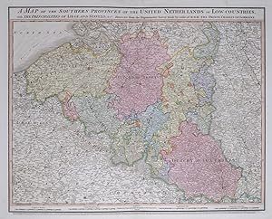
A Map of the Southern Provinces of the United Netherlands or Low Countries, with the Municipalities of Liege and Stavelo, &c.a Reduced from the Trigonometric Survey made by order of H.R.H. the Prince Charles of Lorraine.
Published by LondonWilliam Faden., 1789
Seller: Robert Frew Ltd. ABA ILAB, London, United Kingdom
Association Member: ABA ILAB PBFA
Seller rating 5 out of 5 stars

Map
(Sheet size: 59 x 80 cm). Double page map of Belgium and the Netherlands. Original hand colour. Some light offsetting, else good.
-
Seven United Provinces Netherlands Low Countries Holland 1780 Bonne engraved map
Publication Date: 1780
Seller: RareMapsandBooks, Dover, NH, U.S.A.
Seller rating 4 out of 5 stars
Map
Condition: good. Carte de la Hollande, prise en general Contenant les Sept Provinces Unies des Pays Bas.(Europe, Low Countries, Netherlands, Holland, United Provinces, Amsterdam, Utrecht, Rotterdam, Haarlem). Issued c. 1780, Paris by M. Bonne. Attractive late 18th century engraved map with lovely hand color. Nice looking example, pleasing age patina, any minor age flaws easy to overlook or forgive. Original center fold as issued. Sheet Measures c. 10" H x 15" W. Engraved Area Measures c. 8 3/8" H x 12 1/2" W. Cartographic Reference (s):Tooley's Dictionary of Mapmakers, vol. 1.[R26813].
-
Seven United Provinces Low Countries Holland c. 1801 Oliver & Boyd rare map
Publication Date: 1801
Seller: RareMapsandBooks, Dover, NH, U.S.A.
Seller rating 4 out of 5 stars
Map
Condition: good. The Seven United Provinces from the Best Authorities.(Old Maps, 19th Century Maps, Europe, Low Countries, Netherlands, Seven United Provinces, Holland, Zealand, Brabant, Gelders, Utrecht, Overijssel, Friedland, Groningen). Issued c.1801, Edinburgh by Oliver & Boyd. Possibly engraved by Neele. Very scarce early 19th century engraved map with original hand color. The atlas source of this map is uncited in Tooley's expanded four volume Dictionary of Mapmakers. Appears to not be in the Library of Congress collection. Nice looking example, pleasing age patina, light dustiness and small minor old scattered spots or smudge stains in blank margins, any age flaws minor, easy to overlook or forgive. Original center fold. Sheet Measures c. 11 5/8" H x 14" W. Engraved Area Measures c. 7 1/2" H x 8 1/2" W. Cartographic Reference (s):Tooley's Dictionary of Mapmakers, vol. 3, p. 352 (not noting this atlas nor any near it in date). Phillips, List of Geographical Atlases in Library of Congress, not found.[R32287].
-
17 United Provinces Low Countries Netherlands 1738 Tirion folio antique map
Publication Date: 1738
Seller: RareMapsandBooks, Dover, NH, U.S.A.
Seller rating 4 out of 5 stars
Map
Condition: good. Niuwe en Naukeurige Kaart. der XVII Provincien van Nederland. (Old Maps, 18th Century Maps, Europe, Low Countries, Netherlands, Belgium, Holland, Amsterdam). Issued 1738, Amsterdam by Isaak Tirion. Wonderful mid 18th century engraved folio map. Incredibly detailed. Mostly clean and very well-preserved condition overall, some light minor offsetting, couple spots in bottom blank margin. A strong impression from the plate. Original fold lines as issued. Sheet measures c. 17 3/8" W x 14 3/4" H. Printed area measures c. 13 1/4" W x 11 1/4" H. Folio. Original fold lines as issued. van der Heijden, Oude Kaarten der Nederlanden , 260 (1). Koeman, Atlantes Neerlandici , Tir 2 (38). [B14722].
-
17 United Provinces Low Countries Netherlands Belgium 1730 Lotter folio map
Publication Date: 1730
Seller: RareMapsandBooks, Dover, NH, U.S.A.
Seller rating 4 out of 5 stars
Map
Condition: good. XVII Provincciae - Belgii Sive Germaniae Inferioris.(Old Maps, 18th Century Maps, Europe, Low Countries, United Provinces, Netherlands, Belgium, Luxembourg, Holland, Amsterdam, Utrecht, Brussels, Bruges, Antwerp). Issued 1730, Germany by Lotter. Early 18th century antique engraved map with original hand color. Decorative cartouche greatly enhances visual appeal. Well preserved, nice looking example with pleasing age patina. Original center fold as issued. Sheet Measures c. 20" H x 22" W. Cartographic Reference (s):Tooley's Dictionary of Mapmakers, vol. 3.[R35912].
-

Map of the United Provinces & Low Countries: Early 19th Century - 1802
Seller: Bartele Gallery - The Netherlands, Langweer, FRL, Netherlands
Seller rating 5 out of 5 stars
Antique Map with Title: 'Carte G�n�rale des Provinces Unies et des Pays-Bas' **Publication Details:** - **Atlas Title:** Nouvel Atlas Universel de G�ographie Ancienne et Moderne - **Purpose:** For the Nouvelle Edition de la G�ographie de Guthrie - **Mapmakers:** P. F. Tardieu, with contributions from various geographical works - **Publisher:** Chez Hyacinthe Langlois, Libraire, quai des Augustins, n� 45 - **Year:** An X - 1802 (French Revolutionary Calendar) **Geographical Scope:** This antique map illustrates the United Provinces (Provinces Unies) and the Low Countries (Pays-Bas), covering modern-day Netherlands, Belgium, and parts of surrounding regions. **Map Features:** - **Regions Displayed:** Netherlands, Belgium, and parts of northern France and western Germany. - **Notable Regions and Territories:** Detailed depictions of the United Provinces (Provinces Unies), Flanders, Brabant, Luxembourg, and neighboring regions. - **Seas and Bodies of Water:** North Sea (Mer du Nord), various rivers, and coastal features. - **Topographical Details:** Includes mountain ranges, rivers, and other significant geographical features as understood in the early 19th century. - **Cartographic Style:** Detailed engraving with hand-colored boundaries, emphasizing both historical accuracy and artistic presentation. **Purpose and Use:** This map serves as a detailed visual representation of the geographical and political landscape of the United Provinces and the Low Countries, reflecting the geographical understanding and cartographic style of the early 19th century. It is part of a larger atlas that includes 60 maps, providing a comprehensive view of both ancient and modern geography as known in 1802. ### Condition Report The map is in good condition with minor age-related wear. Hand-colored boundaries are well-preserved, enhancing the clarity of regions and features. Slight fold lines and edge wear are visible, with some age spots. ### Coloring The hand-colored boundaries on the map highlight regions and territories, adding clarity and visual appeal, typical of early 19th-century cartographic practices.


