

Order Total (1 Item Items):
Shipping Destination:

Map Turkey Greece by Augustus Mitchell (20 results)
Skip to main search results
Search filters
Product Type
- All Product Types
- Books (20)
- Magazines & Periodicals (No further results match this refinement)
- Comics (No further results match this refinement)
- Sheet Music (No further results match this refinement)
- Art, Prints & Posters (No further results match this refinement)
- Photographs (No further results match this refinement)
- Maps (No further results match this refinement)
- Manuscripts & Paper Collectibles (No further results match this refinement)
Condition Learn more
- New (No further results match this refinement)
- As New, Fine or Near Fine (No further results match this refinement)
- Very Good or Good (1)
- Fair or Poor (No further results match this refinement)
- As Described (19)
Binding
- All Bindings
- Hardcover (No further results match this refinement)
- Softcover (No further results match this refinement)
Collectible Attributes
- First Edition (No further results match this refinement)
- Signed (No further results match this refinement)
- Dust Jacket (No further results match this refinement)
- Seller-Supplied Images (20)
- Not Print on Demand (20)
Language (2)
Free Shipping
- Free Shipping to U.S.A. (No further results match this refinement)
Seller Location
Seller Rating
-
[Map] Prussia, and the German States [verso with] Map of the Austrian Empire, Italian States. Turkey in Europe, and Greece [with inset] Maltese Islands
Language: English
Published by [W.M. Bradley], [Philadelphia], 1886
Seller: Kaaterskill Books, ABAA/ILAB, East Jewett, NY, U.S.A.
Association Member: ABAA ILAB IOBA
Seller rating 5 out of 5 stars

Hand colored map. Plate 113: [Map] Prussia, and the German States. Copyright by S. Augustus Mitchell 1884. 13.5 x 10.5 inches. [On verso] Plate 114: Map of the Austrian Empire, Italian States, Turkey in Europe, and Greece, with inset Maltese Islands. Copyright by S. Augustus Mitchell 1884. 13.5 x 10.5 inches. From: Mitchell's New General Atlas, Containing Maps Of The Various Countries Of The World, Plans Of Cities, Etc., Embraced In Ninety-Three Quarto Maps, Forming A Series Of One Hundred and Forty-seven Maps and Plans, Together With Valuable Statistical Tables. Also, A List Of Post-Offices Of The United States And Territories, And Also Census Of 1880 For States, Territories And Counties, Also Of Cities Of Over 10,000 Inhabitants. Philadelphia: Published By Wm. M. Bradley & Bro., No. 1026 Arch Street. 1886. Entered . 1883, by S. Augustus Mitchell . Washington. Very good, few minor edge tears, light soiling and staining to margins.
-
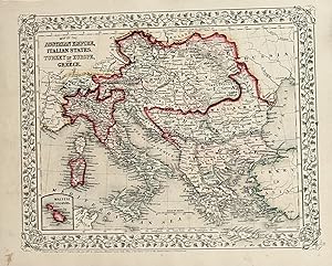
Map of Austrian Empire, Italian States, turkey in Europe and Greece
Published by Mitchell, S. Augustus, Philadelphia, 1867
13 1/4 x 10 3/4. Condition: Very good. Mitchell, S. Augustus (illustrator). 1867 edition. Contemporary hand colored atlas map recapping the complex political divisions of a monarchical Europe. This beautiful map is suitable for matting, framing and hanging on the wall.
-

Map of the Austrian Empire, Italian States, Turkey in Europe, and Greece.
Published by Philadelphia:, 1870
Seller: Nicholas D. Riccio Rare Books, ABAA, Florham Park, NJ, U.S.A.
Seller rating 4 out of 5 stars

Unbound, colored engraved map, decorative border, 14"x 11". Slight toning and aging, top margin a little rough on the edge; overall bright, clear, and crisp and in very good shape. Maps are wrapped with acid free board, or in rigid sleeves.ÃÂ The Mitchell family started to produce atlases in 1846, and continued into the early 1890s. Around 1860, S. Augustus Mitchell Jr. took over, and the atlas would be called Mitchell's New General Atlas. This is a very attractive single page colored map of mostly modern day Germany, Italy, and Turkey from the 1870 installment of that atlas. American maps with a complete picture of Italy are often hard to find.ÃÂ Ristow 311-313.
-

Map of the Austrian Empire, Italian States Turkey in Europe and Greece
Publication Date: 1867
Seller: Art Source International Inc., Boulder, CO, U.S.A.
Seller rating 5 out of 5 stars
The Mitchell company was one of the first to try out the new technique of engraving on steel plates, experimenting with steel almost 20 years before the rest of the publishing industry. He was printing with steel in the early 1830s; the general switch to steel was approximately 1850. During the early years of the company, Mitchell published mainly maps and travel guides. In 1860, Mitchell started producing "Mitchell's New General Atlas",and Mitchell Sr. retired and turned the business over to his son of the same name. The New General Atlas was published until 1893. Today Mitchell maps are sought after for their fine engraving, bright coloring, and attention to detail. They are some of the finest maps produced in the 1860's. This map produced in 1867, has Mitchell's unique floral border, and beautiful hand coloring. This map details the Austrian Empire, Italian States, Turkey in Europe and Greece. A small inset map shows the Maltese Islands. This map measures 13.5 inches by 10 inches.
-

Map of the Austrian Empire, Italian States, Turkey in Europe, and Greece
Published by Philadelphia, 1861
Seller: Nicholas D. Riccio Rare Books, ABAA, Florham Park, NJ, U.S.A.
Seller rating 4 out of 5 stars
Philadelphia, 1861. Unbound, colored engraved map, decorative border, 14"x 11". Slight toning and aging, a little minor staining or soling in rightt margin; overall bright, clear, and crisp and in very good shape. Maps are wrapped with acid free board, or in rigid sleeves. The Mitchell family started to produce atlases in 1846, and continued into the early 1890s. Around 1860, S. Augustus Mitchell Jr. took over, and the atlas would be called Mitchell's New General Atlas. This is a very attractive single page colored map of mostly modern day Germany, Italy, and Turkey from the 1861 installment of that atlas. American maps with a complete picture of Italy are often hard to find. Ristow 311-313.
-

Map of the Austrian Empire, Italian States. Turkey in Europe, and Greece
Publication Date: 1884
Seller: Art Source International Inc., Boulder, CO, U.S.A.
Seller rating 5 out of 5 stars
This map was made by S. Augustus Mitchell for "Mitchells New General Atlas" published in 1884, by WM. M. Bradley & Co. The well maintained maps in this atlas feature Mitchell's characteristic pastel coloring and abundant geographical features. Details include the names of countries, regions, cities, towns, transportation routes, rivers, lakes, and mountain ranges. Regions are distinguished by color. These 1884 maps offer a fascinating perspective of areas that have since undergone significant growth and change, in addition to their value as great examples of Mitchell's work. This map measures 13.5 inches by 10.5 inches.
-

Map of the Austrian Empire, Italian States, Turkey in Europe, and Greece
Publication Date: 1875
Seller: Art Source International Inc., Boulder, CO, U.S.A.
Seller rating 5 out of 5 stars
This map was produced by S. Augustus Mitchell in 1875 for his New General Atlas. This map shows Mitchells traditional grape vine border, characteristic pastel coloring and abundant details of geographical features. Counties are distinguished by different colors. Wagon trails and major routes of transport are also shown. These 1875 maps offer a fascinating perspective of areas that have since undergone significant growth and change, in addition to their value as great examples of Mitchell's work. This map measures 13.5 inches by 11 inches.
-

Map of the Austrian Empire, Italian States, Turkey in Europe and Greece
Publication Date: 1866
Seller: Art Source International Inc., Boulder, CO, U.S.A.
Seller rating 5 out of 5 stars
The Mitchell company was one of the first to try out the new technique of engraving on steel plates experimenting with steel almost 20 years before the rest of the publishing industry. He was printing with steel in the early 1830s; the general switch to steel was approximately 1850. During the early years of the company, Mitchell published mainly maps and travel guides. In 1860, Mitchell started producing "Mitchell's New General Atlas",and Mitchell Sr. retired and turned the business over to his sonof the same name. The New General Atlas was published until1893. Today Mitchell maps are sought after for their fine engraving, bright coloring, and attention to detail. They aresome of the finest maps produced during this time period. This map produced in 1866, has Mitchell's unique floral border, and beautiful hand coloring. This map details the Austrian Empire, Italian States, Turkey in Europe and Greece. Countries, cities, towns, lakes, rivers, mountains, and transportation routes are noted. Each map was printed on thick paper with vibrant hand color. This map measures 13 inches by 10.5 inches.
-

Map of the Austrian Empire, Italian States. Turkey in Europe, and Greece (with an inset map of Maltese Islands)
Publication Date: 1888
Seller: Art Source International Inc., Boulder, CO, U.S.A.
Seller rating 5 out of 5 stars
This map of Austrian Empire, Italian States, Turkey in Europe, and Greece (with an inset map of Maltese Islands) was made by S. Augustus Mitchell for "Mitchells New General Atlas" published in 1888, by WM. M. Bradley & Co. The well maintained maps in this atlas feature Mitchell's characteristic pastel coloring and abundant details of geographical features. Details include the names of countries, cities, towns, transportation routes, islands, mountain ranges, rivers and lakes. These 1888 maps offer a fascinating perspective of areas that have since undergone significant growth and change, in addition to their value as great examples of Mitchell's work. This map measures 13.25 inches by 10.5 inches.
-

Map of Turkey and Greece
Publication Date: 1877
Seller: Art Source International Inc., Boulder, CO, U.S.A.
Seller rating 5 out of 5 stars
This hand colored map was made in 1877 by S. Augustus Mitchell for "Mitchells New General Atlas". Turkey and Greece are illustrated on this map. Insets show the countries surrounding the Black Sea and the Bosphorus. Countries are distinguished by color. Other details include the names of countries, important cities, rivers, mountains, and lakes. This map measures 14.75 inches by 18 inches.
-

Map of Austrian Empire, Italian States. Turkey in Europe, and Greece
Publication Date: 1872
Seller: Art Source International Inc., Boulder, CO, U.S.A.
Seller rating 5 out of 5 stars
S. Augustus Mitchell Jr. made this hand colored map in 1872. The Austrian Empire, Italian States; Turkey in Europe and Greece are illustrated on this map. The Maltese Islands are included in a lower left hand corner inset map. Regions are distinguished by bright pastel colors. Deserts, lakes, mountains, rivers, important cities and countries are identified. This map measures 13 inches by 10.5 inches.
-

Map of the Austrian Empire, Italian States, Turkey in Europe, and Greece, with Inset of Maltese Islands
Publication Date: 1870
Seller: Art Source International Inc., Boulder, CO, U.S.A.
Seller rating 5 out of 5 stars
S. Augustus Mitchell Jr. made this hand colored map for Mitchells New General Atlas in 1870. Regions are distinguished by bright pastel colors. This map includes a small insert of the Maltese Islands. This map measures 13 inches by 10.5 inches.
-

Map of the Austrian Empire, Italian States, Turkey in Europe, and Greece
Publication Date: 1877
Seller: Art Source International Inc., Boulder, CO, U.S.A.
Seller rating 5 out of 5 stars
This hand colored map was made by S. Augustus Mitchell for "Mitchells New General Atlas" in 1877. Austria, Italy, Turkey in Europe, and Greece are illustrated on this map. An inset shows the Maltese Islands at the same scale as the main map. Details include the names of countries and important cities, and illustrations of mountains, lakes, rivers, and major roads. This map measures 13.25 inches by 10.5 inches.
-

Map of the Austrian Empire, Italian States. Turkey in Europe, and Greece.
Publication Date: 1881
Seller: Art Source International Inc., Boulder, CO, U.S.A.
Seller rating 5 out of 5 stars
This map came from Mitchells New General Atlas, 1881. This map shows major railroads, water bodies, and towns. Decorative ivy border, and nice colorful detail. Would look nice framed!' This map measures 13.5 inches by 10.5 inches.
-

Map of the Austrian Empire, Italian States, Turkey in Europe and Greece
Publication Date: 1887
Seller: Art Source International Inc., Boulder, CO, U.S.A.
Seller rating 5 out of 5 stars
This map was made by S. Augustus Mitchell for "Mitchell's New General Atlas" published in 1887. The well maintained maps in this atlas feature Mitchell's characteristic pastel coloring and abundant details of geographical features. The Austrian Empire, Italian States, Turkey in Europe and Greece are illustrated on this map with an inset showing the Maltese Islands. Details include the names of regions, important towns, rivers, lakes, mountain ranges and railroads. Regions and countries are distinguished by color. These 1887 maps offer a fascinating perspective of areas that have since undergone significant growth and change, in addition to their value as great examples of Mitchell's work. This map measures 13.25 inches by 10.5 inches.
-

Map of the Austrian Empire, Italian States, Turkey in Europe, and Greece
Publication Date: 1868
Seller: Art Source International Inc., Boulder, CO, U.S.A.
Seller rating 5 out of 5 stars
This hand colored map was made for "Mitchells New General Atlas" published by S. Augustus Mitchell, Jr. in 1868. Austrian Empire, Italian States, Turkey in Europe, and Greece are illustrated on this map. An inset shows the Maltese Islands at the same scale as the main map. Countries and states are distinguished by color, other details include the names of countries, and illustrations of mountains, rivers, railroads, and lakes. The maps in this atlas have very beautiful coloring- more muted than is typical. This map measures 13.25 inches by 10.5 inches.
-

Mitchell's 1865 Map of the Austrian Empire, Italian States, Turkey in Europe, and Greece
Publication Date: 1865
Seller: Art Source International Inc., Boulder, CO, U.S.A.
Seller rating 5 out of 5 stars
In 1860 S. Augustus Mitchell Jr. took over his father's map publishing business and in that year he started publishing Mitchell's New General Atlas. Editions of the new general were issued annually until 1887. Mitchell Jr. continued publishing this atlas until 1879. The editions from 1880 to 1887 were published by Wm. M. Bradley. This map published in 1865 is a wonderful example of Mitchell's map-making prowess with beautiful original hand-coloring. This map measures 13.5 inches by 10.5 inches.
-

Map of the Austrian Empire, Italian States, Turkey in Europe and Greece
Publication Date: 1874
Seller: Art Source International Inc., Boulder, CO, U.S.A.
Seller rating 5 out of 5 stars
This map was produced by S. Augustus Mitchell in 1874 for his New General Atlas. This map shows Mitchell's traditional grape vine border, characteristic pastel coloring and abundant details of geographical features. Map of the Austrian Empire, Italian States, Turkey in Europe and Greece are illustrated on this map. Countries are distinguished by color. These 1874 maps offer a fascinating perspective of areas that have since undergone significant growth and change, in addition to their value as great examples of Mitchell's work. This map measures 14 inches by 11 inches.
-

Map of Turkey and Greece
Publication Date: 1878
Seller: Art Source International Inc., Boulder, CO, U.S.A.
Seller rating 5 out of 5 stars
This map was produced by Augustus Mitchell in 1878 for his New General Atlas. Highlights of this map are Mitchells traditional grapevine border, characteristic pastel coloring and abundant details of geographical features. This is a beautifully illustrated map of Turkey and Greece. Insets of the Black Sea and Constantinople and the Bosphorus are included. Countries are distinguished by color. This 1878 map offers a fascinating perspective of areas that have since undergone significant growth and change, in addition to the value as great examples of Mitchell's classic mapmaking style. This map measures 15.25 inches by 18.25 inches.
-

Map of the Austrian Empire, Italian States, Turkey in Europe, and Greece.
Publication Date: 1860
Seller: Art Source International Inc., Boulder, CO, U.S.A.
Seller rating 5 out of 5 stars
This beautiful map of the Austrian Empire, Italian States, Turkey in Europe, and Greece was made by S. Augustus Mitchell, in 1860, for his New General Atlas. This map features bright original hand coloring that differentiates regions and country sections, a decorative floral border, and fine detailing. A small inset map of Maltese Islands is included in the lower left hand side of the map. This map measures 13.25 inches by 10.5 inches.
![Seller image for [Map] Prussia, and the German States [verso with] Map of the Austrian Empire, Italian States. Turkey in Europe, and Greece [with inset] Maltese Islands for sale by Kaaterskill Books, ABAA/ILAB](https://pictures.abebooks.com/inventory/md/md31156940495.jpg)

