Order Total (1 Item Items):
Shipping Destination:

Map Scott County by A T Andreas (2 results)
Skip to main search results
Search filters
Product Type
- All Product Types
- Books (2)
- Magazines & Periodicals (No further results match this refinement)
- Comics (No further results match this refinement)
- Sheet Music (No further results match this refinement)
- Art, Prints & Posters (No further results match this refinement)
- Photographs (No further results match this refinement)
- Maps (No further results match this refinement)
- Manuscripts & Paper Collectibles (No further results match this refinement)
Condition Learn more
- New (No further results match this refinement)
- As New, Fine or Near Fine (No further results match this refinement)
- Very Good or Good (1)
- Fair or Poor (No further results match this refinement)
- As Described (1)
Binding
- All Bindings
- Hardcover (No further results match this refinement)
- Softcover (No further results match this refinement)
Collectible Attributes
- First Edition (1)
- Signed (No further results match this refinement)
- Dust Jacket (No further results match this refinement)
- Seller-Supplied Images (2)
- Not Print on Demand (2)
Language (1)
Price
- Any Price
- Under £ 20 (No further results match this refinement)
- £ 20 to £ 35 (No further results match this refinement)
- Over £ 35
Free Shipping
- Free Shipping to U.S.A. (No further results match this refinement)
Seller Location
Seller Rating
-

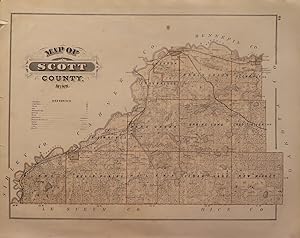
Map of Scott County
Publication Date: 1874
Seller: Art Source International Inc., Boulder, CO, U.S.A.
Seller rating 5 out of 5 stars

This map is from the "Illustrated Historical Atlas of the State of Minnesota," published by A. T. Andreas in 1874. Scott County is illustrated on this map. Details include the names of townships, towns, rivers, lakes, and railroads. This map measures 16 inches by 12 inches.
-
Map of Scott County; Map of Shakopee
Published by A.T. Andreas, Chicago, 1874
Seller: William Chrisant & Sons, ABAA, ILAB. IOBA, ABA, Ephemera Society, Fort Lauderdale, FL, U.S.A.
Association Member: ABAA ESA ILAB
Seller rating 5 out of 5 stars
First Edition
Condition: Very Good. First Edition. Paper. Hand-colored. From the "Illustrated Historical Atlas of the State of Minnesota". 17 1/2 x 14 inches. Map of Shakopee to verso. Light foxing (see image). Two tears to left edge, 1/2 and 1/4 inches.