Map Middle States by Augustus Mitchell (5 results)

Published by S. Augustus Mitchell, Connecticut, 1839
- Map
Seller: mediumraremaps.com, Franklin, TN, U.S.A.mediumraremaps.com
Contact seller4-star sellerCondition: Used - Very good
£ 49.96
£ 4.48 shippingShips within U.S.A.Quantity: 1 available
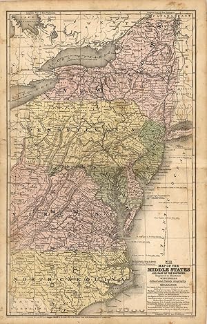
16 3/4 x 10 1/4 inches. Condition: Very good condition. Regional map of New York, Pennsylvania, New Jersey, Maryland, Delaware, Virginia, and North Carolina with smalll portions of neighboring states and Canada. The Appalachian mountains are portrayed in detail. The map has railroads and canals. The map was engraved by J. H. You…ng.It was hand colored at the time of publication.
Seller: Art Source International Inc., Boulder, CO, U.S.A.Art Source International Inc.
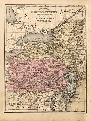
Contact seller5-star sellerThis map was produced by S.A. Mitchell in 1878 for his New Intermediate Geography. The map is nicely hand water-colored. Soon after this time period all maps were mass produced using printed color plates. This map measures 8.25 inches by 10.75 inches.

Published by S. Augustus Mitchell,, Connecticut:, 1839
Seller: Nicholas D. Riccio Rare Books, ABAA, Florham Park, NJ, U.S.A.Nicholas D. Riccio Rare Books, ABAA
Contact seller4-star sellerEngraved colored map, 11" x17", cartouche with map information. Some slight soiling, toning and browning, archival tape repairs on reverse near split, relatively decent margins; map is generally bright and clean. Early Mitchell map of the Middle States the Mitchell's School & Family Geography. New York, Pennsylvania, and Virgini…a are the most visible, but a significant portion of North Carolina is also shown.
Seller: Art Source International Inc., Boulder, CO, U.S.A.Art Source International Inc.
Contact seller5-star sellerThis map was created for Mitchells School Atlas published 1852 by S. Augustus Mitchell. Regions are noted by beautiful hand color. Details include the names of counties, important cities, railroads, lakes, mountains, rivers, and major roads. This map measures 10.5 inches by 16.75 inches.

Seller: Art Source International Inc., Boulder, CO, U.S.A.Art Source International Inc.
Contact seller5-star sellerThis map was created for Mitchells School Atlas published 1839 by S. Augustus Mitchell. Regions are noted by beautiful hand color. This map measures 10.5 inches by 16.5 inches.


