Order Total (1 Item Items):
Shipping Destination:

Map Hundred Wachlingstone by Hasted Edward (3 results)
Feedback
Skip to main search results
Search filters
Product Type
- All Product Types
- Books (1)
- Magazines & Periodicals (No further results match this refinement)
- Comics (No further results match this refinement)
- Sheet Music (No further results match this refinement)
- Art, Prints & Posters (No further results match this refinement)
- Photographs (No further results match this refinement)
- Maps (2)
- Manuscripts & Paper Collectibles (No further results match this refinement)
Condition Learn more
- New (No further results match this refinement)
- As New, Fine or Near Fine (No further results match this refinement)
- Very Good or Good (1)
- Fair or Poor (No further results match this refinement)
- As Described (2)
Binding
- All Bindings
- Hardcover (No further results match this refinement)
- Softcover (No further results match this refinement)
Collectible Attributes
- First Edition (No further results match this refinement)
- Signed (No further results match this refinement)
- Dust Jacket (No further results match this refinement)
- Seller-Supplied Images (3)
- Not Print on Demand (3)
Language (1)
Price
- Any Price
- Under � 20 (No further results match this refinement)
- � 20 to � 35 (No further results match this refinement)
- Over � 35
Free Shipping
- Free Shipping to U.S.A. (No further results match this refinement)
Seller Location
Seller Rating
-
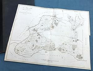
KENT, 1797 - TUNBRIDGE WELLS, HUNDRED OF WACHLINGSTONE, ANTIQUE MAP - HASTED, showing the area between TUNBRIDGE WELLS, PEMBURY & BIDBOROUGH
Published by Bayly Sculp , London / W Bristow, Canterbury., 1797
Seller: End of The World Maps., Penzance, United Kingdom
Seller rating 5 out of 5 stars

Map
� 60
Convert currency� 10 shipping from United Kingdom to U.S.A.Quantity: 1 available
Add to basketNo Binding. Condition: Very Good. KENT, 1797 - TUNBRIDGE WELLS, HUNDRED OF WACHLINGSTONE, ANTIQUE MAP - HASTED, showing the area between TUNBRIDGE WELLS, PEMBURY & BIDBOROUGH A large Original Antique 18th Century copperplate map in it's original, non-coloured state, in VERY GOOD CONDITION - suitable for framing. A `Hundred' stems from Anglo-Saxon when the community was made up of `tithes' (a ten household unit), which was responsible to the `Hundred Court' (normally consisting of ten ` tithes'), and `lathes' (into which the Hundreds were grouped). PROVENANCE: The History and Topographical Survey of The County of Kent by Edward Hasted. Published by W Bristow , The Parade, Canterbury. PRINTED IN : 1797 (2nd Edition). PRINTED by : J Bayly Sculp, London MAP PRINT AREA: 37 x 37 cm, (18.5 x 14.5 inches). SCALE : 1 inch per mile. VERSO: There are no images and/or text printed on the reverse side . CONDITION: Large sheet map , in original non-coloured condition. Centre fold , with usual remains of mounting guide to rear. Light remains of original folds. Normal aging / handling marks to margins consistent with light usage only. Some very minor offsetting and wear to edges, but the printed area is well preserved. Small archival repair to bottom of centrefold, no loss. ( please study photographs to appreciate the good condition this map is in. ) Important Note : Virtually all antiquarian maps and prints are subject to some normal aging due to use and time which is not obtrusive unless otherwise stated. Please note the listing includes the map as described only , any reference / photo of the book the map has been sourced from is for information only. DECLARATION OF AUTHENTICITY: We guarantee the map to be an authentic map published at the date stated above. We do not sell reproductions. THIS MAP IS ACCOMPANIED BY A CERTIFICATE of AUTHENTICITY.
-

A Map of the Hundred of Wachlingstone.
Published by ., 1778
Seller: Robert Frew Ltd. ABA ILAB, London, United Kingdom
Association Member: ABA ILAB PBFA
Seller rating 4 out of 5 stars

Map
� 75
Convert currency� 10 shipping from United Kingdom to U.S.A.Quantity: 1 available
Add to basketOriginal engraved map. (37.5 x 48.5cm, overall sheet 39.5 x 55cm.) 2 vertical fold creases but generally very good. Issued in Hasted's History and Topographical Survey of the County of Kent printed for the author by Simmons and Kirby in 1778.
-

A MAP OF THE HUNDRED OF WACHLINGSTONE.
Published by n.d. but 1778-1801, Canterbury., 1778
Seller: Marrins Bookshop, Folkestone, KENT, United Kingdom
Association Member: ABA ILAB PBFA
Seller rating 4 out of 5 stars
� 70
Convert currency� 25.35 shipping from United Kingdom to U.S.A.Quantity: 1 available
Add to basketUncoloured copper-engraved map (engraved area 19 x 15 inches) with good margins. Scale 2 inches to one mile. A very good copy. The sheet shows Tonbridge in the north, Quarry Hill, Bidborough, Speldhurst and Ashurst to the west, Tudeley, Pembury to the east with Tunbridge Wells to the south, the centre sector is blank as the separate map of the Lowy of Tunbridge fits in here. KENT MAPS KENT MAPS- 18TH CENTURY TOPOGRAPHY KENT.