
Order Total (1 Item Items):
Shipping Destination:

Map Hong Kong Territory Leased by Office Geographical Section General Staff (1 results)
Feedback
Skip to main search results
Search filters
Product Type
- All Product Types
- Books (No further results match this refinement)
- Magazines & Periodicals (No further results match this refinement)
- Comics (No further results match this refinement)
- Sheet Music (No further results match this refinement)
- Art, Prints & Posters (No further results match this refinement)
- Photographs (No further results match this refinement)
- Maps (1)
- Manuscripts & Paper Collectibles (No further results match this refinement)
Condition Learn more
- New (No further results match this refinement)
- As New, Fine or Near Fine (No further results match this refinement)
- Very Good or Good (No further results match this refinement)
- Fair or Poor (No further results match this refinement)
- As Described (1)
Binding
- All Bindings
- Hardcover (No further results match this refinement)
- Softcover (No further results match this refinement)
Collectible Attributes
- First Edition (No further results match this refinement)
- Signed (No further results match this refinement)
- Dust Jacket (No further results match this refinement)
- Seller-Supplied Images (1)
- Not Print on Demand (1)
Language (1)
Price
- Any Price
- Under � 20 (No further results match this refinement)
- � 20 to � 35 (No further results match this refinement)
- Over � 35
Free Shipping
- Free Shipping to United Kingdom (No further results match this refinement)
Seller Location
Seller Rating
-
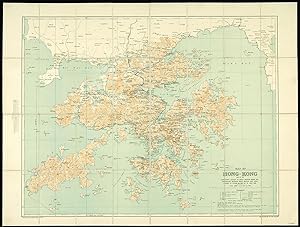
Map of Hong Kong and the Territory leased to Great Britain under the Convention between Great Britain and China, signed at Peking on the 9th of June 1898.
Published by Hong Kong,, 1922
Seller: Daniel Crouch Rare Books Ltd, London, United Kingdom
Association Member: ABA ILAB PBFA
Seller rating 4 out of 5 stars

Map
Hong Kong - the ailing Qing dynasty leased to Great Britain, 1898 Colour lithographed map, dissected and mounted on linen, folding map. An early, attractive, and detailed map of Hong Kong and the New Territories first published in 1905 and re-issued with additions in 1922. From another example of this chart we have handled, it appears that the coastline from Sai Kung to Mirs Point onwards was taken from Admiralty charts; that of Deep Bay, from the mouth of the Sham Chun River to South-West Point, from a survey by the P.W.D.; thence northward and westward from Admiralty charts; that of Lan Tao and adjacent islands from a 1-inch map compiled by Tate; and the New Territories from a map compiled by W. J. Newland in 1903-04, with additions and revisions by P.W.D. in 1913 and 1922. As listed in the Reference table, the map shows Important Villages & Market Places; Villages; Churches & Mission Stations; Pagodas & Temples; Pass; Heights in Feet above Sea Level; Bridges; Limit of Navigation for Large Junks; Cart Roads; Pack Roads & Paths; Telegraphs; Tramways; Boundary of British Territory; and Railways. "The local spelling of place-names has been followed". This map has been compiled from Existing Intelligence Division maps of Hong Kong; Admiralty Charts; Map of New Territory Kowloon, compiled by Mr. Tate for Colonial Government Survey 1899 1900; Survey of Kowloon and part of New Territory (8 In. 1 Mile) carried out in 1902-1903. The boundary along the Shores of Mirs Bay and Deep Bay is the High Water Mark. It has not yet been surveyed and is only shown provisionally. Geographical Section General Staff No. 1393. Additions, Mar. 1922, War Office, Aug. 1905. Scale 1:84,480 or � Inch to 1 Mile.