Map Europe by Augustus Mitchell (96 results)
Published by Chicago : John E. Potter & Company 1894
- Map
Seller: CorgiPack, Fulton, NY, U.S.A.CorgiPack
Contact seller4-star sellerCondition: Used - Very good
£ 13.19
Free ShippingShips within U.S.A.Quantity: 1 available
Map. Condition: Very Good. Original hand-colored leaf from John E. Potter and Company's, "The New Family Atlas." Please refer to photo for condition. PLEASE NOTE: If two images are shown they represent the obverse and reverse of the same leaf--not two separate leaves. Overall dimensions approx. 13" x 15.25". This item will be sh…ipped flat.
 More images
Language: English
Published by W.M. Bradley, Philadelphia 1886
Seller: Kaaterskill Books, ABAA/ILAB, East Jewett, NY, U.S.A.Kaaterskill Books, ABAA/ILAB
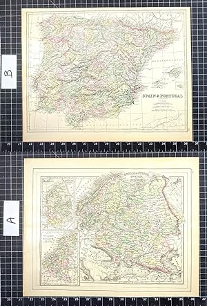
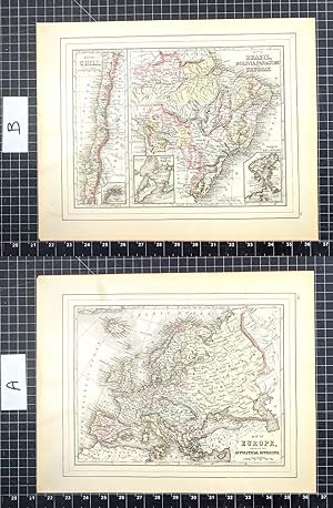
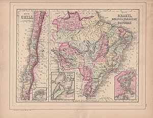
Contact seller5-star sellerHand colored map. Plate 105: Map of Brazil, Bolivia, Paraguay, and Uruguay with two insets of the Harbor of Bahia and the Harbor of Rio de Janeiro [with] Map of Chili, with inset of the Island of Juan Fernandez. Copyright 1886 by Wm. M. Bradley & Bro. 12 x 9.25 inches. [On verso] Plate 106: Map of Europe, Showing Its Gt. Politic…al Divisions. Constructed & Engraved by W. Williams, Philadelphia. Copyright by S. Augustus Mitchell 1884. 13.75 x 11 inches. From: Mitchell's New General Atlas, Containing Maps Of The Various Countries Of The World, Plans Of Cities, Etc., Embraced In Ninety-Three Quarto Maps, Forming A Series Of One Hundred and Forty-seven Maps and Plans, Together With Valuable Statistical Tables. Also, A List Of Post-Offices Of The United States And Territories, And Also Census Of 1880 For States, Territories And Counties, Also Of Cities Of Over 10,000 Inhabitants. Philadelphia: Published By Wm. M. Bradley & Bro., No. 1026 Arch Street. 1886. Very good, faint soiling and browning, few closed edge tears.

Published by S.Augustus Mitchell 1844
- Hardcover
Seller: Harry Alter, Sylva, NC, U.S.A.Harry Alter
Contact seller5-star sellerCondition: Used - Very good
£ 19.46
£ 2.98 shippingShips within U.S.A.Quantity: 1 available
hardcover. Condition: Very Good. S.Augustus Mitchell, Phila. 1844. (c.1843), 8vo. 572pp. + 4pp. of U.S.population by county. 1/2 leather, marbled boards, rubbed & scuffed boards, front cover almost detached, contents foxed, ow VG $.
 More images
Language: English
Published by [W.M. Bradley], [Philadelphia] 1886
Seller: Kaaterskill Books, ABAA/ILAB, East Jewett, NY, U.S.A.Kaaterskill Books, ABAA/ILAB
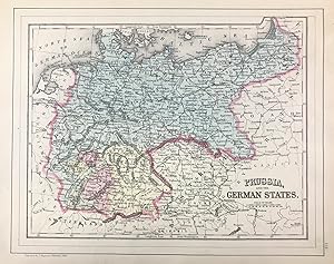
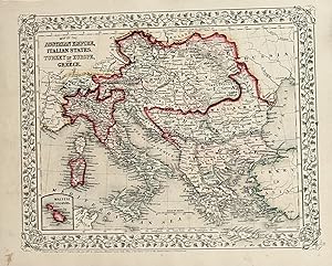
Contact seller5-star sellerHand colored map. Plate 113: [Map] Prussia, and the German States. Copyright by S. Augustus Mitchell 1884. 13.5 x 10.5 inches. [On verso] Plate 114: Map of the Austrian Empire, Italian States, Turkey in Europe, and Greece, with inset Maltese Islands. Copyright by S. Augustus Mitchell 1884. 13.5 x 10.5 inches. From: Mitchell's Ne…w General Atlas, Containing Maps Of The Various Countries Of The World, Plans Of Cities, Etc., Embraced In Ninety-Three Quarto Maps, Forming A Series Of One Hundred and Forty-seven Maps and Plans, Together With Valuable Statistical Tables. Also, A List Of Post-Offices Of The United States And Territories, And Also Census Of 1880 For States, Territories And Counties, Also Of Cities Of Over 10,000 Inhabitants. Philadelphia: Published By Wm. M. Bradley & Bro., No. 1026 Arch Street. 1886. Entered . 1883, by S. Augustus Mitchell . Washington. Very good, few minor edge tears, light soiling and staining to margins.
Language: English
Published by [W.M. Bradley], [Philadelphia] 1886
Seller: Kaaterskill Books, ABAA/ILAB, East Jewett, NY, U.S.A.Kaaterskill Books, ABAA/ILAB
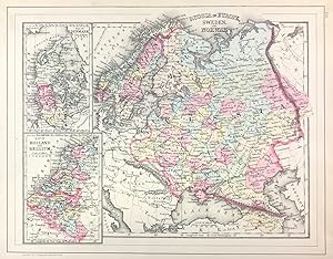
Contact seller5-star sellerHand colored map. 13.75 x 10.5 inches. Plate 112. Russia in Europe, Sweden, and Norway, insets of Map of Denmark, and Map of Holland and Belgium. Copyright by S. Augustus Mitchell 1884. From: Mitchell's New General Atlas, Containing Maps Of The Various Countries Of The World, Plans Of Cities, Etc., Embraced In Ninety-Three Quart…o Maps, Forming A Series Of One Hundred and Forty-seven Maps and Plans, Together With Valuable Statistical Tables. Also, A List Of Post-Offices Of The United States And Territories, And Also Census Of 1880 For States, Territories And Counties, Also Of Cities Of Over 10,000 Inhabitants. Philadelphia: Published By Wm. M. Bradley & Bro., No. 1026 Arch Street. 1886. Very good,minor soiling, one closed edge tear, not affecting contents.

Published by S. Augustus Mitchell,, Connecticut: 1839
Seller: Nicholas D. Riccio Rare Books, ABAA, Florham Park, NJ, U.S.A.Nicholas D. Riccio Rare Books, ABAA
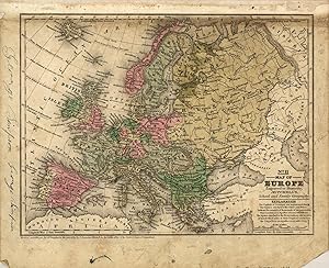
Contact seller4-star sellerEngraved colored map, 9" x12", Box like cartouche with map information. Some soiling, aging and browning, a couple of small holes in top margin where it was bound, not affecting image, otherwise very good. Interesting and detailed small map of Europe. From a school and family geography.
Published by Augustus Mitchell 1860
Seller: Eureka Books, Eureka, CA, U.S.A.Eureka Books
Contact seller5-star sellerMap. Sheet, 12.5 x 15.5. Handcolored in red, blue, yellow, green, and pink First edition thus. Very good copy.
Published by Mitchell, S. Augustus, Philadelphia 1867
Seller: mediumraremaps.com, Franklin, TN, U.S.A.mediumraremaps.com
Contact seller4-star sellerCondition: Used - Very good
£ 46.70
£ 4.53 shippingShips within U.S.A.Quantity: 1 available
13 1/4 x 10 3/4. Condition: Very good. 1867 edition. Contemporary hand colored atlas map recapping the complex political divisions of a monarchical Europe. This beautiful map is suitable for matting, framing and hanging on the wall. Mitchell, S. Augustus (illustrator).

Published by Philadelphia: 1869
Seller: Nicholas D. Riccio Rare Books, ABAA, Florham Park, NJ, U.S.A.Nicholas D. Riccio Rare Books, ABAA
Contact seller4-star sellerUnbound, colored engraved map, decorative border, 14"x 11". Slight toning and aging; overall bright and clear and in very good shape. Maps are wrapped with acid free board, or in rigid sleeves. The Mitchell family started to produce atlases in 1846, and continued into the early 1890s. Around 1860, S. Augustus Mitchell Jr. took o…ver, and the atlas would be called Mitchell's New General Atlas. This is a nice map of Europe from the 1869 installment of that atlas. Despite the large area the map covers, there is still a decent amount of detail. Extra postage may be required. Ristow 311-313. # 103234.

Published by Philadelphia: 1864
Seller: Nicholas D. Riccio Rare Books, ABAA, Florham Park, NJ, U.S.A.Nicholas D. Riccio Rare Books, ABAA
Contact seller4-star sellerUnbound, colored engraved map, decorative border, 14"x 11". Slight toning and aging; overall bright and clear and in very good shape. Maps are wrapped with acid free board, or in rigid sleeves.ÃÂ The Mitchell family started to produce atlases in 1846, and continued into the early 1890s. Around 1860, S. Augustus Mitchell Jr. took… over, and the atlas would be called Mitchell's New General Atlas. This is a colorful single page map of Russia and some Scandinavian countries from the 1864 installment of that atlas. The map includes insets featuring Denmark, and Holland and Belgium.ÃÂ Ristow 311-313.
Published by Philadelphia: 1882
Seller: Nicholas D. Riccio Rare Books, ABAA, Florham Park, NJ, U.S.A.Nicholas D. Riccio Rare Books, ABAA
Contact seller4-star sellerUnbound, colored engraved map, decorative border, 14"x 11". Slight browning and aging, a little foxing in margins; still overall bright and clear and in very good shape. Maps are wrapped with acid free board, or in rigid sleeves. The Mitchell family started to produce atlases in 1846, and continued into the early 1890s. Around 1…860, S. Augustus Mitchell Jr. took over, and the atlas would be called Mitchell's New General Atlas. This is a nice map of Europe from the 1882 installment of that atlas. Despite the large area the map covers, there is still a decent amount of detail. Extra postage may be required. Ristow 311-313. # 103242.
Published by Philadelphia 1861
Seller: Nicholas D. Riccio Rare Books, ABAA, Florham Park, NJ, U.S.A.Nicholas D. Riccio Rare Books, ABAA
Contact seller4-star sellerPhiladelphia, 1861. Unbound, colored engraved map, decorative border, 14"x 11". Slight toning and aging; overall bright and clear and in very good shape. Maps are wrapped with acid free board, or in rigid sleeves. The Mitchell family started to produce atlases in 1846, and continued into the early 1890s. Around 1860, S. Augustus… Mitchell Jr. took over, and the atlas would be called Mitchell's New General Atlas. This is a colorful single page map of Russia and some Scandinavian countries from the 1861 installment of that atlas. The map includes insets featuring Denmark, and Holland and Belgium. Ristow 311-313.

Published by Bradley, Philadelphia 1882
Seller: Nicholas D. Riccio Rare Books, ABAA, Florham Park, NJ, U.S.A.Nicholas D. Riccio Rare Books, ABAA
Contact seller4-star sellerPhiladelphia: Bradley, 1882. Unbound, colored engraved map, decorative boarder, 22 1/2"x 14 1/2". Some toning and aging, a little foxing in margins; otherwise very good. Maps are wrapped with acid free board, or in rigid sleeves. The Mitchell family started to produce atlases in 1846, and continued into the early 1890s. Around 1…860, S. Augustus Mitchell Jr. took over, and the atlas would be called Mitchell's New General Atlas. This is an very interesting double page map of Turkey from the 1882 installment of that atlas. The map shows parts of Austria, Russia, and Armenia, and illustrates the Berlin Congress Treaty of 1878. Map shows some territory annexed by Russia near the Black Sea. Extra postage may be required. Ristow 311-313 Phillips 907.

Published by Philadelphia: 1870
Seller: Nicholas D. Riccio Rare Books, ABAA, Florham Park, NJ, U.S.A.Nicholas D. Riccio Rare Books, ABAA
Contact seller4-star sellerUnbound, colored engraved map, decorative border, 14"x 11". Slight toning and aging, top margin a little rough on the edge; overall bright, clear, and crisp and in very good shape. Maps are wrapped with acid free board, or in rigid sleeves.ÃÂ The Mitchell family started to produce atlases in 1846, and continued into the early 18…90s. Around 1860, S. Augustus Mitchell Jr. took over, and the atlas would be called Mitchell's New General Atlas. This is a very attractive single page colored map of mostly modern day Germany, Italy, and Turkey from the 1870 installment of that atlas. American maps with a complete picture of Italy are often hard to find.ÃÂ Ristow 311-313.
Published by Philadelphia 1861
Seller: Nicholas D. Riccio Rare Books, ABAA, Florham Park, NJ, U.S.A.Nicholas D. Riccio Rare Books, ABAA
Contact seller4-star sellerPhiladelphia, 1861. Unbound, colored engraved map, decorative border, 14"x 11". Slight toning and aging; overall bright and clear and in very good shape. Maps are wrapped with acid free board, or in rigid sleeves. The Mitchell family started to produce atlases in 1846, and continued into the early 1890s. Around 1860, S. Augustus… Mitchell Jr. took over, and the atlas would be called Mitchell's New General Atlas. This is a nice map of Europe from the 1861 installment of that atlas. Despite the large area the map covers, there is still a decent amount of detail. Ristow 311-313.

Seller: Art Source International Inc., Boulder, CO, U.S.A.Art Source International Inc.
Contact seller5-star sellerThis map was produced by S.A. Mitchell in 1878 for his New Intermediate Geography. The map is nicely hand water-colored. Soon after this time period all maps were mass produced using printed color plates. This beautiful map of Europe also includes a table of the Area Square Miles of the main European countries. This map measures… 10.5 inches by 8 inches.
Seller: Art Source International Inc., Boulder, CO, U.S.A.Art Source International Inc.
Contact seller5-star sellerThis map was created for Mitchells School Atlas published 1839 by S. Augustus Mitchell. Regions are noted by beautiful hand color. ' This map measures 10.5 inches by 8 inches.
 More images
Published by Hinman and Dutton, Philadelphia 1837
- Hardcover
Seller: ROBIN RARE BOOKS at the Midtown Scholar, Harrisburg, PA, U.S.A.ROBIN RARE BOOKS at the Midtown Scholar
Contact seller4-star sellerHardcover. Condition: Poor. No Jacket. An Accompaniment to Mitchell's Map of the World, on Mercator's Projection; Containing an Index to the Various Countries, Cities, Towns, Islands, &c., Represented on the Map Also, a General Description of the Five Great Divisions of the Globe, America, Europe, Africa, Asia, and Oceania, with… their Several Empires, States, Territories, &c. By Samuel Augustus Mitchell and printed in Philadelphia by Hinman and Dutton. 1837. 572 pp. 9" x 5.75". 8vo. Hardcover contemporary 3/4 leather. As-is, with scuffing to boards and loss of marbling. Superficial losses to binding on spine. Cracking to hinges at front and rear. Loss of front end page and frontispiece map. Assorted staining remnants. Light markings. General age-related toning to pages, along with periodic foxing and wear. Please see photographs and ask any questions prior to purchasing. A scarce work meant to accompany Samuel Augustus Mitchell's world map. Includes a consulting index at front of map locations of cities, along with a general introduction to nations of the world, of which the Republic of Texas is included.

Seller: Art Source International Inc., Boulder, CO, U.S.A.Art Source International Inc.
Contact seller5-star sellerS. Augustus Mitchell Jr. made this hand colored map in 1872. Russia in Europe, Sweden and Norway are illustrated on this map. Two inset maps of Denmark and Holland and Belgium are located on the left hand side. Regions are distinguished by bright pastel colors. Deserts, lakes, mountains, rivers, important cities and countries ar…e identified. A signature Mitchell ornate floral design frames this antique map. This map measures 13 inches by 10.5 inches.

Seller: Art Source International Inc., Boulder, CO, U.S.A.Art Source International Inc.
Contact seller5-star sellerThe Mitchell company was one of the first to try out the new technique of engraving on steel plates, experimenting with steel almost 20 years before the rest of the publishing industry. He was printing with steel in the early 1830s; the general switch to steel was approximately 1850. During the early years of the company, Mitche…ll published mainly maps and travel guides. In 1860, Mitchell started producing "Mitchell's New General Atlas",and Mitchell Sr. retired and turned the business over to his son of the same name. The New General Atlas was published until 1893. Today Mitchell maps are sought after for their fine engraving, bright coloring, and attention to detail. They are some of the finest maps produced in the 1860's. This map produced in 1867, has Mitchell's unique floral border, and beautiful hand coloring. This map details the Austrian Empire, Italian States, Turkey in Europe and Greece. A small inset map shows the Maltese Islands. This map measures 13.5 inches by 10 inches.

Seller: Art Source International Inc., Boulder, CO, U.S.A.Art Source International Inc.
Contact seller5-star sellerThis map was made by S. Augustus Mitchell for "Mitchells New General Atlas," published by WM. M. Bradley & Co, 1885. This well-maintained example features Mitchell's characteristic pastel coloring and abundant geographical detail. The map shows the nations of Europe in color and identifies cities, rivers, bodies of water, etc. T…his map measures 14 inches by 11 inches.

Seller: Art Source International Inc., Boulder, CO, U.S.A.Art Source International Inc.
Contact seller5-star sellerThis map was made by S. Augustus Mitchell for "Mitchells New General Atlas" published in 1884, by WM. M. Bradley & Co. The well maintained maps in this atlas feature Mitchell's characteristic pastel coloring and abundant geographical features. Details include the names of countries, regions, cities, towns, transportation routes,… rivers, lakes, and mountain ranges. Regions are distinguished by color. These 1884 maps offer a fascinating perspective of areas that have since undergone significant growth and change, in addition to their value as great examples of Mitchell's work. This map measures 13.25 inches by 10.5 inches.

Seller: Art Source International Inc., Boulder, CO, U.S.A.Art Source International Inc.
Contact seller5-star sellerThis map was produced by S. Augustus Mitchell in 1875 for his New General Atlas. This map shows Mitchells traditional grape vine border, characteristic pastel coloring and abundant details of geographical features. Counties are distinguished by different colors. Wagon trails and major routes of transport are also shown. These 18…75 maps offer a fascinating perspective of areas that have since undergone significant growth and change, in addition to their value as great examples of Mitchell's work. This map measures 13 inches by 10.5 inches.

Seller: Art Source International Inc., Boulder, CO, U.S.A.Art Source International Inc.
Contact seller5-star sellerThis map was produced by S. Augustus Mitchell in 1874 for his New General Atlas. This map shows Mitchells traditional grape vine border, characteristic pastel coloring and abundant details of geographical features. A Map of Europe is illustrated on this map. Countries are distinguished by color. These 1874 maps offer a fascinati…ng perspective of areas that have since undergone significant growth and change, in addition to their value as great examples of Mitchell's work' This map measures 14 inches by 11 inches.

Seller: Art Source International Inc., Boulder, CO, U.S.A.Art Source International Inc.
Contact seller5-star sellerOne of the dominant firms in 19th century cartography was unquestionably the Mitchell publishing company. While they had been producing fine quality maps and atlases since the 1830s, they also made instructional material that was up to date and accurate. This map comes from one of the early school atlases published by Mitchell,…and contains a wealth of information, and attractive hand color. The condition is very good, with some mild staining, but mostly outside the image. This map measures 10.5 inches by 8 inches.

Published by Philadelphia 1861
Seller: Nicholas D. Riccio Rare Books, ABAA, Florham Park, NJ, U.S.A.Nicholas D. Riccio Rare Books, ABAA
Contact seller4-star sellerPhiladelphia, 1861. Unbound, colored engraved map, decorative border, 14"x 11". Slight toning and aging, a little minor staining or soling in rightt margin; overall bright, clear, and crisp and in very good shape. Maps are wrapped with acid free board, or in rigid sleeves. The Mitchell family started to produce atlases in 1846,…and continued into the early 1890s. Around 1860, S. Augustus Mitchell Jr. took over, and the atlas would be called Mitchell's New General Atlas. This is a very attractive single page colored map of mostly modern day Germany, Italy, and Turkey from the 1861 installment of that atlas. American maps with a complete picture of Italy are often hard to find. Ristow 311-313.
 More images
Published by Philadelphia : S. Augustus Mitchell, 1866 1866
Seller: Schilb Antiquarian, Columbia, MO, U.S.A.Schilb Antiquarian
Contact seller5-star sellerCondition: Used - Very good
£ 77.06
Free ShippingShips within U.S.A.Quantity: 1 available
No Binding. Condition: Very Good. 1866 Color Steel Engraved Map of EUROPE France UK Spain Austria Italy TURKEY Samuel Augustus Mitchell (1790 1868) was an American geographer. Map maker: Samuel Augustus Mitchell Title: "Map of Europe, showing its Gt. Political divisions." Atlas Title: Mitchell's New General Atlas containing maps… of the various countries of the world, plans of cities, etc., embraced in fifty-eight quarto maps, forming a series of ninety-two maps and plans, together with valuable statistical tables. Published: Philadelphia : S. Augustus Mitchell, 1866. FREE SHIPPING WORLDWIDE Wear: wear as seen in photos Publisher: Philadelphia : S. Augustus Mitchell, 1866. Size: ~17.5in X 14in (44.5cm x 35.5cm) Photos available upon request.

Seller: Art Source International Inc., Boulder, CO, U.S.A.Art Source International Inc.
Contact seller5-star sellerThis map was made by S. Augustus Mitchell for "Mitchells New General Atlas" published in 1884, by WM. M. Bradley & Co. The well maintained maps in this atlas feature Mitchell's characteristic pastel coloring and abundant geographical features. Details include the names of countries, regions, cities, towns, transportation routes,… rivers, lakes, and mountain ranges. Regions are distinguished by color. These 1884 maps offer a fascinating perspective of areas that have since undergone significant growth and change, in addition to their value as great examples of Mitchell's work. This map measures 13.5 inches by 10.5 inches.

Seller: Art Source International Inc., Boulder, CO, U.S.A.Art Source International Inc.
Contact seller5-star sellerWith characteristic floral boarders and beautiful, muted pastel coloring, these 1864 maps are fantastic examples of Mitchells work. Regions, important cities, rivers, lakes, and railroads are identified. The main map on this page illustrates Russia in Europe, Sweden, and Norway, the two insets show Denmark, and Holland and Belgi…um. This map measures 13.5 inches by 10.75 inches.


